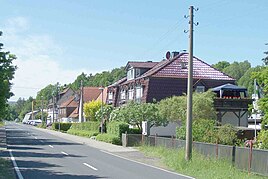
Kambachsmühle
|
Kambachsmühle
Municipality of Krayenberg municipality
Coordinates: 50 ° 51 '4 " N , 10 ° 5' 52" E
|
|
|---|---|
| Height : | 240 m above sea level NN |
| Incorporated into: | Merkers-Kieselbach |
| Postal code : | 36460 |
| Area code : | 036969 |
|
Location of Kambachsmühle in Krayenberggemeinde
|
|
|
In the local area of Kambachsmühle
|
|
Kambachsmühle is a district of the Krayenberg community in the Wartburg district in western Thuringia .
history
The Kambachshof, first mentioned in 1436, was a late clearing settlement on the western slope of the Eichkopf near Kieselbach. The Kambach, which flows past the court, gave this settlement its name. At the lower course of the stream, shortly before the intersection with the federal road 62, there is a dilapidated cellar vault of the ruins of the Kambachsmühle in the undergrowth.
The original settlement of the place is probably related to the nearby Krayenburg and the old trade route from Erfurt to Frankfurt am Main . The vaulted bakers and meadows on the hillside at the edge of the valley show the harsh conditions under which the farmers from Kambachshof had to secure their livelihood.
Around 1907, when the potash industry in the Merkers area was flourishing, a powder factory was built near the homestead. The explosives were needed in large quantities in mining. As an armaments factory, the small factory experienced a further revival with the outbreak of the Second World War ; the factory had previously gone bankrupt in the late 1920s. At the end of the war, the Americans had the factory blown up. Evacuees had already found refuge at Kambachshof during the war, now displaced and homeless people settled in Kambachsmühle and found work in the surrounding pits in Springen.
After potash mining in the Merkers potash district ceased, an investor took over the site of the former powder factory. It became the headquarters of the company "Stahl- und Anlagenbau GmbH Kambachsmühle".
The municipal reform of 1994 led to the merger with Merkers and Kieselbach to form Merkers-Kieselbach. On December 31, 2013, the Krayenberg community was formed from the merger of the communities of Dorndorf and Merkers-Kieselbach .
To the north of the village, along the L 1022 road, there is a pond designated as a nature reserve and, in its vicinity, a fishing pond used as a recreational area.
Web links
Individual evidence
- ^ Festival committee of the anniversary club Kieselbach 1155 eV (Ed.): Festschrift for the local anniversary 850 years Kieselbach . Kieselbach 2005, p. 49-50 .
- ^ Thuringian ordinance on the dissolution and amalgamation of the municipalities of Kieselbach and Merkers of January 20, 1994 (GVBl p. 234), a) § 5 amended by ordinance of April 6, 1994 (GVBl. P. 410)
- ↑ Thuringian Law and Ordinance Gazette No. 12/2013 p. 354 , accessed on October 16, 2016

