
Urnshausen
|
Urnshausen
Dermbach municipality
|
|
|---|---|
 |
|
| Height : | 330 m |
| Area : | 15.99 km² |
| Residents : | 708 (December 31, 2017) |
| Population density : | 44 inhabitants / km² |
| Incorporation : | 1st January 2019 |
| Postal code : | 36466 |
| Area code : | 036964 |
Urnshausen is a district of the municipality of Dermbach in the southern Wartburg district in Thuringia . Urnshausen is also located in the northern part of the Rhön Biosphere Reserve .
geography
The place Urnshausen is located in the Thuringian Rhön , about 10 km south of the district town of Bad Salzungen on a protruding mountain ridge above the central Feldatal .
Urnshausen and the following district to the east of Bernshausen are embedded in a hilly, forested area in the north and east, which is surrounded by the nearby mountains Baier ( 713.9 m above sea level ), Pleß ( 645.4 m above sea level ) and the Stoffelskuppe ( 620.1 m above sea level ) is framed. The hamlet of Hartschimmern on the banks of the Felda also belongs to the village .
The highest elevations in the Urnshäuser and Bernhäuser Flur are the Horn ( 577.7 m above sea level ), the Spitalsberg ( 477 m above sea level ), the Hoher Rain ( 460.2 m above sea level ), the Sandberg ( 445.3 m above sea level ) m above sea level ), the Salzunger Berg ( 435.9 m above sea level ), the Dermbacher Höhe ( 400.6 m above sea level ), the Steinhauk ( 370.9 m above sea level ) and the Kirchberg ( 352.6 m above sea level ) m above sea level ).
Several springs emerge on the slopes of the often wooded mountains, the most famous being Steinborn and Hoher Born . As Erdfallseen are Schönsee and Bernhäuser cowl of particular charm, she drained by beautiful Seebach , Frosch Bach and Wiesenthal Bach in the Felda .
The geological peculiarities of the area include basalt quarries and rock heaps on the Horn as evidence of the Rhön volcanism, as well as the sinkholes in the red sandstone caused by the leaching of near-surface salt domes .
history


The place is first mentioned in a document in 837 in the spelling Orentileshus (later also Oerlshusin and Oernshusen ). The occasion was an exchange of territory that the abbot Hraban of the Fulda monastery entered into with a nobleman named Struodolf who lived in Grabfeldgau . The place name probably means the house of an orentel.
Archaeological finds and still clearly recognizable remains of fortifications on the cone-shaped mountains of Horn, Stoffelskuppe and Bayer are evidence of the prehistoric and early historical importance of the area. Long before the first documentary mention, people who can be assigned to the Celtic culture (Leimbach burial ground) settled in the Werra Valley (with the salt springs of Salzungen , which are important for supraregional trade ) and the neighboring Rhön . Around the birth of Christ, the Rhine-Weser-Germanic tribe of Chatten settled in the area between Werra and Fulda , as well as further west. During the Franconian eastward expansion, between the 5th and 8th centuries, the area in the Thuringian Westergau was also included in a network of newly built Franconian fortifications. With the Frankish colonization of the East, the written traditions began.
The Counts of Neidhartshausen were among the first rulers of the Feldatal area , they were among the guardians of the Fulda monastery. In the 12th century, the counts owned rich property in the Feldatal, including fields in Orenshusen , which was donated to the Zella monastery (founded by Erpho von Neidhardtshausen ); a Würzburg bishop Reginhard is listed as a witness to the document . When the Counts of Neidhartshausen lose their influence and property at the beginning of the 13th century, the Counts of Frankenstein succeed them. The Frankensteiners already resident in neighboring Stadtlengsfeld are also masters of the Dermbacher Cent. In 1258, Ludwig von Frankenstein gave the Urnshaus Church some of the properties near Fischbach (Rhön). The decline of the powerful Counts of Frankenstein began with the siege and destruction of the ancestral castle Frankenstein during a campaign to (West) Thuringia ordered by King Adolf von Nassau in 1295 . As a result of their own weakening and the changed balance of power due to the change of the Landgraviate of Thuringia to the Wettins , the Frankensteiners initially felt compelled in 1326 to sell properties in the Feldatal to their Henneberg relatives.
The noble family of the Lords of Weilar, who were initially in the service of the Hersfeld monastery and builders of a moated castle on the Feldaufer, were also owners of the “Ober-Weilar” farms near Hartschrecken. A branch of the family serving as castle men around 1376 at the Fischberg Castle in Fulda (seat of the Fischberg office of the same name in the Feldatal) was still in possession of the abandoned farms in Obirn Wiler in 1498 .
In the corridor of today's Bernshausen district, another settlement called Berletshausen (also Bertholdes) arose in the High Middle Ages - apparently a foundation of the Lords of Bernshausen , whose preferred name was Berthold. Other noble neighbors had acquired property here. In 1340, the Lords of Wildsprechtroda sold this village, which was already described as a desert in the document , to the Hennebergers. In the same year, the Lords of Bernshausen were Burgmanns at the Salzung Schnepfenburg. This family was also the founder of the Salzung Hospital.
With the extinction of the Henneberger, the balance of power in the Thuringian Rhön was destabilized, both the Catholic Fulda and the Protestant Duchy of Saxony lay claim to inheritance in the border region between the two. Even under the Hennebergers, the Landwehr train of the "Bernshauser Hähl", built as a border fortification, was built on the eastern land border of Bernshausen. The specially secured “Roßdorfer Tor” was also a border crossing and customs post on the medieval trading route leading to Breitungen . The Salzung area was repeatedly devastated and plundered by roaming armies during the Thirty Years' War. Of 124 residential buildings before the war, only 38 were counted in 1659, the number of residents shrank from 123 to 32. The surviving residents of Bernshausen and Urnshausen fled into the woods or died of epidemics that were brought in. Until 1660, the Saxon dukes led a joint government for the Henneberg offices of Kaltennordheim, Zillbach and Fischbach that had been assigned to them. After the Thirty Years' War, Fulda maintained its position, which had been established in Dermbach and the Zella Provost, with the help of the Jesuits.
In 1764, in a settlement with the Duchess Anna-Amalia of Saxony-Weimar, denominational and territorial claims in the Rhön and especially in the Feldatal were newly agreed. The circumstances of the Lords of Boyneburgk, who were seated in the castles of Stadtlengsfeld and who had acquired real estate in almost all places south of Salzungen through purchase or marriage and who were pursuing their own interests, were similarly confused.
When lightning struck Urnshausen during a thunderstorm on May 17, 1865, the church, the parish and more than 70 houses and outbuildings fell victim to the major fire. The burned out church was rebuilt in 1866.
In 1879, based on the 1875 census, statistical information on all places in the Eisenach part of the Grand Duchy of Saxony-Weimar-Eisenach was published.
Urnshausen had 128 houses with 666 inhabitants again in 1875. The size of the field was 1089.0 ha of which farms and gardens 11.4 ha, meadows 153.1 ha, arable land 512.1 ha. Forests 385.2 ha, ponds, streams and rivers 1.9 ha, on paths, drifts , Wasteland and orchards accounted for 25.2 hectares.
The livestock population was also remarkable: 19 horses, 391 cattle, 317 sheep, 96 pigs and 72 goats as well as 86 colonies of bees.
At that time, Bernshausen still belonged to the neighboring duchy of Saxony-Meiningen ( Amt Sand ). Bernshausen also had a church, which was built in 1625 and belonged to the neighboring parish of Rosa to the east. Georg Brückner reports on the location: 164 residents as well as 28 houses and a mill. In addition to the church and a school built in 1743, the place had three public buildings. Because of the mountainous location, sheep farming was important.
On January 1, 2019, the Urnshausen community was incorporated into Dermbach. Before that she belonged to the administrative community Dermbach .
politics
Municipal council
The municipal council from Urnshausen consists of eight council members:
| Party / list | Seats |
|---|---|
| CDU | 2 |
| NPD | 2 |
| LEFT | 1 |
| Volunteer Fire Brigade (Ffw) | 1 |
| Poultry Breeders Association (GV) | 1 |
| Citizens per Urnshausen (BpU) | 1 |
(As of January 25, 2015)
In the municipal council election on May 25, 2014 , the Urnshausen volunteer fire brigade voted 29.8%, ahead of the Left Party (27.2%), the poultry farmers' association (23.5%) and the NPD (19.5%). The municipal supervisory authority of the Wartburg district declared the municipal council election of May 2014 to be invalid as part of an election review because the election regulations had been violated significantly. The election was repeated on January 25, 2015. After a controversial election campaign, the newly founded CDU local group prevailed over the NPD, with a turnout of over 80%.
mayor
The honorary mayor Burkhard Seifert was elected on June 6, 2010.
coat of arms
The coat of arms was designed by the heraldist Uwe Reipert .
District and state politics
In the Thuringian state elections in 2009 , Urnshausen was the municipality with the highest percentage of votes for the NPD (with 25.3% of the first votes and 21.0% of the second votes). The NPD in Urnshausen also received 23.7% of the vote in the 2014 district election .
Attractions
- the striking Protestant parish church in the center of the village was re-consecrated after the major fire in 1868. Parts of the old masonry were reused.
- the Landwehr train Bernshäuser Hähl is on the eastern boundary of the corridor.
- On the Stoffelskuppe and on the Horn there are fortifications from prehistoric times, they were placed under protection as ground monuments.
- the two sinkhole lakes Bernshäuser Kutte and the Schönsee can be accessed via the region's hiking trails. A campsite was set up at the Schönsee.
Personalities
Hildegard Körner (* 1959), track and field athlete and Olympic participant
Urnshausen - behind the Horn

The robe of the Bernshausen

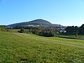
View of Urnshausen - the Pless in the background on the right

The Horn between Urnshausen and Wiesenthal
.jpg)


literature
- Marika Kettner, Sigrid Tanz, Marga Otto: Urnshausen, a village and its people (Ortschronik for the 1175 anniversary in July 2012) . Ed .: Festival Committee. Urnshausen 2012.
- Adalbert Schröter: Country by the road. The history of the Catholic parishes in the Thuringian Rhön . St. Benno Verlag, Leipzig 1989, ISBN 3-7462-0430-5 , p. 77-80 .
- Bruno Kühn: The history of the Dermbach district . In: Journal of the association for Thuringian history and antiquity . tape 1 , 1854, ISSN 0943-9846 , p. 249-296 .
Individual evidence
- ↑ a b c Official topographic maps of Thuringia 1: 10,000. Wartburgkreis, district of Gotha, district-free city of Eisenach . In: Thuringian Land Survey Office (Hrsg.): CD-ROM series Top10 . CD 2. Erfurt 1999.
- ^ Klaus Schmidt: The Wartburg district. Nature and landscape . In: Wartburgkreis (Ed.): Nature conservation in the Wartburgkreis . tape 7 . Printing and publishing house Frisch, Eisenach and Bad Salzungen 1999, p. 87 .
- ^ Geyer, Jahne, Storch: Geological sights of the Wartburg district and the independent city of Eisenach . In: District Office Wartburgkreis, Lower Nature Conservation Authority (Hrsg.): Nature conservation in the Wartburgkreis . Booklet 8. Printing and publishing house Frisch, Eisenach and Bad Salzungen 1999, ISBN 3-9806811-1-4 , p. 160-161 .
- ↑ Otto Dobencker Regesta diplomatica necnon epistolaria historiae Thuringiae (approx. 500 - 1152) vol. 1. Jena 1896
- ^ Paul Lehfeld architectural and art monuments of Thuringia Grand Duchy of Saxony-Weimar-Eisenach. Booklet XXXVII, Jena 1911, pp. 165-166
- ^ A b Georg Brückner: The topography of the country . In: Country studies of the Duchy of Meinigen . tape 2 . Brückner and Renner, Meinigen 1853, p. 92 .
- ↑ Thuringian State Office for Statistics, Urnshausen municipal council election on January 25, 2015 - final result
- ↑ CDU wins municipal council election in Urnshausen. (No longer available online.) MDR, archived from the original on April 2, 2015 ; accessed on January 26, 2015 . Info: The archive link was inserted automatically and has not yet been checked. Please check the original and archive link according to the instructions and then remove this notice.
- ↑ Local elections in Thuringia on May 25, 2014. Elections of the community and city council members. Preliminary results. The regional returning officer, accessed on May 27, 2014 .
- ↑ invalid in Urnshausen , accessed on September 23, 2014
- ↑ New election drew significantly more urn houses to the polls , Südthüringer Zeitung / insuedthueringen.de, January 26, 2015
- ↑ Local elections in Thuringia on June 6, 2010. Elections for community and city council members. Preliminary results. The regional returning officer, accessed on June 6, 2010 .
- ↑ District election 2014, Urnshausen community results , accessed on May 27, 2014.
Web links
- Official journal of the administrative community Dermbach with news of the community Urnshausen - portal of the University of Jena with online archived issues (from 2009).

Bernshausen | Brunnhartshausen | Dermbach | Diedorf | Föhlritz | Glattbach | Housing | Shrinkage | Hohenwart | Lindenau (with Lindigshof ) | Mebritz | Menzengraben | Neidhartshausen | Oberalba | Stadtlengsfeld | Steinberg | Unteralba | Urnshausen | Zella / Rhön