Hard shrinkage
|
Hard shrinkage
Dermbach municipality
Coordinates: 50 ° 44 ′ 9 ″ N , 10 ° 8 ′ 53 ″ E
|
|
|---|---|
| Height : | 310 m above sea level NN |
| Postal code : | 36466 |
| Area code : | 036964 |
|
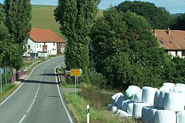
View of hard shrinkage and the field bridge there
|
|
Hard shrinking is a district of Dermbach in the Wartburg district in Thuringia .
location
Hard shrinking is about 1.5 km west of Urnshausen on the federal highway 285 on the eastern bank of the Felda . The geographic height of the place is 310 m above sea level. NN . In the case of hard shrinkage, the state road 1022 from Weilar joins the federal road 285 (section Urnshausen-Dermbach).
history
In the year 1298 Hartschrecken was first mentioned in a document.
From 1880 to 2003 Hartschimmern had a stop on the Feldabahn ; the tracks were dismantled in 2008.
On January 1, 2019, Hartschrecken came to the municipality of Dermbach as part of the incorporation of Urnshausen.
Web links
Commons : Hard Shrinkage - Collection of images, videos and audio files
Individual evidence
- ↑ Official topographic maps of Thuringia 1: 10,000. Wartburgkreis, district of Gotha, district-free city of Eisenach . In: Thuringian Land Survey Office (Hrsg.): CD-ROM series Top10 . CD 2. Erfurt 1999.
- ↑ Thuringia road network map
- ^ Wolfgang Kahl : First mention of Thuringian towns and villages. A manual. Rockstuhl Verlag, Bad Langensalza, 2010, ISBN 978-3-86777-202-0 , p. 110
- ↑ Thuringian Law and Ordinance Gazette No. 14/2018 p. 795 ff. , Accessed on January 18, 2019

