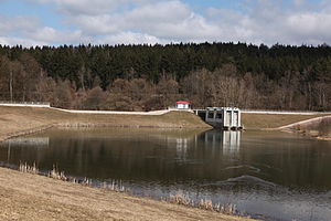
Grimmelshausen flood retention basin
| Grimmelshausen flood retention basin | |||||||
|---|---|---|---|---|---|---|---|
|
|||||||
|
|
|||||||
| Coordinates | 50 ° 28 '36 " N , 10 ° 38' 31" E | ||||||
| Data on the structure | |||||||
| Construction time: | 1984-1990 | ||||||
| Height above valley floor: | 9 m | ||||||
| Height above foundation level : | 12 m | ||||||
| Height of the structure crown: | 349.5 m | ||||||
| Building volume: | 30th 000 m³ | ||||||
| Crown length: | 154 m | ||||||
| Crown width: | 4 m | ||||||
| Slope slope on the air side : | 1: 2.5 | ||||||
| Slope slope on the water side : | 1: 3.5 | ||||||
| Data on the reservoir | |||||||
| Altitude (at congestion destination ) | 347.5 m | ||||||
| Water surface | 85 ha | ||||||
| Storage space | 1.85 million m³ | ||||||
| Total storage space : | 2.33 million m³ | ||||||
| Catchment area | 270 km² | ||||||
| Design flood : | 140 m³ / s | ||||||
The Grimmelshausen flood retention basin is located near Grimmelshausen and Themar in southern Thuringia . It was put into operation in 1991 and dams the Werra during floods.
The barrier structure is a homogeneous earth dam made of alluvial clay . The water side is covered with a pouring stone. The dam is built on alluvial clay and valley gravel. A clay carpet was placed in the storage space for sealing. In the middle of the dam there is a combined overflow structure with the flood relief , the bottom outlet and the dam beams for the permanent damming.
Only a small part of the pool (110,000 m³) is permanently dammed. Most of the space is taken up by the usual flood protection room with 1.74 million m³, which is only dammed during floods .
See also
literature
- Dams in Thuringia, Thuringian dam administration, author college, 1993

