Weserliedanlage
The Weserliedanlage is a memorial erected in 1931 as a roundabout with a viewpoint above the city center of Hann. Münden in the district of Göttingen in southern Lower Saxony ( Germany ). It is reminiscent of the Weser song from 1835 .
Geographical location
The facility is located in the Münden Nature Park, about 600 m north-northwest of the old town of Hann. Münden - between the districts of Questenberg in the east-southeast and Gimte in the north-northwest and the district of Altmünden in the southwest, beyond the origin of the Weser . It is located in the Mündener Bramwald natural area (no. 370.52) at around 187 to 190 m above sea level. NHN on the southwest slope of the Questenberg , a distant southwestern foothill of the Blümer Berg ( 320.4 m ). About 170 m to the south lies the confluence ( 116.5 m ) of the Fulda and Werra to the Weser in the valley .
see also section transport connections and hiking of the article Questenberg (Bramwald)
monument
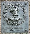
The roundabout of the complex was made of beige sandstones - probably based on a design by the architect Friedrich Grosch - under the direction of August Reich. Bronze panels by the sculptor Gustav Eberlein commemorate the poet of the song text written in 1835, Franz von Dingelstedt , and the composer of the song, Gustav Pressel . The inscription of another plaque on the sloping part of the roundabout contains the text of the Weser song and the inscription on a stone plaque in the outer wall of the complex with "1931", including the year of construction of the monument.
Bronze plaque:
poet of the song,
Franz von DingelstedtBronze plaque:
composer of the song,
Gustav Pressel
Lookout point
From the roundabout of the facility, the view falls into the valley of Hann located between the Bramwald (at the lookout point), the Kaufunger Wald in the southeast and the Reinhardswald in the west. Münden. It extends east past the confluence of the Fulda and Werra to the Weser and the local river island Tanzwerder , on which in particular the Wesersteine are to the old town with the Kattenbühl district beyond . To the west along the island and over the suspension bridge there, one looks up the Fulda in the direction of Neumünden and beyond the origin of the Weser to Altmünden .
Kleine Weser (left next to it), Werra (below left) and Altmünden (right; 2011)
Web links
- Weserliedanlage (description with photos in the culture database), by Andres Imhof, Berlin, on kudaba.de
Individual evidence
- ↑ a b c Stone tablet in the outer wall of the Weserliedanlage , on commons.wikimedia.org
- ↑ Environment map service of the Lower Saxony Ministry for the Environment, Energy and Climate Protection ( information )
- ^ Weserliedanlage (description with photos in the culture database), by Andres Imhof, Berlin, accessed on February 18, 2016, on kudaba.de
Coordinates: 51 ° 25 ′ 21.6 ″ N , 9 ° 38 ′ 56.3 ″ E


