
Tanzwerder
| Tanzwerder | ||
|---|---|---|
 |
||
| Waters | Weser ( Werra , Fulda ) | |
| Geographical location | 51 ° 25 ′ N , 9 ° 39 ′ E | |
|
||

The Tanzwerder is a river island or Werder on the edge of the city center of Hann. Münden in southern Lower Saxony , which has been divided in two by a lock canal since 1897 .
Geographical location
Tanzwerder is located in the Münden Nature Park west of the old town of Hann. Münden. At the top of the Werder is the Weserstein , where at 116.5 m above sea level. NHN the confluence of the Fulda and Werra to the Weser is located. The Tanzwerder lies in the floodplain of these rivers. Originally, this was a swampy landscape in which elevated areas such as the Tanzwerder, the Doktorwerder , the Blümer Werder and the Eselwerder have formed due to the flooding of the river . It was divided into two by the construction of the Fulda lock in the side arm of the river . Looking down from the Fulda river, it consists of the Upper Tanzwerder and the Lower Tanzwerder . The south end of the upper is about 770 m away from the north end of the lower part of the island; both parts are together around 7.8 hectares .
The Tanzwerder can be reached via two bridges over the mill arm of the Fulda. In the south is the (new) Löwenbrücke , a 30 m long road and pedestrian bridge that was built in spring 2015 and opened to traffic on October 1st, 2015. It is a replacement for the 40-year-old, narrower predecessor building (old) Lion Bridge located about 20 m southwest of it , which was demolished in 2016. The west-north-western end of the Tanzwerderstrasse , coming out of the old town, leads across, which , after crossing the Kasseler Schlagd street , reaches the Tanzwerder street across the bridge on the island part . The Gustav-Blume-Weg is laid out as a promenade on the island site parallel to this cul-de-sac with an end loop . Around 150 m northeast of the Löwenbrücke , the Mühlenbrücke leads from the transition area between Kasseler Schlagd and Bremer Schlagd Street to Untere Tanzwerder. It is located west of Mühlenstrasse and is a 76 m long pedestrian bridge that crosses Eselwerder as an approximately 0.2 hectare river island of the Mühlenarm .
In addition, the suspension bridge leads to the Untere Tanzwerder from the Altmünden district to the west as a narrow and around 75 m long pedestrian bridge over the main arm of the Fulda. The Märchenlandweg runs over this bridge near the end of its main path stage 4, which is on the island part, and the beginning of its main path stage 5 there. It ends at the Weserstein with the section Schloss Berlepsch - Hann. Open the stage 17 of the Werra Burgen walkway .
history


The Tanzwerder has served Mündener citizens as an event location since time immemorial. It has been handed down from the year 1411 that bird shooting took place on Whitsun on the Werder . The earliest pictorial representation of the Tanzwerder from 1585 shows the Werdermühle, which stood as a water mill on an arm of the Fulda river. It was located directly opposite the Graumühle on the city side . Around 1730 there was still the field name circle on the river island, which indicates an earlier labyrinth in the style of a Troy castle, in which the expulsion of winter was celebrated. Other uses in the course of time were fairgrounds at folk festivals, circus events and local festivals (1897 and 1909), parade grounds at political rallies, dog racing grounds for the forest academy and soccer field. Tanzwerder also served as a bleaching lawn and parade ground for the garrison in the 19th century. Passenger shipping on the Werder jetty began in 1876.
Upper Tanzwerder
The Upper Tanzwerder is the südsüdwestliche and smaller of the two parts of the island; it is about 500 m long, a maximum of 110 m wide and 3.4 hectares in size. In front of the island to the south to south-west are two small river islands below the upper Fulda weir in the main arm of the Fulda. There is a campsite on the island part , and a jetty is located in the north on the west bank of the island in the main arm. A narrow road and pedestrian bridge in the area of the campsite at the upper end of the Fuldaschleuse connects the Upper and Lower Tanzwerder .
The 192.8 m long pioneer bridge with the federal road 496 leads over the southern part of the Upper Tanzwerder as well as over the areas of the main and tributary of the Fulda . The previous bridge from 1946 was replaced by a new one from 1990 to 1993. The Märchenlandweg leads over this bridge near the end of its byway stage 31 . From the bridge there is no direct road or footpath connection to the river island.
Lower Tanzwerder
The Untere Tanzwerder is the north-eastern and larger of the two parts of the island; it is also around 500 m long, but a maximum of around 150 m wide and just under 4.4 hectares in size. It has a park-like area with the Weserstein at the north end, known as the Weserspitze . The neighboring island to the east is Doktorwerder, on the other side of the Little Weser and north of the old town . The approximately 200 m long Little Weser is created immediately northwest of the old town through the confluence of the Fulda mill arm and the Werra tributary . It ends shortly before the source of the Weser between the north end of the Untere Tanzwerder and the north-west end of the Doktorwerder.
On the Untere Tanzwerder there are individual residential and catering buildings, a bicycle station , a large parking lot with a mobile home space and an intercultural garden with plants that are mentioned in the Koran and the Bible. There is also the Fulda-Werra-Weser educational fish trail with 14 stations where local fish that live in the three adjacent rivers are illustrated and explained. The island part has always served as an event location and as a fairground for folk festivals .
Near the north end of the island, on the west bank of the island, in the main arm of the Fulda, there is a landing stage where excursion boats from Fulda and Weser dock.
The Weser Bridge, visible from the northern tip of the river island, stands about 400 m northwest of the Unteren Tanzwerder downstream . The federal highways 3 and 80 run across between Altmünden and Gimte .

Memorial stone on the Lower Tanzwerder for the history of the river island

Intercultural garden on the Untere Tanzwerder
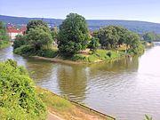
View from Questenberg slope over the origin of the Weser to Untere Tanzwerder ; in the background the Kaufunger forest

View from Tanzwerder down the Weser from the Weserstein on the Untere Tanzwerder to the Weser Bridge ; behind the Reinhardswald
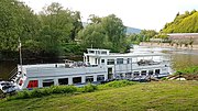
Passenger ship Weserstein at the jetty of the Lower Tanzwerder


literature
- Karl Brethauer : Dog races on the Tanzwerder . In: Münden. Collected Essays. First episode. Publisher Hans Fiedler, Hann. Münden 1984, pp. 98-99.
Individual evidence
- ↑ a b c d e f g h Length and area information using the Measure distance function on Google Maps
- ↑ The new Lion Bridge in Münden is floating bit by bit , from April 15, 2015, accessed on February 16, 2016, on hna.de.
- ↑ New Lion Bridge over the Fulda is free for traffic , October 1, 2015, accessed on February 16, 2016, on hna.de.
- ^ New construction of the Löwenbrücke in Hann. Münden: Start at the beginning of October , from September 11, 2014, accessed on February 16, 2016, at hna.de.
- ↑ a b Hann. Münden: Pionierbrücke , accessed on February 16, 2016 at structurae.de
- ↑ The Intercultural Garden , accessed on February 16, 2016, at hann.muenden.de
- ↑ Fish trail Fulda-Werra-Weser , inauguration of the fish trail ... , from April 19, 2004, accessed on February 16, 2016, at hann.muenden.de
Web links
- Tanzwerder (short description), at hann.muenden-tourismus.de
- Tanzwerder - Weserstein , 360-degree panorama picture (Flash / HTML5 ), on teschner-multimedia.de