
Bloomer Werder


The Blümer Werder is a narrow river island of the Werra on the edge of the old town of Hann. Münden in southern Lower Saxony . The under monument protection standing Werder is exclusively as a small garden area with plots and garden huts used. It is named after the historical suburb of Blume opposite and is located near the confluence of the Werra and Fulda rivers to the Weser .
description
The river island has a length of about 850 meters with a maximum width of 65 meters. It lies in the floodplain of the confluence of the Fulda and Werra rivers. Originally, this was a swampy landscape in which elevated areas such as the Blumer Werder, the Doktorwerder , the Tanzwerder and the Eselwerder have formed due to the flooding of the river . Werder is located on the B 80 between the Welfenschloss Münden and the historic suburb of Blume. The island is accessible to pedestrians via a makeshift pontoon bridge , which is only available in the summer months. There is no access in winter, as the island is temporarily inundated due to flooding of the Werra.

In 2011, the city of Hann. Thoughts about demolishing the allotment huts because they are in the flood protection area. In 2014 the city announced that it would draw up a development plan for the existing building stock. After that, the huts should not exceed a certain size and a five-meter-wide edge of the bank should be created.

The pontoon bridge that exists in the summer is the only access to the Blümer Werder
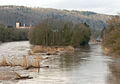
Eastern tip of the Werder in winter with high water levels in the Werra
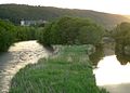
Eastern tip in summer with reeds


Web links
Individual evidence
- ↑ Blümer Werder: Temporary bridge comes away in Hessische / Niedersächsische Allgemeine from October 28, 2010
- ↑ Huts in Hann. Mündener Blümer Werder should stay with StadtRadio Göttingen from June 8, 2011
- ↑ Blümer Werder in the Werra: Plans for the island of allotment gardeners in Hessische / Niedersächsische Allgemeine from March 10, 2014
Coordinates: 51 ° 25 ′ 6 " N , 9 ° 39 ′ 29.1" E