Niedermalkalden
|
Niedermalkalden
City of Schmalkalden
Coordinates: 50 ° 42 ′ 57 ″ N , 10 ° 22 ′ 31 ″ E
|
|
|---|---|
| Height : | 262 m |
| Residents : | 700 |
| Incorporation : | June 30, 1994 |
| Incorporated into: | Wernshausen |
| Postal code : | 98574 |
| Area code : | 036848 |
|
Location of Niederschmalkalden in Schmalkalden
|
|
|
Partial view with church (2012)
|
|
Niedermalkalden is a district of the town of Schmalkalden in the district of Schmalkalden-Meiningen (Thuringia). Until it was incorporated into Wernshausen on June 30, 1994, Niederschmalkalden was an independent municipality. Together with Wernshausen and Helmers, Niederschmalkalden has been part of Schmalkalden since December 1, 2008.
location
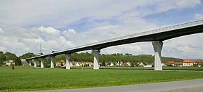
Niedermalkalden is located in the valley of the Schmalkalde , just before it flows into the Werra . The state road 1026 leads through Niederschmalkalden from Schmalkalden in the east to federal road 19 in the Werra valley and on towards Dermbach . In addition, the Zella-Mehlis-Wernshausen railway runs through the town. The closest cities are Schmalkalden (about six kilometers east) and Meiningen (about 18 kilometers south). A bypass is under construction for federal highway 19 , partly on the route of the unfinished Reichsautobahn route 85 , in the course of which the valley of the Schmalkalde was spanned with a 630 meter long bridge at Niederschmalkalden .
history
The place was first mentioned in 1325 as Nidern Smalcaldin , when it came from the possession of the Frankenstein dynasty to the Counts of Hennberg . The Hennebergers had a Landwehr built as a border fortification. It all began with the double moat at the Todenwarth castle ruins , which served as a customs castle . In the 15th century, Niederschmalkalden came from the rule of Schmalkalden to the Henneberg office of Wasungen . The Niedermalkalden jurisdiction was still exercised by the Cent Schmalkalden until 1619.
In the 16th century there was a blast furnace for iron processing on the outskirts. It was later converted into bar and wire production. In the 18th century it was a poor village of day laborers and farm workers. The industrialization brought Niedermalkalden a first boom in the 19th century. A worsted spinning mill was established in the village as a branch of the factory operated in the Glücksbrunn district of Schweina . In 1881 the worsted spinning mill in the neighboring village of Wernshausen took over this part of the business. The historic buildings of the worsted spinning mill, which was shut down after the fall of the 1990s, were demolished in 2009.
Web links
Individual evidence
- ↑ StBA: Changes in the municipalities in Germany, see 1994
- ↑ StBA Area: changes from 01.01. until December 31, 2008
- ↑ " 630 meters across the valley ." At www.insuedthueringen.de . Accessed May 16, 2012.
- ↑ Between Ruhla, Bad Liebenstein and Schmalkalden. Results of the local history inventory in the areas of Ruhla and Schmalkalden (= values of our homeland . 48). Akademie-Verlag, Berlin 1989, ISBN 3-05-000378-2 , pp. 146–147.
- ↑ "The old spinning mill is in ruins ". On www.insuedthueringen.de . Accessed May 16, 2012.


