Mittelschmalkalden
|
Mittelschmalkalden
City of Schmalkalden
Coordinates: 50 ° 43 ′ 6 " N , 10 ° 23 ′ 56" E
|
|
|---|---|
| Height : | 273 m above sea level NN |
| Residents : | 1000 (2012) |
| Incorporation : | June 1, 1994 |
| Postal code : | 98574 |
| Area code : | 03683 |
|
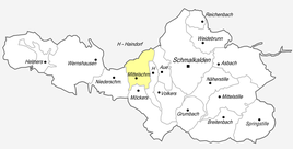
Location of Mittelschmalkalden in Schmalkalden
|
|
|
View from the south (2012)
|
|
Mittelschmalkalden is a district of the town of Schmalkalden in the district of Schmalkalden-Meiningen in Thuringia .
location
The street district of Mittelschmalkalden is located along state road 1026 in the Schmalkalde valley, surrounded by meadows and then forests. This state road connects the surrounding area with federal road 19 in the direction of Eisenach , which brings with it a flood of traffic.
history
The district was first mentioned as a village on February 26, 1289. He belonged to the office of Schmalkalden of the Hessian rule Schmalkalden .
On July 1, 1950, the previously independent communities of Aue and Haindorf were incorporated.
1000 inhabitants live in the district in 2012. In 1994 the village was incorporated into Schmalkalden. The children of the 1st to 4th grades from the area attended a half-timbered elementary school here until 2006 .
Personalities
- Hugo Simon (1909–1945), resistance fighter
- Heinz Roth (* 1931), Colonel of the Ministry for State Security (MfS) and head of Department XII (Central Information / Storage) of the MfS
literature
- Robert Eberhardt: Chronicle Lower Schmalkaldetal. Haindorf, Mittelschmalkalden, Aue, Volkers, Möckers . R. Eberhardt, Schmalkalden 2007.
Web links
Individual evidence
- ^ Wolfgang Kahl : First mention of Thuringian towns and villages. A manual. 5th, improved and considerably enlarged edition. Rockstuhl, Bad Langensalza 2010, ISBN 978-3-86777-202-0 , p. 182.
- ↑ Mittelschmalkalden on the website of the city of Schmalkalden. Retrieved May 15, 2012.

