Winne (broads)
|
Winne
Breitungen / Werra municipality
Coordinates: 50 ° 45 ′ 25 ″ N , 10 ° 21 ′ 45 ″ E
|
|
|---|---|
| Height : | 270 m above sea level NN |
| Postal code : | 98597 |
| Area code : | 036848 |
|
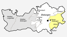
Location of Winne in Breitungen / Werra
|
|
|
On the northern outskirts of Winne
|
|
Winne is a hamlet-like district of Breitungen / Werra in the Schmalkalden-Meiningen district in Thuringia .
location
Winne is located southeast of Breitungen on the state road 1024 , which connects Fambach with Trusetal , in a funnel-shaped side valley of the Werra , on the right and left wooded hill country with some terraces. Bundesstraße 19 passes in the west . This is followed by Breitungen and the Werraniederung.
history
The first documentary mention of the agricultural property that was settled at that time takes place on September 13th, 1137. A few individual farms were part of Breitungen, which then developed further. That includes Winne. The court belonged to the office of Herrenbreitungen in the Hessian rule Schmalkalden and only came to Thuringia in 1944.
Personalities
- Tamara Danz (1952–1996), singer and front woman of the group Silly .
Web links
Individual evidence
- ^ Wolfgang Kahl : First mention of Thuringian towns and villages. A manual. 5th, improved and considerably enlarged edition. Rockstuhl, Bad Langensalza 2010, ISBN 978-3-86777-202-0 , p. 316.
- ^ History of the community . Retrieved from the Internet on June 3, 2012.

