Knollbach
|
Knollbach
Breitungen / Werra municipality
Coordinates: 50 ° 45 ′ 12 ″ N , 10 ° 18 ′ 47 ″ E
|
|
|---|---|
| Height : | 275 m above sea level NN |
| Incorporation : | 1938 |
| Postal code : | 98597 |
| Area code : | 036848 |
|
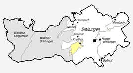
Location of Knollbach in Breitungen / Werra
|
|
|
Partial view (2012)
|
|
Knollbach is a hamlet-like district of Breitungen / Werra in the Schmalkalden-Meiningen district in Thuringia .
location
Knollbach is located west of Breitungen and the Werra in a plateau-like floodplain to Craimar . The place is connected to the traffic via a road to the hamlet. To the west on the slopes and on the hills there is forest.
history
On May 10, 1183, the settlement of Knollbach was first documented. A few settled individual farms belonged to Breitungen, which then developed further. Knollbach is one of them. In 1938 Knollbach was incorporated into Breitungen.
Web links
Commons : Knollbach - Collection of images, videos and audio files
Individual evidence
- ^ Wolfgang Kahl : First mention of Thuringian towns and villages. A manual. 5th, improved and considerably enlarged edition. Rockstuhl, Bad Langensalza 2010, ISBN 978-3-86777-202-0 , p. 149.
- ↑ History of the community on the official website ( Memento of the original from March 7, 2014 in the Internet Archive ) Info: The archive link has been inserted automatically and has not yet been checked. Please check the original and archive link according to the instructions and then remove this notice. . Retrieved June 3, 2012.

