Hoher Hagen (Dransfeld)
| High Hagen | ||
|---|---|---|
|
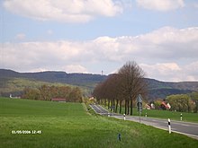
View over Jühnde northwest to the Hohen Hagen |
||
| height | 492.5 m above sea level NHN | |
| location | Boundary of the areas of the municipalities of Dransfeld , Jühnde and Scheden in the combined municipality of Dransfeld , Göttingen district , Lower Saxony ( Germany ) | |
| Mountains | Dransfeld city forest | |
| Coordinates | 51 ° 28 '31 " N , 9 ° 45' 52" E | |
| Topo map | DTK25 sheet 4524 Scheden | |
|
|
||
| Type | volcano | |
| rock | Basalt breakthrough from alkali-olivine-basalt , which leads to fist-sized xenolites of peridotite (" olivine bombs ") | |
| Age of the rock | Middle Miocene | |
| Last eruption | about 12 million years ago (according to K-Ar regulations ) | |
| Development | Gauss tower observation tower | |
| particularities | Highest mountain in the Dransfeld city forest | |
|
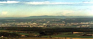
View from Hohen Hagen to the northeast over Göttingen to the Harz Mountains |
||

The Hohe Hagen is about 492.5 m above sea level. NHN high mountain of volcanic origin in the near Dransfeld located Dransfelder city forest , a Mittelgebirgszug in southern Lower Saxony Göttingen district . It is the highest point in the Dransfeld area.
geography
location
The Hohe Hagen rises about halfway (as the crow flies ) between Göttingen in the northeast and Hann. Münden in the southwest in the Münden Nature Park - in the areas of the city of Dransfeld (about northwest and northern parts), where its summit is also located, the municipality of Jühnde (eastern flank) and the municipality of Scheden (southern flank). The summit of the mountain on the eastern edge of the Dransfeld city forest is about 3 km south of the Dransfeld core town. The source of the Auschnippe lies somewhat northwest of the Hohen Hagens between the elevations of Brunsberg ( 480.2 m ) in the east and Hengelsberg ( 463 m ) in the west . The Dramme tributary Häger Graben rises on the northeast flank .
Natural allocation
The Hohe Hagen belongs in the natural spatial main unit group Weser-Leine-Bergland (No. 37), in the main unit Sollingvorland (371) and in the subunit Südliches Sollingvorland (371.1) to the natural area Dransfeld plateau (371.15).
Mountain height
According to the uppermost contour line , which can be seen on topographical maps in the area north-north-west of the Gauss tower at Haus Hoher Hagen, the Hohe Hagen is about 492.5 m high. Its height is occasionally 508 m above sea level. NN specified; this number still appears in more recent maps. However, the summit, which originally reached this height , was removed in the course of basalt mining in the 19th and 20th centuries - presumably after the collapse of the Old Gauss Tower , which was built at a height of around 506 m, on November 14, 1963 . Sometimes around 480 m are mentioned as the mountain height. The pointed curve of the Hoher-Hagen-Strasse south of the Gauss tower (see Traffic and Hiking ) is at an altitude of 478.3 m , and south of the basalt quarry there is a 482.9 m high point on a forest path branching off .
After the Haferberg ( 580.4 m ), the two equally high Steinberg mountains (Großer and Kleiner Steinberg ; 541.8 m and 541.9 m high) and other mountains in the Lower Saxony part of the Kaufunger Forest and in the Münden Nature Park, the Hohe Hagen counts to the highest mountains in the southern tip of the state of Lower Saxony.
Geology and mining
The Hohe Hagen is one of the northernmost volcanoes in Germany. It contained minable amounts of volcanic rock, which has its origin in the tertiary period . The mining of basalt rock on the Hohen Hagen is documented from 1825/26. The quarry was expanded as early as 1856, and the most important period of basalt mining began in the 1920s. The basalt quarry area at that time was over 11 hectares. The basalt deposits on the Hohen Hagen were exhausted, so mining was stopped in 1971.
The history of the basalt quarry can be experienced since autumn 2004 through a geology and mining trail.
Protected areas
Parts of the landscape protection area (LSG) Weserbergland-Kaufunger Wald ( CDDA no. 325317; 1989; 285.018 km² ) lie on most of the Hohe Hagens . On its south and west flanks are those of the LSG beech forests and limestone grasslands between Dransfeld and Hedemünden (CDDA no. 555547221; 2011; 16 km²) and the fauna-flora-habitat area beech forests and limestone grasslands between Dransfeld and Hedemünden (FFH no . 4524-302; 14.96 km²).
history
In the course of his summer trip to Göttingen, Bad Pyrmont and Kassel, Johann Wolfgang von Goethe climbed the Hohen Hagen on August 14, 1801. He wrote about this in his diary:
“2 o'clock in the afternoon in Dransfeld. Visited the basalt quarries there and climbed the Hohen Hahn (flat Hauen Hohn), from which one can enjoy the most beautiful view. So one sees, for example, the Brocken, the old Hanstein, the Berlepsch Castle, two of the same in their ruins, Göttingen, with the surrounding villages, the Hainberg behind it, the woody Harz Mountains, then Northeim and the old Plessburg, further to the area of Holzminden and Höxter. "
As part of the survey of the Kingdom of Hanover ( Gaußsche Landesaufnahme ) carried out by Carl Friedrich Gauß between 1818 and 1826 by triangulation , Gauß used the Hohen Hagen as a triangle point for his "large triangle" Hoher Hagen - Brocken - Großer Inselsberg . This triangle with side lengths of 68 km (Hoher Hagen - Brocken), 84 km (Hoher Hagen - Großer Inselberg) and 106 km (Brocken - Großer Inselberg) was the basis for linking numerous regional survey data.
Since Gauss already considered a non-Euclidean geometry to be possible at that time and he knew that the axiom of parallels was dispensable, the legend developed for the measurement of the large triangle that Gauss had empirically on the occasion of the Hanover land surveying after a deviation of the sum of angles from the Euclidean value of 180 °, as is the case with this triangle formed by the Hohen Hagen, the Brocken and the Inselberg. The measurement by Gauss has been proven, but the above-mentioned assumption about motivation is uncertain. Max Jammer wrote about the result of this Gaussian measurement:
"It hardly needs to be specifically stated that he did not discover any deviation of 180 ° within the error limit and from this he drew the conclusion that the structure of real space is, as far as experience allows a statement, Euclidean."
Buildings
Gauss tower
From 1909 to 1911, the 32.3 m high Gauss Tower (→ Old Gauss Tower ) was built from basalt rock on the Hohen Hagen . In 1963 it collapsed due to loosening of the soil caused by explosions in the neighboring quarry. The tower was not rebuilt.
In 1964, the 51 m high New Gauss Tower made of reinforced concrete, a 51 m high broadcasting and viewing tower with a panorama restaurant , was built on the neighboring site . From its viewing platform at a height of 528 m , the all-round view not only falls over the Dransfelder Stadtwald , but also to Solling , to Göttingen with the Göttingen Forest and the Harz Mountains behind it, as well as to the Hohen Meißner , Kaufunger Wald , Habichtswälder Bergland and Bramwald with the beyond Reinhardswald .
House Hoher Hagen
On the (today's) summit region of the Hohen Hagens, about 180 m north-north-west of the Gauss tower, in the middle of the forest, is the Haus Hoher Hagen , a former mountain inn built in 1914, which has been used as a school camp and educational facility since 1982. The sponsors are the Friends of the Georg Christoph Lichtenberg Comprehensive School Göttingen, the Otto Hahn Gymnasium Göttingen and the Association for Extracurricular Education. V. The self-catering house has 40 beds and is rented to groups.
freetime and sports
Hare milker run
The Dransfelder Hasenmelkerlauf , a 10,900 m long Volksberglauf, which leads from Dransfeld over the Hohen Hagen , has been taking place on May 1st .
Cycling
Since 2004, the road leading over the Hohen Hagen (see traffic and hiking ) has been running a section of the route with a mountain rating in the third category of the international tour of Lower Saxony for professional cyclists and, since 2005, the everyone's race with start and finish in Göttingen . The Hohe Hagen is the local mountain of the RSC Hoher-Hagen cycling club, which is committed to popular sport for mountain bikers and racing cycling around the Hohe Hagen.
Traffic and walking
A narrow road leads to the Hohen Hagen - past its summit region and the Gauss tower - at least in the Dransfeld area it is called Hoher-Hagen-Strasse and also Zum Hohen Hagen and on the north ascent it has a gradient of over 10% in sections. In Dransfeld it branches off from the federal highway 3 and leads south up the mountain, to then run northeast to the state road 559 (Dransfeld – Jühnde). The European long-distance hiking trail E6 runs over the mountain , which turns into the normal route and one to Hann. Münden leading variant divides. In addition to local walking and hiking trails (geology path ) that lead over, the mountain is also a station on the student path between the towns of Rosdorf and Scheden and the Loccum – Volkenroda pilgrimage route between the towns of Dransfeld and Jühnde .
See also
literature
- Friedel Rehkop: City of Dransfeld. A historical look back from the 19th century to the early days . Volume 1. Geiger-Verlag, Horb am Neckar 1999, ISBN 3-89570-561-6 , pp. 196-200, 352-360, 387-397.
Web links
- High Hagen . wiki-goettingen.de
- Haus Hoher Hagen - school camp, conference center, educational facility . haus-hoher-hagen.de
- Dransfelder Hasenmelkerlauf . Endurance sports club (ASV) Velo-Venezia Dransfeld e. V., on hasenmelker-lauf.de
Individual evidence
-
↑ a b c The Hohe Hagen in a section of the official map 1: 5000 (AK5), topographical map of the State Office for Geoinformation and Land Surveying Lower Saxony (LGLN) in Geolife.de Navigator of this State Office.
See also:
Article Hoher Hagen in the Göttingen Wiki of the Göttinger Tageblatt GmbH & Co. KG, in which the mountain height is specified as 493.5 m (accessed on September 3, 2013) and the mountain as the “fourth highest” elevation in southern Lower Saxony referred to as. - ↑ a b The Hohe Hagen in a section of the topographical map 1: 25,000 (DTK25) of the State Office for Geoinformation and Land Surveying Lower Saxony (LGLN) , in Geolife.de Navigator of this State Office.
- ↑ Josef Paul: The Hohe Hagen near Göttingen: a tertiary volcano and its surroundings (excursion A on April 2, 2013). In: Annual reports and communications from the Upper Rhine Geological Association . New volume 95, 2013, ISSN 0078-2947 , doi: 10.1127 / jmogv / 95/2013/11 , pp. 11–25, here: 13, 17 ( summary ; same as PDF (66.0 KiB); with address of the author).
- ^ Hans-Jürgen Klink: Geographical land survey: The natural space units on sheet 112 Kassel. Federal Institute for Regional Studies, Bad Godesberg 1969. → Online map (PDF; 6.9 MB)
- ↑ Diercke World Atlas . Westermann, 5th edition 2002. ISBN 978-3-14-100600-1
- ↑ Hoher Hagen - Gauss Tower . ( Memento of the original from June 2, 2013 in the Internet Archive ) Info: The archive link was inserted automatically and has not yet been checked. Please check the original and archive link according to the instructions and then remove this notice. stadt-dransfeld.de; Retrieved September 6, 2013
- ↑ a b Map services of the Federal Agency for Nature Conservation ( information )
- ↑ Johann Wolfgang von Goethe : Diary (from 1801), Weimar Edition III 3, p. 33f.
- ↑ Erhard Scholz thinks it is quite possible that Gauss thought of it, see: Erhard Scholz: CF Gauß 'Precision measurements of terrestrial triangles and his considerations on the empirical foundation of geometry in the 1820s. Submitted on September 29, 2004 ( arxiv : math / 0409578 ). Gauss himself expresses himself in a letter to Olbers dated March 1, 1827, quoted by Walter Kaufmann-Bühler: Gauß - a biographical study , Springer-Verlag, 1987, p. 97, to the effect that the measurement errors for such a determination of deviations be great.
- ↑ Max Jammer: The problem of space . Darmstadt 1960, p. 164


