Schlotheimer Graben
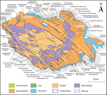
The Schlotheimer Graben , named after the place Schlotheim , is the rift valley of the Hercynian fault zone , ie from northwest to southeast running Schlotheimer fault zone , a geological fault in the northwest of the Thuringian Basin in the districts of Unstrut-Hainich-Kreis and Kyffhäuserkreis .
course
The Schlotheimer Graben accompanies the upper reaches of the Notter from Obermehler to Schlotheim , from there upstream the Marolteroder Bach via Marolterode to the headwaters and further southeast downstream the Schambach- Oberlauf Fernebach from the headwaters near Blankenburg to Bruchstedt . It is flanked in the lower two sections by the Heilinger Heights , which are up to 368 m high . The north-westerly section, on the other hand, extends to the south-eastern slope of the Dün and is bordered to the west by the Volkenroder forest ( 364 m ) north of Volkenroda .
Geological structure
The anticline structure around the Schlotheimer Graben is geologically known as the Schlotheim-Tennstedter Gewölbe .
The interior of the Schlotheimer Graben forms a ditch made of loess and loess derivatives , in the central and north-western area also silt and clay stones , which is bordered by two parallel fault lines. Apart from the somewhat higher headwaters of Marolteroder Bach and Fernebach, the Upper Muschelkalk of the Heilinger Heights or the Tennstedter Gewölbe and the Volkenroder Wald fall off in a rugged stratification (see also the section there ).
More global mapping
The Schlotheim fault zone forms the northwestern part of the Schlotheim-Leuchtenburg fault zone , which Hercynically divides the Thuringian Basin in two , but only continues about 35 kilometers away on the southwest slope of the Ettersberg in order to reach its core area via Weimar to southwest Jena .
Individual evidence
- ^ Hydrogeological map of Thuringia from the Thuringian State Institute for Environment and Geology - PDF, 4.37 MB
Web links
- D. Franke: Regionalgeologie Ost - Geological online lexicon for East Germany
Coordinates: 51 ° 13 ′ 39 " N , 10 ° 41 ′ 7.8" E
