Heldrabach
|
Heldrabach Haselbach (in the upper and middle reaches) |
||
|
The Heldrabach, here called Haselbach, in Wendehausen |
||
| Data | ||
| Water code | EN : 4174 | |
| location | Unstrut-Hainich-Kreis ( Thuringia ), Werra-Meißner-Kreis ( Hesse ), Germany | |
| River system | Weser | |
| Drain over | Werra → Weser → North Sea | |
| source | near Diedorf in the Upper Eichsfeld | |
| muzzle | at Heldra in the Werra coordinates: 51 ° 7 ′ 29 ″ N , 10 ° 11 ′ 51 ″ E 51 ° 7 ′ 29 ″ N , 10 ° 11 ′ 51 ″ E |
|
| Mouth height | approx. 168 m above sea level NN
|
|
| length | approx. 11.1 km | |
| Catchment area | 25.598 km² | |
| Drain |
MQ |
220 l / s |
| Right tributaries | Walsbach | |
| Small towns | Wanfried | |
| Communities | Südichsfeld | |
|
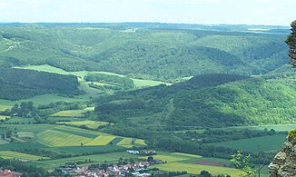
View from Heldrastein to the lower valley of the Heldrabach, where Kleintöpfer once lay (center); in front the Heldra located on the Werra |
||
The Heldrabach (or Heldra ), also called Haselbach (or Hasel ) in the upper and middle reaches , is an approximately 11.1 km long right or north-eastern tributary of the Werra in the Unstrut-Hainich district in western Thuringia and in the Werra-Meißner -Circle in the northeast of Hesse ( Germany ).
Course and catchment area
The stream rises as Haselbach in Thuringia in the Upper Eichsfeld in the Eichsfeld-Hainich-Werratal Nature Park . Its source area is located in the municipality Südeichsfeld counting Diedorf .
In the upper and middle reaches of the stream, which separates the northern Wanfrieder Werra heights from the southern Falkener Platte , flows along state road 1019 to and through the village of Wendehausen , which also belongs to the municipality of Südeichsfeld.
In the adjoining Thuringian area of its lower reaches, the flowing water created a nearly 300 m wide breakthrough valley between the Mainzer Köpf ( 447 m above sea level ) in the north, the Töpferberg ( 290.3 m above sea level ) in the southwest and the mountain Adolfsburg ( 378, 7 m above sea level ) in the southeast. Where the Bachtal opens to the Werra valley, about 300 m from the Thuringian-Hessian border, were the Kleintöpfer estate and the brickworks of the same name . The water mill Kleintöpfer stood close to the border on the Thuringian side and the field mill on the Hessian side ; both were grinders . The buildings in Thuringia, which belonged to the town of Treffurt in the Wartburg district , were demolished in 1964 due to an order by the GDR .
After crossing the state border and leaving the Eichsfeld-Hainich-Werratal nature park, the brook - from now on called Heldrabach in the Hessian part of its lower reaches - flows along the L 3244. Then it crosses under the federal road 250 and the Werra valley cycle path to after flowing through the Wanfried belonging village Heldra at about 168 m above sea level. NN to flow into the Werra . The mountain Heldrastein ( 503.8 m above sea level ) rises south-south-west across the river from its mouth , from whose observation tower you can see the Heldrabach valley, among other things.
The catchment area of the Heldrabach is 25.598 km².
Individual evidence
- ↑ a b Map services of the Federal Agency for Nature Conservation ( information )
- ↑ a b Length of the Heldrabach including Sählenbach and Beek measured by geopath on google earth
- ↑ a b Water map service of the Hessian Ministry for the Environment, Climate Protection, Agriculture and Consumer Protection ( information )
- ↑ Volker Große, Klaus Herzberg: Treffurt, Mühle Kleintöpfer . In: Maik Pinkert (Ed.): Mühlen im Obereichsfeld. A compendium . Eichsfeld-Verlag, Heiligenstadt 2008, ISBN 978-3-935782-13-5 , p. 323 .

