Hildebrandshausen
|
Hildebrandshausen
Rural community of Südeichsfeld
Coordinates: 51 ° 12 ′ 1 ″ N , 10 ° 12 ′ 52 ″ E
|
|
|---|---|
| Height : | 303 m |
| Area : | 6.08 km² |
| Residents : | 414 (Dec. 31, 2010) |
| Population density : | 68 inhabitants / km² |
| Incorporation : | December 1, 2011 |
| Postal code : | 99976 |
| Area code : | 036027 |
|
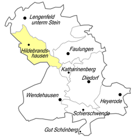
Location of Hildebrandshausen in Südeichsfeld
|
|
|
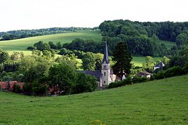
Holy Cross Catholic Parish Church
|
|
Hildebrandshausen is a village near the Hessian-Thuringian border in the Unstrut-Hainich district in Thuringia . Since December 1, 2011, the formerly independent municipality has been part of the rural municipality of Südeichsfeld . The community previously belonged to the Hildebrandshausen / Lengenfeld unterm Stein administrative community .
geography
Geographical location
Hildebrandshausen is located about 17 kilometers west of the district town of Mühlhausen in Obereichsfeld and its district is part of the Eichsfeld-Hainich-Werra Valley Nature Park .
Mountains and elevations
The place is located east of the distinctive Konstein - Plesse - Keudelskuppe along the state border, the northern part of the Wanfrieder Werrahöhen . On the Keudelskuppe ( 484.7 m above sea level ), still on the Thuringian side, was the ancestral castle of the noble family von Keudell in the Middle Ages ; the Keudell estate was built on the central slope, but is now a desert . Hildebrandshausen still surrounds the mountains and heights Heiligenberg ( 436 m above sea level ), Dünberg ( 440.2 m above sea level ), the Konstein is the highest point in Hildebrandshausen ( 455.2 m above sea level ).
Waters
The Rosebach flows through the village - in the village of Kirchbrunnen , a tributary of the Frieda , which in turn flows into the Werra .
Neighboring places
In the north of Hildebrandshausen lies Lengenfeld unterm Stein , to the east there are Faulungen and Wendehausen . Wanfried is to the south and Geismar to the west .
history
The name Hildebrandshausen indicates a foundation during the reign of the Franks between 500 and 800 AD. During this time, the Christianization of the pagan population began, for whom the neighboring Hülfensberg - as Heilger Berg - has a special significance. Because of the topographical conditions, Hildebrandshausen was very closely connected to the neighboring town of Lengenfeld / Stein.
Hildebrandshausen and the majority of the neighboring towns belonged to the administrative district of Stein Castle , only four kilometers away , after its destruction, to the later built Bischofstein Castle near Lengenfeld unterm Stein . Stein Castle initially belonged to the fortifications of the Archdiocese of Mainz and at times passed to the Lords of Plesse . The Archbishop of Mainz did not acquire it back for a considerable price until 1326, but had to share the rulership of the castle with the Landgrave of Thuringia (for contractual reasons) . Other castles in the vicinity of the place are the Keudelskuppe and the Spindelsburg as well as the Wallburg Konstein.
In 1358 it was first mentioned as a foundation to the Archdiocese of Mainz . A typical street village developed . Until 1792, jurisdiction over the village lay with the von Keudell lords . Men from the village took part in the Peasants' War in 1525. As a result of the Counter-Reformation led by Mainz, the population remained / became Catholic. In the Thirty Years' War the number of “hearths” fell to almost half. 46 inhabitants died in the plague and famine years of 1771–73. In 1802 the rule of Mainz was ended. From 1807 to 1813 part of the Kingdom of Westphalia , the village was assigned to the Kingdom of Prussia , administrative district Erfurt, district Heiligenstadt after the Congress of Vienna .
Around 1840 the village had 731 Catholic and 2 Protestant residents. 108 houses and 65 stables and barns were mentioned. A teacher taught the 85 boys and 67 girls who had to attend school. The population lived in poor conditions. At that time, in Hildebrandshausen, the wool combing and spinning mill was mainly part of the business as a supplier for the weaving villages in the neighborhood. Artisanal weaving and textile production was widespread in Eichsfeld; only 37 primitive wool looms and two linen weavers were found in the village. The overview lists four shoemakers, two tailors, a wheelwright, a bricklayer, a blacksmith, a white binder, a house butcher , three breweries, three servants and four maids as other commercial and craft businesses . In the village, at the foot of the Kirchbrunnen -Quellbach stream, there were two grinding mills. Two grocers (victuals) obtained the food they needed from outside. The livestock consisted of 38 horses, 131 cattle, 220 sheep, 31 goats and 70 pigs. The village corridor comprised 1780 acres , of which the agricultural area comprised 1390 acres of arable land, 25 acres of garden land, 18 acres of meadow and 17 acres of pasture. In addition, 123 acres of community forest and 207 acres of fallow land were named. The yield from the fields was estimated to be low. Fruit growing had started with apples, cherries and plums.
In the 19th century, people in Hildebrandshausen were mainly engaged in "fast-paced", hand-wool combing and agriculture, or they worked outside of it. In 1862 the village already had 850 inhabitants.
The current church was built in 1860. In 1869 the former Junker 's house was converted into a rectory . In 1907 the place got a drinking water supply, and in 1919 it was connected to the power station.
With the construction of the railway to Lengenfeld / Stein, the transport links of the place had been improved.
In the First World War Hildebrandshausen mourned 23 Fallen. During the Second World War , more than 100 people evacuated from areas at risk of air warfare had to be admitted in 1943, many displaced persons during and after the end of the war. 52 local men did not return from the war.
After the US occupation, Hildebrandshausen became part of the SBZ and the restricted area on the border with Hesse in July 1945 . The land reform and the settlement of new farmers followed. In 1952, more than 100 residents were expelled from the town as part of the “ Vermin campaign ”, and in 1961 a much smaller similar campaign took place. After 1945, the place also lost many inhabitants by fleeing the Soviet occupation zone and the GDR . In 1954 the LPG "Banner of Peace" was founded ("breakthrough for building socialism"), in 1960 the last individual farmers had to join. A barracks for the border troops was built. Community services such as the creation of a sewer system were provided in the “National Reconstruction Works”.
With the opening of the border, Hildebrandshausen was freed from its constriction. The current townscape is determined by a pleasingly large number of well-kept half-timbered houses.
On December 1, 2011, the Hildebrandshausen community merged with three other communities to form the new rural community of Südeichsfeld.
Good Keudelstein
The lords of Keudell , who ruled the village from a small castle and then from their manor, played a major role in local history . Accordingly, they were also attacked in the Peasants' War in 1525. At the foot of the Keudelskuppe, the Keudell had the Keudelstein estate built from 1583 to 1669 on the site of the former Vorwerkes . A magnificent, three-story half - timbered castle belonged to it . The interior features beautiful fireplaces and richly painted wooden ceilings. The estate and castle were completely intact in 1945 when the last owner, Alexander von Keudell, was expropriated without compensation. In 1948, the demolition of the castle for the "extraction of building materials" began on the basis of the notorious Order 209 of the Soviet military administration. The farm buildings were still used, but the area was neglected. In 1978 the GDR border troop leadership ordered the complete demolition of the remnants of the manor near the zone border: free field of fire and removal of a possible hiding place for GDR refugees . Two courageous citizens recovered two portal figures of the castle from the rubble , which are today at the Marienkirche in Heiligenstadt.
mayor
The last honorary mayor Heinz Blümel (CDU) was re-elected on June 6, 2010. The current mayor is called Veit Görsdorf.
Daughters and sons of the church
- Charles Miller (1875–1951), American cyclist
- Horst Montag (* 1938), geodesist
Attractions
In the local area are the Catholic parish church Heilig Kreuz , initially a branch church of Lengenfeld / Stein, built in 1866 and today's rectory, in this function since 1869: former "Junkerhaus", then spinning mill. The former barracks of the NVA border troops at the lower end of the village reminds of the division of Germany, as does the location of the former Keudelstein estate in the area. The view from the Plesse is praised as a remarkable vantage point. The Plesseturm is on the Hessian side.
Others
As evidence of coarse folk humor, neck names and nicknames that characterize each village developed centuries ago . According to this, the Hildebrandshausen Fallbeine - also fullenbeine - lived here in the village - these were traders who moved far across the country to sell their goods. In Faulungen one speaks of Hubershäuser .
literature
- Thomas Bienert: Keudelstein Castle demolished in GDR times. In: Thuringian General. Extra, June 26, 2004
Individual evidence
- ↑ The Hülfensberg is only 5 kilometers (as the crow flies) away.
- ↑ Ed. Ulrich Harteisen, Ansgar Hoppe et al .: Das Eichsfeld. (Volume 79 of the series Landscapes in Germany. ) Verlag Böhlau , Vienna / Cologne / Weimar 2018, ISBN 978-3-412-22539-1 , p. 414.
- ↑ Carl August Noback : Detailed geographical-statistical-topographical description of the administrative district of Erfurt. Expedition of the Thuringian Chronicle, Erfurt 1841, p. 174 .
- ↑ almost twice as many as in 2008.
- ↑ StBA: Area changes from January 1st to December 31st, 2011
- ↑ Local elections in Thuringia on June 6, 2010. Elections for community and city council members. Preliminary results. Retrieved June 6, 2010 .
- ↑ Rolf Aulepp: Nicknames of the places and their residents in the Mühlhausen district. In: Eichsfelder Heimathefte. Vol. 27, No. 1, 1987, ISSN 0232-8518 , pp. 78-83.


