Flarchheim
|
Flarchheim
Rural community of Unstrut-Hainich
Coordinates: 51 ° 7 ′ 37 ″ N , 10 ° 28 ′ 52 ″ E
|
|
|---|---|
| Height : | 216 m above sea level NHN |
| Area : | 11.86 km² |
| Residents : | 417 (December 31, 2017) |
| Population density : | 35 inhabitants / km² |
| Incorporation : | 1st January 2019 |
| Postal code : | 99986 |
| Area code : | 036028 |
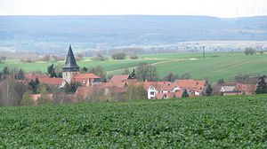
Flarchheim is a district of the rural community Unstrut-Hainich in the Unstrut-Hainich district in Thuringia .
geography
The place is at an altitude between 200 and 225 m above sea level. NN on the southeast edge of the Hainich . The Eichbach, which rises in the Hainich and is called Suthbach after the confluence with the Rispelbach, flows through the village from southwest to northeast and flows a little later on the right into the Unstrut . The place is embedded in a gently undulating hill country. The near-surface geological subsoil is formed by limestone and clays of the Keuper , on which a layer of loess is deposited. The fertile soils in the area are almost exclusively plowed. In the southwest, Flarchheim has a large share of the Hainich forests. The district extends there up to a height of 430 m above sea level. NN in the Flarchheimer Oberholz. In the north, Flarchheim has a share in the Seebach reservoir, the largest reservoir in the Unstrut-Hainich district.
history
The stone box from Flarchheim is a 1.55 m long and 1.02 m wide system of spherical amphora culture , which is now in the Mühlhausen local history museum.
The name ending -heim indicates a Franconian foundation . In 980 the place is mentioned for the first time in a document of the Fulda monastery . On January 27, 1080 the battle of Flarchheim took place in the course of the Saxon War of King Henry IV and Vratislav II of Bohemia .
The place belonged to the Electoral Saxon Office Langensalza until 1815 and after its cession to Prussia from 1816 to 1944 to the district of Langensalza in the province of Saxony .
At the beginning of the 1960s, Flarchheim had to sell a large part of its district in the west to the National People's Army in order to build up the "Weberstedt" military training area . The areas have belonged to the Hainich National Park since December 31, 1997 . Since then, Flarchheim has had the title “National Park Community”.
Since 1993, Flarchheim has been part of the Unstrut-Hainich administrative community , whose member communities, with the exception of Schönstedt, merged to form the Unstrut-Hainich rural community on January 1, 2019 .
politics
The council of the municipality of Flarchheim consisted of 6 council members and councilors.
- CDU 4 seats
- FW 1 seat
- FW DU 1 seat
(Status: local elections on June 27, 2004)
After the local elections in 2014, the local council consisted of 6 members.
The last honorary mayor Dietmar Ohnesorge was re-elected on June 6, 2010.
Others
- The symbol of Flarchheim was the avenue of pyramid poplars planted around 1909 on the local road to Oppershausen. The poplars were felled in 2007 for reasons of traffic safety and replaced in 2008 by an avenue of columnar oaks.
- As evidence of an often coarse folk humor, neck names and nicknames that characterize each village developed centuries ago . Accordingly, the Flarchheim hay ox lived here in the village .
Personalities
- Abraham Bock (1531–1603), court clerk of the Electorate of Saxony and owner of the manor, received an entitlement to the Rostsche Gut in 1565
- Friedrich Polack (1835–1915), educator
- Erich Röth (1895–1971), a. a. Thuringian dialect researcher
Individual evidence
- ↑ Thuringian Law and Ordinance Gazette No. 14/2018 p. 795 ff. , Accessed on January 13, 2019
- ↑ http://www.flarchheim.de/politik/lösungen.php?gremium=2680
- ↑ Local elections in Thuringia on June 6, 2010. Elections for community and city council members. Preliminary results. Retrieved June 6, 2010 .
- ↑ Rolf Aulepp: Nicknames of the places and their residents in the Mühlhausen district. In: Eichsfelder Heimathefte. Vol. 27, No. 1, 1987, ISSN 0232-8518 , pp. 78-83.

