Oberdorla
|
Oberdorla
Rural community Vogtei
|
||
|---|---|---|
| Coordinates: 51 ° 9 ′ 59 ″ N , 10 ° 25 ′ 10 ″ E | ||
| Height : | 227 m above sea level NHN | |
| Area : | 19.7 km² | |
| Residents : | 2118 (December 31, 2016) | |
| Population density : | 108 inhabitants / km² | |
| Incorporation : | December 31, 2012 | |
| Postal code : | 99986 | |
| Area code : | 03601 | |
|
Location of Oberdorla in Thuringia |
||
Oberdorla is a district of the Vogtei rural community in the Unstrut-Hainich district in western Thuringia ( Germany ).
history
The place-name ending -a indicates a Germanic foundation and the existence of a body of water. In fact, the foundation of the town was favored by the heavily pouring karst springs Kainspring and Melchiorbrunnen west of Oberdorla, which provided drinking water and driving power for seven mills . The main features of the site are still today:
- the market mill
- the Riethmühle
- the trial mill
- the basic mill
Oberdorla is first mentioned in a document in 805 in a deed of donation from Count Erpho von Bilstein .
In 987, Count Wigger von Bielstein built the St. Peter and Paul Church in Oberdorla, as well as a monastery attached to it , which gained wealth and power, and gave the Hainichwald to the people of Dorla. The head of the monastery was also archdeacon of the archdeaconate , one of the four north Thuringian church organizations that had quite a power. This monastery of the Augustinian Canons existed until 1472 and was moved to the city of Langensalza in 1487 . Oberdorla belonged to the Vogtei Dorla .
Two fires in 1666 and 1713 destroyed the place completely or almost completely.
On December 31, 2012, the municipality of Oberdorla merged with other municipalities of the Vogtei administrative community to form the new municipality of Vogtei.
mayor
The last honorary mayor, Winfried Bötticher , was re-elected on June 6, 2010.
coat of arms
Blazon : "In gold, a three-leaved green oak path with three black fruits."
The coat of arms symbolizes the wealth of forests in the municipality.
Culture and sights
Festivals
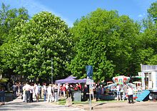
Traditional festivals are the Whitsun festival, the children's festival and the fair. The central fairground is always the Anger. Various customs are held especially at Pentecost . On Whit Monday, the Schößmeier , an approximately 3 meter high container made of wreaths decorated with flowers , is driven through the town. This custom has its origin in the Germanic flower festival. Before that, the syringe test takes place, in which the so-called accountants have to compete against the volunteer fire brigade . On Pentecost Tuesday the straw bear goes into action and is led through the town. At Pentecost, as in many places, a birch is set up as a Whitsun maize. The festival of the Oberdorla foliage cooperative takes place every year on the fairground lined with lime trees on the eastern edge of Hainich .
Architectural monuments
- The Anger:
- The largest village green in Thuringia with half a hectare is located in Oberdorla. It is lined with linden and chestnut trees and is the location of three monuments. The old court table is still completely intact and court was held six times a year. All male residents of the Vogteidörfer had to take part. To the right of the table is the memorial to the fallen, commemorating the soldiers from Oberdorla who died in the Franco-German War in 1870/71. The left of the table monument from 1886 commemorates the passage of the Vogteier in the summer of 1785-1786 to Vienna to Emperor Joseph II. Personally a petition to regulate the territorial issue of the Bailiwick to pass.
- The former collegiate church is not far from the village green. On the portal of the Romanesque church are the two heavily weathered but very impressive depictions of the apostles.
- The Oberdorlaer Heimatstuben :
- This facility is a local history museum, which was inaugurated in the former mayor's office on the Anger in 2007 and greatly expanded in 2008, with exhibitions on everyday village life, village and church histories and bailiwick customs. Issued are z. B. a model of the church and monastery of St. Peter and Paul, the old weather vane and a straw bear. The figure goes through the place on Pentecost Tuesday. The small museum also has a separate room for the composer and choir director Gunther Erdmann, who was born and raised in Oberdorla .
- The former "bath house"
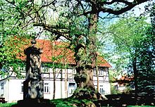
- It was located in the most beautiful half-timbered house in the town, which is now a listed building - Bahnhofstrasse 14 (built in 1732).
- The center of Germany :
- About 1,000 m east of the former Oberdorla train station is the geographic center of Germany in the Niederdorla district . A central festival is celebrated there every year.
- The Mallinden :
- The medieval court square “ Mallinden ” is located on the border between Ober- and Niederdorla on the road to Langula . It consists of three old linden trees which, according to tradition, were used for judgment. According to ancient scriptures, executions were also carried out here, for example on a woman who was burned at the stake as a witch.
Natural monuments
To the west of Oberdorla in the open corridor are the sinkhole sources " Kainspring ", " Melchiorbrunnen " and the Dittelhainsbrunnen . The Spittelbrunnen is an episodic spring, here was a medieval village Sprudelborn . The former sacrificial moor is a body of water that has resurrected after the peat mining ended; it was originally an extensive, water-filled and gradually silted up depression north of the Dorla places, where cult centers were already located in prehistoric times.
economy
Most of the land is used for arable farming and as grassland. Agricultural production facilities are located on the north-western edge of the village. With 1124 ha, Oberdorla in the west of the village has a share of the Hainich forest area . The Oberdorlaer Forest is directed by the forestry office Hainich-Werratal jointly by the foliage cooperative of the place as Book - Plenterwald used. Only small areas in Senkig are afforested with spruce and other conifers, which, however, are not native to Hainich. In the Oberdorla district in Hainich there is also a quarry , in which stone and gravel ( shell limestone ) is extracted above ground . In the southwest there is a larger tree nursery , in the east along the road between Mühlhausen and Eisenach there is an industrial area with a furniture store, commercial operations and a gas station. The starting point for the development of the industry was the train station in the east of the town.
traffic
The traffic connection is via the L 1016 between Mühlhausen and Eisenach, which passes east of the town. The Mühlhäuser Straße (L 2104) leads from the junction at the former Gunzelhof into the village. It turns right at the Anger in a westerly direction and leads from Oberdorla over the Hainich to Heyerode .
From 1911 to 1969 Oberdorla had a connection to the Mühlhausen – Treffurt railway line (“Vogteier Bimmel”), which connected the Mühlhausen basin with the Werra valley across the Hainich. Sections of the embankment and the old station building are still left of the old railway line.
In a north-south direction, Oberdorla is crossed by the Unstrut-Werratal cycle path . As the only regionally significant hiking trail, the Waagebalkenweg touches the place in the west, which connects Mühlhausen with the Great Hardt near Bad Langensalza along the eastern edge of Hainich.
natural reserve

Along a stone ditch on the country road between Oberdorla and Heyerode, there is a one kilometer long, narrow shaft drift with loose woodland, including numerous juniper bushes . The area has been protected as a natural monument on an area of 6.8 hectares since 1983 and continues to be grazed extensively with sheep . The largest proportion of the area is covered by lime-lean grasslands , some of which are rare species. The karst springs Kainspring and Melchiorbrunnen west of the village have been designated natural monuments since 1941.
Public facilities
- Seat of the administrative community Vogtei
- Bailiwick school Oberdorla
- Kindergarten "Vogteier Knirpse"
- Protestant kindergarten "Kinderschlösschen"
Sons and daughters of the place
- Konrad Kleinschmidt (1768–1832), missionary of the Moravian Brethren in Greenland , linguist and translator
- Simon Bang (1855–1928), high school councilor and non-fiction author
- Walter Karmrodt (1927–2017), local history researcher and author of non-fiction books on Thuringian history
- Manfred Böttcher (1933–2001), painter and graphic artist
- Gunther Erdmann (1939–1996), composer and choir director
- Joachim Böttcher (* 1946), painter and sculptor
literature
- Rolf Aulepp: The former collegiate church of Oberdorla . In: Mühlhauser contributions . Issue 10, 1987, ZDB -ID 14566-X , p. 15-36 .
- Paul Karmrodt: The bailiff's fight for old legal rights . In: Mühlhauser contributions . Volume 9, 1986, pp. 48-58 .
- Paul Karmrodt: Two bailiwick scientists in Greenland . In: Mühlhauser contributions . Issue 11, 1988, pp. 89-92 .
- Harald Rockstuhl (Hrsg.): Lexicon of personalities, writers and artists of the Bailiwick. With Kammerforst and Oppershausen. (Niederdorla, Oberdorla, Langula) . Rockstuhl, Bad Langensalza 2002, ISBN 3-936030-25-1 .
Individual evidence
- ↑ Renovation of the market mill in Oberdorla before completion. In: Thüringer Allgemeine , from October 28, 2015.
- ↑ a b Information board at the point of the center of Germany near Niederdorla.
- ↑ StBA: Area changes from January 1st to December 31st, 2012
- ↑ Local elections in Thuringia on June 6, 2010. Elections for community and city council members. Preliminary results. Retrieved June 6, 2010 .
Web links
- Oberdorla on gemeinde-vogtei.de


