Schlegelsberg (Obereichsfeld)
| Schlegelsberg | ||
|---|---|---|
|
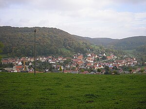
Laziness at the foot of the Schlegelberg |
||
| height | 461.2 m above sea level NHN | |
| location | Unstrut-Hainich-Kreis , Thuringia , Germany | |
| Mountains | Upper Eichsfeld , | |
| Coordinates | 51 ° 12 '4 " N , 10 ° 16' 7" E | |
|
|
||
| rock | Shell limestone | |
The Schlegelsberg is 461.2 m above sea level. NHN high mountain in the south of Eichsfeld in the Unstrut-Hainich district , Thuringia ( Germany ).
location
The Schlegelsberg is located on the edge of the Obereichsfelder Muschelkalkplatte in the western part of the Unstrut-Hainich district immediately north of Faulungen , southeast of Lengenfeld unterm Stein and southwest of Struth . The district town of Mühlhausen is about twelve kilometers to the east.
Natural classification
According to the natural spatial structure in the Kassel sheet, the mountain is part of the western upper area field (no.483.2), at the transition from the Kalteneberer step edge area (no.483.20) to the upper Friedatal area (no.483.21) of the north-western edge plate of the Thuringian basin (no.483).
According to the structure within Thuringia ( The Natural Spaces of Thuringia ), it is assigned to the Werrabergland-Hörselberge unit.
nature
The small mountain plateau is used for agriculture, while the northern, western and southern mountain slopes are forested (mixed beech forest with individual yew stands). To the northeast, the plateau flows smoothly into the mountain area of the Rode . Away from the highest point there are further elevations, in the west Der Stein (457.3 m) and in the southeast the Petersberg (up to 445 m). The mountain is bordered by the upper reaches of the Frieda in the north and its left tributary Faulunger Bach in the west and south.
The Schlegelsberg is located in the following protected areas:
- Eichsfeld-Hainich-Werratal Nature Park
- LSG Mühlhäuser Stadtwald
- NSG Klosterschranne and Faulunger Stein
particularities
At the level of the Muschelkalkplatte to the west, erosion has resulted in several rock formations, including the Faulunger Schranne , with seating for hikers, a large cross and a view of the Friedatal up to Gobert . A nature trail leads over the mountain and at the foot of the mountain above Faulungen there is a Marian grotto .
Individual evidence
- ↑ a b Map services of the Federal Agency for Nature Conservation ( information )
- ↑ Hans-Jürgen Klink: Geographical land survey: The natural space units on sheet 112 Kassel - Federal Institute for Regional Studies, Bad Godesberg 1969 → online map
-
^ Walter Hiekel, Frank Fritzlar, Andreas Nöllert and Werner Westhus: The natural spaces of Thuringia . Ed .: Thuringian State Institute for Environment and Geology (TLUG), Thuringian Ministry for Agriculture, Nature Conservation and Environment . 2004, ISSN 0863-2448 . → Natural area map of Thuringia (TLUG) - PDF; 260 kB → Maps by district (TLUG)

