Eigenrode
|
Eigenrode
Unstruttal municipality
Coordinates: 51 ° 17 ′ 27 ″ N , 10 ° 26 ′ 39 ″ E
|
|
|---|---|
| Height : | 370 m above sea level NN |
| Residents : | 344 (Jun 30, 2004) |
| Incorporation : | September 2, 1995 |
| Postal code : | 99976 |
| Area code : | 036023 |
|
Location of Eigenrode in Unstruttal
|
|
Eigenrode is a district of the Unstruttal municipality in the Unstrut-Hainich district in Thuringia .
geography
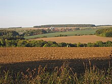
Eigenrode is located about eight kilometers north of Mühlhausen on state road 1015 above the Unstrut valley on the edge of the southern roof of the Dün . The district is located in valley and hillside locations. The soils mostly consist of weathered shell limestone and are remote from the groundwater on the slopes.
The highest point is at 465.6 meters above sea level on Eigenröder Warte, a former watchtower of the Mühlhausen Landgraben .
history
Today's Eigenrode was created in 1545 from the wasteland of Eichelroda and Ebelroda to the northeast of the current location , which in turn were first mentioned in 1246.
The area belonged to the German Empire from 1545 and was under the influence of the Free and Imperial City of Mühlhausen . In 1565 Eigeroda (Eigenrode) had a population of 37. The Eigenröder Warte secured the city territory and the traffic across the Dün to the north on the Mühlhausen Landgraben .
In 1802 Eigenrode fell together with Mühlhausen to the Kingdom of Prussia , from 1807 to 1813 to the Kingdom of Westphalia ( Canton Dachrieden ) created by Napoleon , and after the Congress of Vienna in 1816 it was assigned to the district of Mühlhausen in the Prussian province of Saxony .
The scarcity of water at high altitudes remote from the groundwater prompted the residents to build wells in the 19th century . That is why there is still the fountain festival today. It was not until 1928, after the construction of a water pipe , that the water shortage was eliminated.
After the Second World War , the village belonged to the Mühlhausen district , and from 1994 to the Unstrut-Hainich district. In September 1995 Ammern , Eigenrode, Dachrieden , Horsmar , Kaisershagen and Reiser merged to form the municipality of Unstruttal.
Agriculture
The agricultural production cooperative founded in the town during the GDR was continued as Eigenrode Agrar KG after the fall of the Wall . As part of a cooperation, the operation has been continued together with three other agricultural businesses since 2011 under the management of nordagrar GmbH, Thuringia branch . The company currently employs around 40 people, making it the largest employer in Eigenrode.
Individual evidence
- ↑ a b Eigenrode on the website of the municipality Unstruttal - district. ( Memento of the original from May 9, 2012 in the Internet Archive ) Info: The archive link was inserted automatically and has not yet been checked. Please check the original and archive link according to the instructions and then remove this notice. Retrieved January 18, 2012.
- ^ Wolfgang Kahl : First mention of Thuringian towns and villages. A manual. 5th, improved and considerably enlarged edition. Rockstuhl, Bad Langensalza 2010, ISBN 978-3-86777-202-0 , p. 66.
- ↑ Reinhard Jordan (ed.): Chronicle of the city of Mühlhausen in Thuringia. Volume 1: (- 1525). Danner, Mühlhausen 1900, p. 41 .
- ↑ Michael Köhler: Thuringian castles and fortified prehistoric and early historical living spaces. Jenzig-Verlag Köhler, Jena 2001, ISBN 3-910141-43-9 , p. 92.


