
Hemmelsdorfer See
| Hemmelsdorfer See | ||
|---|---|---|

|
||
| North shore of the Hemmelsdorfer See with Aalbek (discharge to the nearby Baltic Sea) | ||
| Geographical location | eastern Schleswig-Holstein | |
| Tributaries | Mühlenau, Aalbek , Thuraubek, u. a. | |
| Drain | Aalbek | |
| Places on the shore | Hemmelsdorf, Offendorf, Grammersdorf, Wilmsdorf, Warnsdorf | |
| Data | ||
| Coordinates | 53 ° 57 '59 " N , 10 ° 46' 58" E | |
|
||
| Depth below sea level | 0.1 m below sea level | |
| surface | 4.6 km² | |
| volume | 23,900,000 m³ | |
| Maximum depth | 39.5 m | |
| Middle deep | 5.18 m | |
| Catchment area | 36.4 km² | |
|
particularities |
a shallow and a deep basin |
|

The Hemmelsdorfer See in Schleswig-Holstein is located north of Lübeck in direct proximity to the Baltic Sea in the area of the municipalities Ratekau and Timmendorfer Strand and used to be a fjord.
Around the lake are the villages of Hemmelsdorf, Offendorf, Kreuzkamp, Wilmsdorf, Warnsdorf, Häven and Niendorf , where the outflow from the lake, the Aalbek , flows into the Lübeck Bay .
geography
Emergence
The lake was formed after the last Ice Age (the Vistula Ice Age ) when the gully carved out by glaciers was connected to the Baltic Sea and the so-called Hemmelsförde was formed. This fjord was cut off from the Baltic Sea by the masses of sand that were removed from the Baltic Sea on the Brodtener Ufer and shifted to the west by the current, thus forming today's lake.
The Hemmelsdorfer See has with a catchment area of 36.4 km² in size numerous small tributaries, u. a. the Aalbeck , which drains the Ruppersdorfer See, and the Mühlenau, which drains the Överdiek .
topography

The Hemmelsdorfer See is divided into two completely different basins in the area of the so-called Möveninsel. The larger northern basin is flat with a depth of four meters (four meters below sea level). The smaller southern basin is a large cryptodepression (consequence of an ice age glaciation). In this southern part of the Hemmelsdorfer See, the HafenCity University Hamburg carried out a study with sonar technology (side scan sonar, subbottom sonar and multibeam sonar) on August 31, 2007 in order to determine the lowest point on the mainland in Germany. The deepest point is 39.5 m, it was marked with a buoy.
ecology
Flora and fauna
The lake is largely surrounded by agricultural land. In the bank area there is a narrow forest belt with black alders and various types of willow . Reeds can be found in a strip up to 50 m wide along the entire shoreline . The narrow-leaved cattail ( Typha angutifolia ), the swimming- leaved turf , the yellow pond rose ( Nuphar lutea ) and white water lily ( Nymphaea alba ) and, very rarely, the duckweed Spirodela polyrhiza and Lemna minor and the water knotweed ( Persicaria amphibia ) can be found at various points of the bank .
Breeding birds at Hemmelsdorfer See include the mute swan, gray goose, gadfly, coot and grebes. Little gull, osprey, black tern, great egret, tufted duck and pochard occur during migration. The kingfisher and the sea eagle are regular food guests. Marsh harrier, reed warbler, great reed warbler, bluethroat, bag-titan and bearded tit are found in the reeds.

The fish population in Hemmelsdorfer See includes perch, roach, bream, ruff, pikeperch, pike, eel, carp and, to a lesser extent, rudd , moderlieschen and tench.
The northern part of the lake and the adjoining Aalbeek lowland were designated a nature reserve " Aalbeek-Niederung " on December 31, 1984 and a European bird sanctuary in 2000 over an area of 310 ha .
Water quality
According to the European Water Framework Directive (WFD), the Hemmelsdorfer See is in an unsatisfactory ecological condition. From the larger tributaries of the Mühlenau, Thuraubek and Spannau and other tributaries, the lake receives heavily to very heavily nutrient-loaded water. The visible consequences in summer are often blue-green algae and foam formation in the bank area. In terms of water quality, the Hemmelsdorfer See is one of the endangered lakes in Schleswig-Holstein.
Mixing of the body of water
In the deep, southern basin of Lake Hemmelsdorf, there is no water exchange between the oxygen-rich surface water and the deep water in summer when surface temperatures are higher. The cold, heavier deep water remains under the layer of warmer, lighter surface water.
Investigations of the oxygen content in the depths of the Hemmelsdorfer See in August 2012 showed a steep temperature drop at a surface water temperature of 19 ° C from a water depth of 7 m. 6 ° C was measured at a depth of 24 m. The oxygen content followed this temperature profile into the depth of the lake. An oxygen content of 100% was measured at the water surface; at a depth of 7 m the value was still 90%. At a depth of 8 m, the oxygen content dropped to 0%. Up to a water depth of 7 m there is an oxygen-retaining water circulation (convection), the water below is separated from this exchange.
Deep standing waters, in which the vertical water circulation does not take place over the entire depth profile, are called meromictic waters . The circulating upper layer is called the mixolimnion (mixing water) and the deep water area is called the monimolimnion . A characteristic separating layer ( metalimnion ) forms between the two layers (see graphic).
The oxygen in the deep water is more or less completely used up through degradation processes and prevents any natural development there.
The measurements of the phosphorus concentration carried out in the course of 2012 in different water depths of the Hemmelsdorfer See showed relatively lower values in the summer time from May to August in water depths of 1 m, at depths greater than 10 m significantly higher values were measured. In spring and winter, the measurements at different water depths showed practically the same phosphorus concentrations at a lower level. Outside the summer time, there is then an exchange of water with a homogeneous oxygen concentration even in greater water depths.

history
For many years it has been said that the former Viking settlement of Reric was located in the upper part of the lake . Many treatises exist, but little evidence has been found.
In the 12th and 13th centuries there was a tower-hill castle on the bank of the northern part of the lake, which is now silted up and which was bordered by a ridge . It was built on the 1.4 m high hill known as the “robber's cave”, which lies on a 6 to 7 m high tongue of the Geest, which slopes steeply there. Today the hill has a diameter of around 20 m. There, erratic blocks probably formed the foundation stones of the fortified aristocratic residence, which was probably Gosevelde Castle, which was mentioned in a document in 1255 .
During the flood of the Baltic Sea in 1872 , a large amount of salt water penetrated the lake from Lübeck Bay, which sank to the bottom of the lake due to its higher specific weight. From the subsequent observation we now know that in such a case the lake would need around 60 years for its desalination, since it was not free of salt until 1935. The natural connection between the lake and the Baltic Sea is the Aalbeek, which is regulated by a weir in the Niendorf harbor . In order to prevent salty Baltic Sea water from entering the Hemmelsdorfer See, it is only opened when the river level is above the Baltic Sea water level.
The Hemmelsdorfer See was supposed to serve Napoleon I as a naval port (see Lübeck French times ). It was extensively measured, the plans are still preserved.
In the Third Reich , the lake was supposed to serve as a submarine harbor, including a flying boat harbor. Four steel wire bollards sunk in the lake are located in the western part of the Flachsee (the northern part of the lake). Neither plan was carried out.

freetime and recreation

On the northern edge of the lake, next to the outflow to the Aalbeek, there is the 14.35 m high wooden observation tower " Hermann-Löns -Blick" ( ⊙ ). From its 12.10 m high viewing platform you have a good view of the lake.
The lake is also a popular ice sailing area , as in January 2016 when the ice was 20 cm thick.
Hemmelsdorf


In the district of Hemmelsdorf there is a small harbor for sailing and rowing boats at the fish smokehouse. The Hemmelsdorfer See is leased by the sports fishing club SAV Pliete eV in Lübeck. The fish species are: eel, pike, pikeperch, tench, carp and trout. The removal of the fish is limited.
In 2013, an approx. 0.5 km long riverside path was laid out in the Hemmelsdorf district to allow direct observation of the bank vegetation. The footbridge was built entirely from oak to fit into the landscape. The oak posts on which the footbridge is based were not peeled to maintain their durability. Other piles were prepared differently to watch their decay.
Offendorf
There is a swimming area in Offendorf.
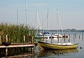
Landing at the Hemmelsdorfer See

Ice sailors on the Hemmelsdorfer See, 2011


Web links
literature
- Uwe Muuß, Marcus Petersen, Dietrich König: The inland waters of Schleswig-Holstein. 162 p., Numerous Fig., Wachholtz-Verlag Neumünster, 1973. ISBN 3-529-05302-3 .
- Otto Rönnpag: Harbor on the Hemmelsdorfer See 1898? In: Jahrbuch für Heimatkunde ( Heimatverband Eutin ), Eutin 1996, pp. 90–92.
- Rolf Köster: Young eustatic and tectonic processes in the coastal area of the southwestern Baltic Sea. Meyniana, 11 , 23-81. 1961, doi: 10.2312 / meyniana.1961.11.23 .
Individual evidence
- ↑ a b c d e f g Hemmelsdorfer See, Characteristic Data , Agriculture and Environment Portal, Ministry for Energy Transition, Agriculture, Environment and Rural Areas Schleswig-Holstein: Lakes.
- ↑ Catchment area Hemmelsdorfer See (map) , Ministry for Energy Transition, Agriculture, Environment and Rural Areas Schleswig-Holstein.
- ↑ a b c Monitoring of the quality component macrophytes / phytobenthos for WFD and FFH-RL in Schleswig-Holstein lakes 2012 , Institute for Ecological Research and Planning GmbH, Bützow, February 15, 2013.
- ↑ a b Information board for the riverside hiking trail in Hemmelsdorf.
- ↑ Lakes – Fish Species Cadastre Schleswig-Holstein Freshwater fish, ten-footed crabs and large mussels , Ministry of Agriculture, Environment and Rural Areas of the State, October 2006.
- ↑ State ordinance on the nature reserve "Aalbeek-Niederung" , State Government Schleswig-Holstein.
- ↑ 2030-303 NSG Aalbeek-Niederung (FFH area and EU bird sanctuary). Published by the Federal Agency for Nature Conservation . Retrieved November 24, 2017.
- ↑ The annual cycle of our lakes , Anglerforum-Bayern.
- ↑ Sailing on the ice: "I've been waiting for years". In: NDR Schleswig-Holstein Magazin. January 22, 2016, archived from the original on January 24, 2016 ; accessed on November 24, 2017 .
- ^ The Hemmelsdorfer See , sports fishing club SAV Pliete eV Lübeck.
- ↑ Hemmelsdorfer See, Hemmelsdorf fishing yard, harbor tour: plaque fish species
- ↑ Hemmelsdorfer See, bathing water quality in the 2014 season , Federal Environment Agency.
Elbow (northernmost point) | Rickelsbüller Koog (northernmost mainland point) | Neißeaue (easternmost point) | Haldenwanger Eck (southernmost point) | Isenbruch (westernmost point) | Zugspitze (highest point) | Neuendorf-Sachsenbande (deepest point of land) | Hemmelsdorfer See (lowest point) | Funtensee (Kaltepol) | Center of Germany (ambiguous)