
Funtensee
| Funtensee | ||
|---|---|---|
.jpg)
|
||
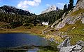
| The Funtensee in the Stone Sea | ||
| Geographical location |
Berchtesgaden National Park , Bavaria Germany |
|
| Tributaries | Chair ditch | |
| Drain | Teufelsmühle (underground) → Königssee | |
| Places on the shore | Kärlingerhaus | |
| Data | ||
| Coordinates | 47 ° 29 '37 " N , 12 ° 56' 21" E | |
|
||
| Altitude above sea level | 1601 m above sea level NHN | |
| surface | 3.4 ha | |
| length | 270 m | |
| width | 130 m | |
| volume | 86,000 m³ | |
| scope | 780 m | |
| Maximum depth | 5.5 m | |
| Middle deep | 2.5 m | |
| Catchment area | 10 km² | |
|
particularities |
Extremely low air temperatures possible |
|

The Funtensee is a karst lake in the mountain range of the stone sea in the Berchtesgaden National Park and is situated at an altitude of 1601 m above sea level. NHN . The lake has gained national fame due to its location-related cold records, which, however, are not representative of the wider area.
etymology
The origin of the sea name is disputed. The roots Fontana (“source”) or spark (“trout”) were suggested for the defining word . The spelling Fundensee can also be found in old sources .
geography
The Funtensee lies in a depression, covers about 2.5 hectares (officially 3.4 hectares are specified) and its shoreline is about 780 meters long. At the deepest point it is 5.5 meters and on average 2.5 meters deep. The water catchment area covers around 10 km².
The main tributary is the Stuhlgraben in the southeast, to which the Rennergraben flows 240 meters before the mouth on the right .
The lake has no surface or any other visible drain. On the eastern shore but on the Devil's Mill , a verstürzten Ponor , behind a rock wall, a gurgling sound from the underground drainage of over water to hear. From there, the water reaches the Königssee within eleven hours .
The Funtensee is designated by the Bavarian State Office for the Environment as a particularly valuable geotope (geotope number: 172R002).
Emergence
The depression in which the Funtensee lies was created over a long period of time through karst erosion processes and subsequent glacial deformation. From a geomorphological point of view, the shape of the terrain is a uvala . Sinking holes formed by carbonic acid weathering were carved even deeper by a glacier up to 350 m thick during the last ice age. After it melted, the glacier left ground moraines behind , which sealed off the drainage underground in the lake.
history
The use of the Funtensee area for alpine farming is documented as early as 1385. 1850 Funtenseealm was charged with 185 cattle corners , the summering was abandoned in the 1960s.
At times the border between Bavaria and Salzburg ran through the lake. This was the case before 1810 and from 1816 to 1818, in the meantime the Duchy of Salzburg belonged entirely to the Kingdom of Bavaria .
The Kärlingerhaus is located 29 meters above and 150 meters northwest of the lake , a large alpine club hut that is managed during the summer season and whose winter area is open all year round.
climate
The local climate at Funtensee has a special position. On December 24, 2001, a Meteomedia station registered a temperature of −45.9 ° C. On the same day, the lower Funtensee station of the DWD registered a temperature of −44.0 ° C. However, the DWD gives the lowest temperature for Germany -37.8 ° C (on February 12, 1929 in Hüll / Wolnzach ).
The cold extremes are explained by the topographical location of the lake, which is surrounded by mountains and lies at the bottom of a basin . In winter, the rays of the low-lying sun hardly ever reach the bottom of the mountain basin. On clear nights, the residual heat radiates. Since the cold air cannot flow out of the sink, a cold air lake is formed .
The forest ends in the surrounding mountains about 100 m above the valley basin, the lake shore and the lower valley basin are completely free of trees. However, this reversed tree line is apparently not a result of the cold air lake, but is attributed to the earlier use as an alpine farm.
photos

Funtensee from the east, in the background the Great Hundred Death
Northern shore with the Kärlingerhaus located northwest of the lake
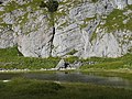
The "Teufelsmühle", the underground drain at the northeastern end of the Funtensee

Funtensee around 1900

DWD weather station on Funtensee


.jpg)
literature
- National Park Administration Berchtesgaden (Ed.): Research reports of the National Park Berchtesgaden ( ISSN 0172-0023 ):
- Research report 7: The Funtensee - natural history portrait of a subalpine lake. Berchtesgaden 1985, ISBN 3-922325-06-8 ( summary ( memento from September 20, 2015 in the Internet Archive ))
- therein (p. 7–22): Franz Jaskolla, Günther Kohlhammer, Joachim Schmolin: On the geology of the Funtensee area. (PDF; 956 kB)
- therein (p. 23–36): Klaus Fischer: The Funtensee-Uvala in the Stone Sea. (PDF; 1.5 MB)
- therein (p. 37–50): Horst Freiberg: Plant-sociological studies in the area of the alpine tree line in the Funtensee area, taking into account the anthropogenic influence. (PDF; 1.4 MB)
- therein (p. 51–65): Thomas Schauer: The vegetation of the Funtensee, Grünsee, Schwarzensee and Obersee in the Berchtesgaden National Park. (PDF; 0.9 MB)
- Research report 30:
- Research report 7: The Funtensee - natural history portrait of a subalpine lake. Berchtesgaden 1985, ISBN 3-922325-06-8 ( summary ( memento from September 20, 2015 in the Internet Archive ))
- Research report 49: Site map of the Berchtesgaden National Park. Berchtesgaden 2004, ISBN 3-922325-52-1 ( digitized version )
Web links
- Location of the Funtensee on: Bavaria Atlas of the Bavarian State Government ( information )
- Website of the national park administration about the Funtensee
- Funtenseealm . In: Agricultural and cultural heritage database . Society for Agricultural History
- Interview with the meteorologist Jörg Kachelmann about temperature extremes at Funtensee
- Current 4-day temperature forecast for the Funtensee
- Webcam Funtensee
See also
Individual evidence
- ↑ a b c d e f g h i j Water portrait Funtensee , Traunstein Water Management Office, accessed on November 28, 2013
- ↑ a b Agricultural Heritage. Society for Agricultural History, accessed October 2, 2010 .
- ^ Johann Paul Schmitt: Our Fatherland Bavaria. Historical and geographical splendid work in nine volumes of six monthly issues each . Volume 1 Upper Bavaria , Munich 1865. p. 16 ( digitized version )
- ↑ Karst hydrological markings in the Berchtesgaden National Park. (PDF; 9.6 MB) pp. 25–26 , accessed on April 21, 2016 (Section 2.4.3 Results ).
- ↑ Berchtesgaden Valley: high mountain lakes
- ↑ Bavarian State Office for the Environment, Geotope Funtensee with Teufelsmühle (accessed on October 19, 2017).
- ↑ Historical land map (first recording, dated 1808–1864) and position sheet 1: 25000 (dated 1817–1841) in the BayernAtlas , Bayerische Vermessungsverwaltung
- ^ Eduard Richter: Explanations of the historical atlas of the Austrian Alpine countries. The district court card. Volume 1 Salzburg, Upper Austria, Styria . Verlag Holzhausen, Vienna 1917
- ↑ Andreas Wagner: Weather extremes , MeteoGroup Unwetterzentrale, August 2009. Retrieved on April 24, 2015.
- ↑ Funtensee cold point and temperature curve diagrams on funtensee.de, Berchtesgaden National Park Administration. Retrieved April 24, 2015.
- ↑ Weather records - air temperature , German Weather Service. Retrieved April 24, 2015.
- ↑ The vegetation at Funtensee on funtensee.de, Berchtesgaden National Park Administration. Retrieved April 24, 2015.
Elbow (northernmost point) | Rickelsbüller Koog (northernmost mainland point) | Neißeaue (easternmost point) | Haldenwanger Eck (southernmost point) | Isenbruch (westernmost point) | Zugspitze (highest point) | Neuendorf-Sachsenbande (deepest point of land) | Hemmelsdorfer See (lowest point) | Funtensee (Kaltepol) | Center of Germany (ambiguous)