
Uvala

Uvala (the -) was originally a toponym used by people living in parts of Croatia , Bosnia and Herzegovina's, Montenegro, and Serbia . In the earth sciences “closed karst depressions” (closed karst depressions) are meant, which mostly have an elongated and differently composed shape and are larger than sinkholes . These forms are often found in the highly karstified Outer Dinarides between Slovenia and Greece . But karst depressions are found on all continents in very different landscapes, so Uvala has become an internationally used term, even to those karst depressions of the up to many kilometers long Poljen to distinguish. Definitions of uvalas that are still in use, however, are often poorly supported empirically. Because the conventional definitions were felt to be unsatisfactory, the technical term was reluctantly and rarely used. Some publications even recommend abandoning the term entirely.
More recent empirical studies (especially from 2009) have subjected the definitions that are still dominant to a thorough revision: "... uvalas are large (in km scale) karst closed depressions of irregular or elongated plan form resulting from accelerated corrosion along major tectonically broken zones." ( ... Uvalas are large - on a kilometer scale - closed karst depressions of irregular or elongated shape, which have arisen as a result of increased corrosion along mainly tectonic fracture zones). The author of the investigations advocates a full reintroduction of Uvalas as an independent karst form. The part of the definition that is still frequently encountered today, a “Uvala is created by consuming the dividing” ridges “between neighboring sinkholes” (cycle theory: 'sinkholes develop into uvalas and uvalas into poljen') is not tenable. The morphology of a Uvala is: "... by size larger than a doline and usually smaller than a polje, but differs from these two forms also in morphology and combination of genetic factors, which gives it a status of a particular karst relief form." ( larger than a sinkhole and usually smaller than a polje, but also differs from these two forms morphologically and in the combination of generic factors and makes them an independent relief form.)
History of the term "Uvala" in the early stages of karstology
Important early karstological works come from the Serbian geographer Jovan Cvijić (1865–1927), a student of Albrecht Penck ; the latter is referred to as "Nestor der Karstologie", both scientists assigned to a "Viennese School of Geography". Cvijić first looked at common phenomena in the Outer Dinarides, which were called Doline , Uvala and Polje there, and based on these for the first time described a specific geomorphology and hydrogeology of the Karst. As a result, the terms mentioned were also used as technical terms to describe corresponding phenomena in other parts of the world.
Like other first karst researchers, Cvijić (1921) believed that he could explain all karst subsidence forms (see head text of the article) as stages of a development process (= an evolution) over geological time periods: "Sinkholes develop into Uvalas and Uvalas into Poljen" (= cycle theory ). The term "Uvala" was thus defined as a stage within the theory mentioned.
However, the German morphologist Herbert Lehmann no longer regarded the Dinaric Karst as a universally generalizable model in internationally acclaimed works. In an analysis of tropical karsts, he introduced the climate as a further decisive development factor. This paradigm shift as well as now available data on karsts in other parts of the world justified doubts about the general validity of the cycle theory. This also made the usefulness of a term “uvala” defined within this theory questionable.
Current status of the definition
The majority of cycle theories today are viewed as outdated or even untenable, and a term “Uvala” in the sense of this theory is consequently discarded. The authors Ford and Williams equate Uvala's very large sinkholes in an extensive reference work in English as well as in contributions to encyclopedias . White (1988) replaces “Uvala” with “compound depression”.
Other authors replace the term "Uvala" with "sinkholes that grow together". This is contradictory, because the idea contained therein, hardly empirically founded, comes from the cycle theory, the untenability of which motivated the rejection of the term "Uvala". Typical formulations are for example: When solution dolines develop, they enlarge laterally and grow together. This creates composite closed sinks known as uvalas. Or: Large karst depressions have arisen from several neighboring sinkholes that have grown together . If only a brief definition is used, a majority of authoritative textbook and encyclopedia authors and editors now use either of these citations.
More elaborate scientific monographs , such as empirical studies, on the other hand, motivate an independent concept of the karst form “Uvala”, which is independent of cycle theory. This could be defined by special features in the distribution pattern of weathering and hydrogeology , tectonic induction, age and climatic conditions of origin. However, most of these publications analyze European objects and appear in non-English, which reduces their international resonance.
Dinaric Uvalas: Notes on Local Karst Hydrology
In the following section the term “Uvala” is used as a traditional way of designating certain reliefs within the Dinarides.
The carbonate layers of the Dinarides are 4500 to 8000 m thick, so they reach deep below sea level . There are thousands of caves, cave ruins ( unroofed caves ) and shafts, the systematic exploration of which has only been intensified in the last 20-25 years.
The Velebit is a mountain range within the Dinarides. Bakšić (2008) presented the public with the results of eight shafts in Velebit, the deepest of which, called Lukina Jama , reaches 1,431 m down to 83 m above sea level. The Velebit also shows breccias (known as Jelar breccia ) , which are open over long stretches and are very waterway. They were created by a folding movement of the ridge that lasted from the Middle Eocene to the Middle Miocene.
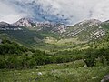
Within the Dinarides, the Velebit is probably also the landscape with the most Uvalas, including the particularly prominent Lomska Duliba in Croatia. At its southeast end there is a 536 m deep, vertical shaft called Ledena Jama , which drains part of the Uvala. The water is not drained through a single, wide passage, but through numerous crevices. This uvala shows a very deep incision (trench), which can be explained well by the Breccias typical of Velebit.
Can the independence of the 'Uvala' relief be scientifically substantiated?
New contributions to natural and formal scientific methods
Geological differences in the formation of large karst depressions that could justify a distinction between sinkholes and uvalas are rarely investigated. Further studies on radiometric age dating and interdisciplinary studies on tectonics and climatology may open a window in this regard. Important advances in natural and formal scientific methodology allow the age determination of geological objects several hundred thousand or even millions of years old, even from small samples, with high accuracy. The laboratory analysis required for this is, however, quite expensive.
For example, allochthonous sediments and fossils could be found in crevices , crevices or (best) caves in the geological environment of large karst depressions. At these sites the finds were less subject to weathering than the depression itself. As geo-archives , they allow conclusions to be drawn about the age of the depression and its earlier stages.
New age determination techniques in the Swabian Alb and in the Dinarides
With uranium-thorium dating , for example, deposits in the Karls- and Bärenhöhle (Middle Swabian Alb ) could be determined to be 440 millennia old (= 440 k ilo a nni, ka). Including paleontological methods, the cave was even in its geological environment at about 5 millions (= 5 M ega a nni, Ma) estimated.
In 2006, on the Kuppenalb , for the first time, sediments and mammal fossils from cave ruins were found to show an approx. 11 Ma old karstification phase. For this purpose, stratigraphic age determination was combined with paleontological dating of mammalian fossil remains. The latter could be biostratigraphically assigned to the taxa of the biozone MN9 , thus the time span from 11.2 to 9.5 Ma before the present.
More recent analyzes of sediment layers flooded into caves and cave ruins ( unroofed caves ) in the Slovenian Dinarides showed in some cases a sediment age of approx. 450 millennia (= 450 ka). A comparable age was determined for the Postojna Caves, also in Slovenia , by combining paleomagnetism dating with palaeontological expertise. The caves themselves were then estimated to be around 3.4 million years old (= 3.4 Ma).
A look at the very early phases: questions about genesis and evolution
A karst depression that is significantly larger than a sinkhole can be more than 2.6 Ma old; in this case their development began in the Pliocene or even Miocene , thus in a (sub) tropical climate . Some authors assume that this is how (Mediterranean) Poljen originated. However, despite the similar formation conditions, karst depressions of this age can take on different forms depending on the conditions in the given region. In the opinion of the geographer Jelena Ćalić, comparable, tectonically induced subsidence could create a polje if the affected relief in the karst water level area develops, but an uvala if it is higher.
Uvala revisited: severe corrosion along tectonic broken zones of regional folds
The geographer Ćalić transferred Čar's criticism of the previous, exclusively morphologically oriented classification of sinkholes to larger karst depressions. For this reason, she investigated such depressions in the Dinarides 43 from a structural and geological point of view . Twelve of these were topographed more precisely using a suitable method . The maps created in this way showed that in the folds on site along pronounced waterways, heavily weathered faults, primarily a relief of its own is created, the specific genesis of which identifies it as "Uvala" in a definable sense. This is how the observations listed in the section “Dinaric Uvalas: Notes on Karst Hydrology” can be understood.


Revised definition of the uvula
In 2011, Ćalić came up with a revised definition of the term "Uvala" based on the current state of research. According to this, "Uvala" denotes a closed karst depression on a kilometer scale, which, in contrast to karst-related leveling, is embedded in more or less strongly fragmented landscapes and is of irregular or elongated shape. It arises along larger faults due to particularly rapid weathering, which, unlike sinkholes, does not affect points, but lines or entire surfaces. Their bottom is always well above the karst water table; it is wavy or littered with sinkholes, rarely leveled by colluvial sediment.
Ćalić distinguishes accidents that can also be observed in Uvalas from these essential features of the Uvala . Small karst streams or ponds occur seasonally, very rarely and rather exceptionally. Four uvalas examined by Ćalić also show the effects of fluvial processes. These were effective but either only in a phase of Uvala development, as the Pleistocene glacial and periglacial processes that the shape of the Lomska Duliba influenced, or inserted as blind valleys ( blind valleys ), the essential characteristics of the uvula only further added.
Such a definition does not lead a uvula back to sinkholes like the cycle theory and thus avoids abbreviated descriptions as they are listed in the section “Current status of the definition”. Rather, the karst forms traditionally known as "uvula" can be described more impartially and completely with this very term. Some encyclopedic publications have already adopted this point of view.
Examples of (possible) Uvalas outside the Dinarides
The revised definition presented by Ćalić could also identify karst forms outside the Dinarides as Uvalas. In the following, candidates of a corresponding assignment are presented who are currently not referred to as Uvala at all or without a secured model.
- Although they reject the use of the term (see above "Current status of the definition"), Ford & Williams (2007) mention six Uvalas to indicate their occurrence in different climatic regions of different continents. In some cases they refer to publication sources. Otherwise, previous publications of the 21st century only occasionally deal with larger karst depressions, which are smaller than Poljen and can be found outside the Dinarides.
- Bayer & Groschopf (1989) describe in more detail around 70 karst depressions in the Swabian and Franconian Jura , which they refer to as “karst basins”, and of which about half are 1000–4500 m long. According to morphological criteria, they identify them as Uvalas rather than Poljen.
Pfeffer (2010) also deals with the assignment of these karst troughs. He also includes those in the (southern French) Causses and regards karst tubs as an independent form of the karst depression. Mainly because of
- own morphological findings,
- the extensive, varied fillings of the karst tubs,
- insufficient agreement with the majority of form definitions and
- the scarcity of literature on such a western or central European karst form
however, he hesitates to count her among the Poljen or the Uvalas.

(3) As part of the more detailed description of the Berchtesgaden National Park , the “ Funtensee- Uvala” in the Steinerne Meer of the Berchtesgaden Alps was examined in detail and a geological classification attempted (Fischer, 1985).
The author gives the dimensions of the Funtensee-Uvala as 2000 × 750 m. In its high alpine environment (> 1600 m) it is flanked by 1,800–2200 m high mountains. It stretches across the Funtenseegraben, a fault that presumably dates back to the Oligocene . The allochthonous limestone in the ditch is much more susceptible to weathering than that of the surrounding mountains. The exact karst water level is not known, so neither are possible fluctuations in it. Today's karst-typical hydrology was preceded by an above-ground river system that could have existed as far as the Pannonian . At the deepest point of the Uvala there remains a small, max. 5.5 m deep rest.
Fischer explains in detail why the Funtensee-Uvala is not a Polje. He leads them back (based on Cvijić) on two pre-existing sinkholes. Due to the age of the Uvala, its current shape cannot be explained solely by weathering, but is largely due to the Pleistocene glaciation. The latter also significantly increased the irregularities of the relief .
Occurrence of uvalas worldwide (some examples)
Europe (examples)
- England, Sweeting (1972)
- Ireland, Gunn (2004)
Limestone Alps
- Funtensee Berchtesgaden, Fischer (1985)
- Venetian Prealps, Sauro (2003)
Spain
- Calaforra Chordi & Berrocal Pérez (2008)
- Palomares Martin (2012),
other European countries
- Portugal, Nicod (2003)
- France, Nicod (2003)
- Romania, Ford & Williams (2007)
- Greece, Jalov & Stamenova (2005)
Dinarides
approx. 100 uvalas in 4 countries, 43 at Ćalić (2009), u. a .:
- Kanji Dol (Slovenia)
- Lomska Duliba, Veliki Lubenovac and Mirevo in the min. 25 Ma old, open-minded “Jelar brecchia”, Duboki Dol, Ravni and Crni Dol, and many more. (Croatia)
Other continents (examples)
- America
- Appalachian Mountains, Herak (1972)
- New Mexico, Ford & Williams (2007)
- Oklahoma, Ford & Williams (2007)
- Africa
- diverse, Gunn (2004)
- Marocco, Jennings (1987)
- Asia
- Iran, Bosák, et al. (1999)
- China, Gunn (2004)
- Southeast Asia (Myanmar, Thailand, Cambodia, Malaysia), Gunn (2004)
- Australia
- (Tasmania), Jennings (1987)
- New Zealand, Jennings (1987)
See also

Opened carbonate rock (without evaporites ), approx. 20% of the ice-free land area

Karstified land areas in Germany

Veliki Lubenovac, North Velebit

Ravni Dabar, Middle Velebit
Duboki Dol, South Velebit


literature
- Cvijić 1893, The Karst Phenomenon. Try a morphological monograph. Cvijic, Jovan. in: Geographische Abhandlungen A. Penck, (Ed.), Vol. V, Heft 3, Vienna
- Davies, (1899), The Geographical Cycle, Davis, William M., The Geographical Journal, Vol. 14, no. 5 (Nov., 1899), pp. 481-504
- Cvijić (1901), Morphological and Glacial Studies from Bosnia, Herzegovina and Montenegro. Part II, The Karst Poljes, Cvijić, Jovan. in: Treatises of the KK Geograph. Gesellsch., Vol. III, Book 2, Vienna 1901
- Grund (1903), The Karst Hydrography: Studies from West Bosnia. Grund, A., Geographischen Abhandlungen, Volume VII, Book 3, by A. Penck, 7, pp. 103-200.
- Grund (1914), The Geographic Cycle in the Karst. Grund, A., Geography Society, 52, 621–40. [Translated into English in Sweeting (1981).]
- Cvijić (1921), Souterraine et Evolution Morphologique du Karst, Cvijić, J., Review by Sanders, EM in: Geographical Review, Vol. 11, No. 4 (Oct., 1921), pp. 593-604
- Cvijić, (1925) Types morphologiques des terrains calcaires. Cvijić, J., Comptes Rendus, Académie des Sciences (Paris), 180, 592, 757, 1038.
- Poljak (1951), Is a karst uvala a transitional form between a doline and a karst polje ?, Polak, J., Croatian Geographical Bulletin, 13, Zagreb, 1951
- Cvijić (1960), La geographie des terrains calcaires. Academie serbe des sciences et des arts, Cvijić, J., monograph tome CCCXLI, Classe de sciences mathématique et naturelles, 26, 1-212
- Fairbridge (1968), The encyclopedia of Geomorphology, Fairbridge, RW, New York, NY, 1968
- Herak (1972), Karst, important Karst regions of the northern Hemisphere, Herak, M., Stringfield, VT, Amsterdam 1972
- UNESCO (1972), Glossary and Multilingual Equivalents of Karst Terms. UNESCO, Paris 1972.
- Sweeting (1973), Karst Landforms, selected glossary, compiled by K. Addison, Sweeting, MM, London 1973.
- Lehmann (1973/1987), karst phenomena in the northern Mediterranean region, (1973), Lehmann, Herbert, in: Fuchs, F., (ed), contributions to karst morphology, Herbert Lehmann; Reprint of still current articles, Stuttgart 1987
- Roglic (1974), Contribution to the Croatian karst terminology, Roglic, J., Krs Jugoslavije 9/1, Izdavacki zovod JAZU, Zagreb, 1974.
- Gams (1978), The polje: the problem of definition. Gams, I., Journal of Geomorphology NF 22, Stuttgart 1978
- Sweeting, (1981), Karst Geomorphology, Sweeting, MM (ed.) Benchmark Papers in Geology 59, Hutchinson-Ross. Stroudsburg, PA.
- Chorley (1984), Geomorphology, Chorley, RJ, London, 1984
- Trudgill (1985), Trudgill, S., Limestone geomorphology, London, 1985
- Fischer (1985), Das Funtensee-Uvala in the Steinernen Meer, Fischer, K., Research Report 7, Berchtesgaden National Park, 1985
- Habic (1986), Surface discussion of Dinaric Karst. Habic, P., Acta Carsologica 14/15, 1986
- Šušteršič (1986), The closed karst depression, problems of identification and cartography. Šušteršič, F., Acta Carsologica 14–15, Ljubljana 1986
- Fuchs et al. (1987), contributions to karst morphology, Herbert Lehmann, reprint of even more recent contributions, Fuchs, F., Gerstenhauer, A., Pfeffer, K.-H., (ed), Stuttgart 1987
- Jennings (1987) Karst Geomorphology, Jennings, JN, Oxford 1987
- White (1988), Geomorphology and hydrology of Karst terrains, White, WB, Oxford, 1988
- Bayer & Groschopf (1989), Karst Troughs of the Swabian Alb, Bayer, H.-J. & Groschopf, P., Blätter des Schwäbischen Albverein , 6 1989, Stuttgart
- Cocean & Petrescu (1989), Types morphogénétic d'ouvala dans le karst de Mont s Apuseni. Cocean, M., Petrescu, M., Travaux de l'institut de spéléeologie “Emile Racovitza” XVIII
- Ford & Williams (1989), Karst Geomorphology and Hydrology, Ford, DC, Williams, PW, London 1989.
- Lowe & Waltham, (1995), A Dictionary of Karst and Caves: A Brief Guide to the Terminology and Concepts of Cave and Karst Science. Lowe D. & Waltham, T., Cave Studies Series Number 6. British Cave Research Association. London, Britain. 41 pp.
- Bosák (1999), Karst and caves in salt diapers, Bosák, P., Bruthans, J., Filippi, M., Svoboda, T., Smid, J., Se Zagros Mts. (Iran)
- Kuhta & Baksic (2001), Karstification dynamics and development of the deep caves on the North Velebit Mt. - Croatia. Kuhta, M., Baksic, D., 13th International Congress of speleology, Brasil 2001
- Sauro (2001), Aspects of contact karst in the Venetian fore-alps. Sauro, U., Acta Carsologica 30/2, Ljubljana 2001
- Čar (2001), Structural basis for shaping dolines. Čar, J., Acta Carsologica 30/2, Ljubljana 2001
- EPA (2002), A Lexicon of Cave and Karst Terminology with special Reverence to Environmental Karst Hydrology, Environmental Protection Agency, Washington DC Washington DC, 2002
- Tislar et al (2002), Carbonate platform megafacies of the Jurassic and cretaceous deposits of the Karst Dinarides. Tislar, J., Vlahović, I., Sokač, B., Geologia Croatica 55/2, Zagreb 2002
- Bosák (2003), Karst processes from the beginning to the end: How can they be dated ?, Bosák, P., 2003
- Frelih (2003), Geomorphology of karst depressions: polje or uvala - a case study of Lučki dol. Frelih, M., Acta Carsologica 32/2, Ljubljana 2003
- Sauro (2003), Dolines and sinkholes: Aspects of evolution and problems of classification. Sauro, U., Acta Carsologica 32/2, Ljubljana 2003
- Nicod (2003), A little contribution to the karst terminology: Special or aberrant cases of poljes ?, Nicod, Jean, Acta Carsologica, 32,2 Ljubljana 2003
- Abel (2003), Investigations into the genesis of the Malmkarst of the Middle Swabian Alb in the Quaternary and later Tertiary, Abel, Thekla, Tübingen 2003
- Ufrecht / Abel (2003): On the Plio-Pleistocene development of the bear and Karl caves near Erpfingen (Swabian Alb) taking into account the sinter chronology, Ufrecht, W., Abel, Th. & Harlacher, Chr., Laichinger Höhlenfreund, Laichingen 2003
- Goudie (2004), Encyclopedia of Geomorphology, Goudie, AS, New York, NY, 2004
- Gunn (2004), Encyclopedia of caves and karst Science, Gunn, J., New York, NY, 2005
- Culver & White (2005), Encyclopedia of Caves, Culver, DC, White, WB, Burlington, MA 2005
- Sauro (2005), Closed depressions, Sauro, U., in: Culver & White (2005)
- Gams (2005), Tectonic impact on poljes and minor basins (case studies of Dinaric karst). Gams, I., Acta Carsologica 34/1, Ljubljana 2005
- Jalov & Stamenova (2005), Historical data for karst phenomena in the province of Macedonia, Greece, Jalov, A., Stamenova, M., Greek Cavers Meeting, Karditza 2005
- Ufrecht (2006): A sealed cave ruin stage on the Kuppenalb between Fehla and Lauchert (Zollernalbkreis, Swabian Alb), Ufrecht, W., Laichinger Höhlenfreund, Laichingen 2006
- Abel (2006): On the karstification history of the bears and Karlshöhle near Erpfingen, (Swabian Alb), in the Plio-Pleistocene with consideration of sinter chronology and paleontology, Abel, Th .; Harlacher, Chr. & Ufrecht, W., in: Jber. Mitt. Oberrhein. geol. Ver., NF 88, pp. 9-51, Stuttgart 2006
- Ford & Williams (2007), Karst Hydrogeology and Geomorphology, Ford, DC, Williams, PW, Chichester 2007.
- Zupan Hajna et al. (2008), Zupan Hajna, N., Pruner, P., Mihevc, A., Schnabel, P & Bosák, P; Cave sediments from the Postojnska-Planinska caves system (Slovenia): Evidence of multi-phase evolution in epiphreatic zone, Acta Carsologica, 37/1, Ljubljan 2008
- Calaforra Chordi & Berrocal Pérez (2008), El Karst de Andalucía, Calaforra Chordi, JM, Berrocal Pérez, JA, Sevilla 2008
- Bakšić (2008), Cross section through Mt. Velebit, with profiles of deep caves. In: Cratian Speleological Server, Zagreb 2008
- Reader (2009), Geomorphologie, Leser, H., Braunschweig 2009
- Ćalić (2009), Uvala - contribution to the study of Karst depressions (with selected examples from Dinarides and Carpatho-Balkanides). Ćalić, J., Nova Gorica 2009
- Ahnert (2009), Introduction to Geomorphology, Ahnert, F., Aachen 2009
- Pfeffer (2010), Karst, Origin - Phenomena - Use, Pfeffer, K.-H., Stuttgart 2010
- Murawski (2010), Geological Dictionary, Murawski, Hans. & Meyer, Wilhelm., Heidelberg, 2010, 12th edition
- Mihevc et al. (2010), Introduction to the Dinaric Karst, Mihevc, A., Prelovšek, M., Zupan Hajna, N. (Eds.), Postojna 2010
- Ćalić (2011), Karstic uvala revisited: Toward a redefinition of the term. Ćalić, J., Geomorphology 134, 2011
- Zupan Hanja (2012), Dinaric Karst: Geography and geology, Zupan Hajna, N., Entry in: Culver & White (2012)
- Culver & White (2012), Encyclopedia of Caves, Culver, DC, White, WB, Burlington, MA, 2nd ed. 2012
- Vlahović et al. (2012), Marine to continental depositional systems of Outer Dinarides forland in intra-montane basins, Fieldtrip Guide. Vlahović, I, and 8 other authors. 29th IAS Meeting of Sedimentology, Journal of Alpine Geology, 54, Vienna 2012.
- Palomares Martin (2012), Los paisajes de la comarca del Jiloca, Palomares Martin, M., Valencia 2012
Web links
- The Geographical Cycle, Davis, William M., 1899
- Souterraine et Evolution Morphologique du Karst, Cvijić, J., Review by Sanders, EM Geographical Review, 1921
- A Lexicon of Cave and Karst Terminology, Washington DC, 2002
- Karst processes from the beginning to the end: How can they be dated ?, P. Bosák, 2003
- The Funtensee-Uvala in the Steinernen Meer, Fischer, K., Berchtesgaden National Park Berchtesgaden, 1985
Individual evidence
- ↑ Ćalić (2011), p. 41
- ↑ so z. B. Murawski (2010)
- ↑ Ćalić (2011), p. 32
- ^ Especially Davis (1899), Grund (1914)
- ↑ For twelve years Lehmann headed an international karst commission that was founded by the International Geographic Union (IGU) at its 1952 congress in Washington, DC.
- ↑ "The Mediterranean Karst, in the narrower sense the Dinaric Karst, is not the prime example of karst development in general, but rather an exception", from: Lehmann (1973/1987), Karstphänomene im Nordmediterranen Raum , (1973), reprint 1987, ed. Fuchs et al. (1987)
- ↑ Lowe & Waltham (1995): “… This mechanism is no longer accepted and the term uvala has fallen into disuse”. "This mechanism (scil. The cycle theory) is no longer accepted, and the term 'Uvala' is therefore no longer used".
- ↑ Ford / Williams (2007): "Karst Hydrogeology and Geomorphology"
- ↑ "As solution depressions evolve, some enlarge laterally and coalesce, producing compound closed depressions known as uvalas.", Williams, Paul W., 'Karst' in: Goudie (2005) p. 591
- ^ "Large closed depression formed by the coalescence of several dolines which have enlarged towards each other." Sweeting (1973)
- ↑ For example Fairbridge (1968), Herak (1972), Chorley (1984), Jennings (1985), Trudgill (1985), Lowe & Waltham (1995), Goudie (2004), Gunn (2004), Ford & Williams (1989/2007 ), in German: Ahnert (2009), readers (2009)
- ↑ mainly on sinkholes and uvalas in Mediterranean countries , there especially in the Dinarides .
- ↑ For example Poljak (1951), Cocean & Petrescu (1989), Habič (1986), Šušteršič (1986), Frelih (2003), Nicod (2003), Sauro (2001), Čar (2001), Sauro (2003), Zupan Hajna (2012)
- ↑ This has partly to do with the fact that the financial, human and material resources of karstology for the application of complex scientific-technical methods are rather modest.
- ^ According to Vlahović et al. (2012), the breccias on the southwest slope of Velebit extend over 100 km and also appear along the entire Bakovac Trench, which is no longer topographically recognizable today.
- ↑ Vlahovic et al. (2012)
- ↑ Poljak (1951) quoted from Ćalić (2009) p. 70
- ↑ (Info J. Ćalić)
- ↑ in nuclear chemistry , which concerns the measurement of the decay time of radionuclides , as well as in the subjects of climate research , seismology , information science
- ↑ Bosák (2003) compiled 64 suitable methods, but also their limitations for karst objects and the relevant time periods.
- ↑ 'Ledena Jama' is such a cave on the eastern edge of the Uvala 'Lomska Duliba'.
- ↑ Ufrecht / Abel (2003)
- ↑ Ufrecht (2006)
- ↑ The underlying palaeontological classification ELMMZ Neogen is considered to be secure and differentiates biozones MN1 to MN17.
- ↑ See Mihevc (2010) and Zupan Hajna et al. (2008)
- ↑ cf. Reader (2009), p. 322; Ford & Williams (2007) for Australia, p. 410
- ↑ "Very similar genetic factors can lead to the development of different forms, depending on the conditions within a karst area", Jelena Ćalić (2009) p. 166f
- ^ PhD Research Associate, at the "Jovan Cvijić" Geographical Institute of the Serbian Academy of Sciences and Arts, Belgrade
- ↑ “At a certain stage of development, the same tectonic activity can lead to the formation of a polje if a subsidence reaches the piezometric level and further development takes place in the area of the karst water level ; Or, a uvala could develop if it remains in the vadose zone - with completely different surface processes. The decisive, predominant factor for both hypothetical development paths is the tectonic activity, but the other framework conditions in which evolution continues are decisive for the state ”, Jelena Ćalić (2009) p. 166f.
- ^ PhD Research Associate, at the "Jovan Cvijić" Geographical Institute of the Serbian Academy of Sciences and Arts, Belgrade
- ↑ Čar wrote in 2001: “Classification of dolines only by shape and depth to disk-like, funnel-like or well-like (Cvijić 1893) is preserved till now (Gams 2000) yet in our opinion it is useless. (...). Such morphological classification of dolines is only descriptive and does not tell anything about the 'essence' of dolines. " p. 242. (“Until now sinkholes have been classified according to their appearance and depth as bowls, funnels or shafts (from Cvijić 1893 to Gams 2000), but in our opinion this is useless. (…). Such morphological classifications of sinkholes are merely descriptive and say nothing about the 'nature of sinkholes. ")
- ↑ The karst depressions were sorted according to shape, size and height of their occurrence in the Dinarides of Slovenia, Croatia, Bosnia and Herzegovina, Montenegro and Serbia with a DEM model ( Digital Elevation Model ) and mapped with field work (Ćalić, 2011).
- ^ "Structural-geological mapping" according to J. Čar (1982, 1986, 2001) was used. The method differentiates between broken, fractured and fractured faults (as well as transitions between them) in outcrops . Broken faults contain randomly distributed fractures that break the rock into blocks from a few centimeters to several meters in size. Such faults are very holey and therefore waterway (after Ćalić (2009), p. 38f).
- ↑ Cf. Ćalić (2009, 2011): “At this stage of research, it can be concluded that uvalas are large (in km scale) karst closed depressions of irregular or elongated plan form resulting from accelerated corrosion along major tectonically broken zones. Their bottoms are undulating or pitted with dolines, seldom flattened by colluvial sediments and always situated above the karst water table. " (...) “The depressions of this kind are not present on karst leveled surfaces, but only in areas with more or less dissected relief (…)”. (Uvalas) "are forms of accelerated corrosion - not as points as dolines, but 'linear' or 'areal' (...)"
- ↑ Ćalić (2009, 2011): "(…) small seasonal sinking streams or, ponds are very rare, an exception rather than a rule."
- ↑ The same applies to other uvalas, which, like six of those investigated by Ćalić, are located at altitudes above 1100 m. Velić et al. (2011) investigated such Pleistocene processes in the Uvalas Veliki Lubenovac and Bilenski Padež , which are adjacent to those investigated by Ćalić.
- ↑ Ćalić (2011), p. 40.: "( However,) these processes were either active only during one period of uvala development (glacial processes), or represent just a modification factor (fluvial processes, related to blind valleys). Their influence was not essential for the basic existence of the uvalas. "
- ↑ The second edition of the great karstological encyclopedia by Culver & White (2012) was supplemented with the keyword 'Dinaric Karst, Geography and Geology', Zupan Hanja (2012), while U. Sauro partially revised his keyword there 'Closed Depressions'. Both authors now support the reintroduction of the term "Uvala".
- ↑ Zece Hotare plateau, Romania, p. 361f; arid Pecos Valley of New Mexico and subhumid western Oklahoma, p. 402; wet rice regions, p. 475; the 'glades' of Jamaica, p. 477; extractions of all kinds of (non-) metallic deposits “[…] that have accumulated in karst depressions such as dolines, uvalas and poljes”, p. 492
- ↑ However, the following should be mentioned: Sauro (2001, 2003), Nicod (2003), Calaforra Chordi & Berrocal Pérez (2008), Pfeffer (2010), Palomares Martín (2012)
- ↑ Bayer & Groschopf (1989), Karstwannen der Schwäbische Alb, Blätter des Schwäbischen Albverein , 6 1989, Stuttgart, p. 182.
- ↑ Pfeffer (2010) p. 210: "The karst tubs are independent shapes that show that the rock surface is temporarily deepened over a large area."
- ↑ According to Pfeffer (2010), p. 212, these fillings comprise a "range from tertiary sediments through quaternary periglacial layers to the colluvium "
- ^ The Funtensee-Uvala in the Stone Sea. Retrieved June 20, 2017 .
- ↑ Fischer (1985): The Funtensee-Uvala in the Stone Sea , p. 29: “Unknown is z. B. the depth of the border between vertical-vadosem and phreatic area and also the extent of the positional fluctuations of this transition zone ”.