
Koenigssee
| Koenigssee | ||
|---|---|---|

|
||
| View of the Königssee from the north | ||
| Geographical location | Berchtesgaden Alps , Bavaria ( Germany ) | |
| Tributaries |
West bank : Eisbach, Schreinbach (Schrainbach) East bank: Königsbach, Kesselbach, Reitlgraben, Fallaugraben, Brandgraben, Saletbach (from Obersee ) |
|
| Drain | Königsseer Ache | |
| Islands | Christlieger | |
| Places on the shore |
Schönau am Königssee St. Bartholomä (district) |
|
| Data | ||
| Coordinates | 47 ° 33 '14 " N , 12 ° 58' 40" E | |
|
||
| Altitude above sea level | 603.3 m above sea level NHN | |
| surface | 5.22 km² | |
| length | 7.195 km | |
| width | 1.225 km | |
| volume | 511.79 million m³ | |
| scope | 20 km | |
| Maximum depth | 190.0 m | |
| Middle deep | 98.1 m | |
| PH value | 7.3 to 8.5 | |
| Catchment area | 136.48 km² | |

|
||
| Depth map (1885) | ||

The Königssee is a mountain lake in the municipality of Schönau am Königssee in the Berchtesgadener Land district . Embedded between the steep mountain slopes of Watzmann and Hagengebirge , the elongated lake, together with the smaller Obersee to the southeast - around which the Steinerne Meer forms the valley end - has a fjord-like character. It is one of the cleanest lakes in Germany.
Most of the Königsee lies in the Berchtesgaden National Park . The owner is the Free State of Bavaria . With the shipping operated by Bayerische Seenschifffahrt, the lake is one of the major tourist attractions in the Berchtesgadener Land district sub- region known as the Big Five .
etymology
The name is probably not derived from "König", since the Berchtesgadener Land was never part of a kingdom until 1810 - however, until 1406, before the elevation to the prince-provosty , five of the provosts of the Berchtesgaden monastery bore the name Konrad for which at the time "Kuno" was used as a short form (whether the spelling for the lake is derived from it is also questionable: before 1454 it was "Kchunigsee" and then "Kunigsee").
The spelling Chunigesee is much older : On August 24, 1134, the Chunigesee Basilica, mentioned for the first time in the previous year, was consecrated to Saint Bartholomew , the patron saint of alpine farmers - the first previous church building on the site of today's pilgrimage church of St. Bartholomä . In response to this, the lake was also temporarily called Bartholomäsee .
Since around the end of the 19th century, the lake has been consistently spelled with two "s" (the first s is a fugue-s ) as "Königssee".
geography
Emergence
Today's Königssee lies in a tectonic rift valley that was probably formed as early as the end of the Jura . During the Ice Ages , the Königsseegletscher basin was excavated several hundred meters deep, only the resistant Dachstein limestone in the area of today's Königssee was abraded, but not removed in large volumes. During its peak, the ice must have covered the valley floor about 900 meters, as shown by the glacial lateral moraines in the area of the Kühroint plateau. After the glacier retreated , the lake remained and the gravel began. Since the rocks surrounding the lake basin proved to be significantly more resistant to erosion than, for example, in the Wimbach Valley on the other side of the Watzmann, the lake was preserved with a depth of up to 190 meters.
Location and landscape
The lake flows through the Königsseer Ache , Berchtesgadener Ache and Königsseeache to the Salzach . In the west, the deeply cut ice valley opens, behind which the highest wall in the Eastern Alps, the Watzmann east face , builds up. From the lake level to the southern and central peaks there is a difference in altitude of over 2100 meters, the pure wall height is almost 1800 meters. At the foot of the wall there is the so-called ice chapel , a huge remnant of avalanche snow from which the Eisbach (ice ditch) regularly melts an ice grotto that is in danger of collapsing. Over the millennia, this stream has formed a peninsula in the Königssee from the rubble it carried with it, the approximately 85-hectare Hirschau , on which the old pilgrimage church of St. Bartholomä and a hunting lodge with an inn are located.
At the northern end of the lake lies east of runoff into the Königsseer Ache of the district ( Gnotschaft ) Konigssee the same district Koenigssee the town of Berchtesgaden . To the west of the Königsseer Ache lies the Schönau district , with the Unterschönau community on the northwestern shore of the lake.
The Königssee is separated from the outflowing Königsseer Ache in the far north by the Seeklause . This weir was originally built around 1560 for the Holztrift as a wooden structure. After a flood in 1787 destroyed the Seeklause, it was replaced by a structure made of stone blocks. After severe damage, it was rebuilt between 1938 and 1940 in the shape that still exists today with a wooden bridge for pedestrians and a shingle-covered hipped roof . After the Holztrift ended in 1970, it only serves to regulate runoff and the sea in order to keep the water at a constant height for shipping. The building has its own house number , An der Seeklause 25 , and is a listed building under file no. D-1-72-132-105 of the Bavarian State Office for Monument Preservation .
The regulation of the runoff from the Königssee into the Königsseer Ache is the subject of a citizens' initiative that calls for measures to reduce the risk of flooding along the Königsseer Ache.
Also in the northern part of the lake is Christlieger, the only island on the Königsee. At the southern end of the lake, at the head of the valley, lies the Saletalm (also spelled Sallet ), where the Saletbach flows from the Obersee. The two lakes were probably not separated by a prehistoric landslide (probably 1172 AD). Rather, two terminal moraine walls of the Königsseegletscher between the two bodies of water suggest that Obersee and Königssee never formed a unit.
Opposite the St. Bartholomä peninsula is the Reitl ⊙ , a game feeder and former hunting stand of Emperor Friedrich III.
The lake can be seen from the higher peaks such as the Jenner or the Mooslahnerkopf . The fire palven on the Gotzenalm offers a special view of St. Bartholomä with the Watzmann east wall towering in the background . Other well-known viewpoints are the Halsköpfl in the south, the Archenkanzel under the Kleiner Watzmann, and the viewpoint on the Rabenwand . The view of the Königsee from Malerwinkel has shaped the classic image of the lake in a special way. From here you can see the lake, which is dominated in the background by the striking Felshorn of the Schönfeldspitze ( 2653 m ) in the Steinerne Meer , together with the little church of St. Bartholomä on the Eisbach peninsula in its entire length.
The Königssee and St. Bartholomä landed in 2015 in 12th place of the TOP 100 sights in Germany .
Development and use
shipping


Passenger shipping on the Königssee began as early as the 18th century, and the locals used rowing boats to carry goods, animals and travelers to various parts of the lake. Steam ships and petroleum-powered ships were only used on a trial basis, but were not used permanently because of their environmental problems . In the 21st century, the Königssee is used by Bayerische Seenschifffahrt with 18 large electric motor boats, plus a smaller electric motor boat, which is the masterpiece of a boat builder. The first electric motor boat entered service in July 1909. Until 1998 the boat hulls were made of wood. The last three new buildings (1998 EMB Bischofswiesen, 2003 EMB Berchtesgaden and 2017 EMB Marktschellenberg) were placed on a steel hull for the first time.
Moorings:
- Starting point in the district of Königssee (Seelände) ⊙
- St. Bartholomä ⊙
- Saletalm ⊙
- Boiler , demand stop ⊙
About halfway to St. Bartholomä, the boat driver demonstrates the echo on the echo wall with a flugelhorn or a trumpet , which can be heard once or rarely twice. In the past, a firecracker was fired from the ship and an echo of up to seven times was generated; however, carrying black powder is now prohibited for safety reasons.
The use of private boats and diving are not permitted. However, rowing boats can be rented from Schifffahrt Königssee.
Hiking trails and huts


The Königssee is cut deep into the surrounding mountains. The walls surrounding it often drop steeply towards the lake. It is therefore not possible to go around the lake near the shore. The chapel of St. Bartholomä on the alluvial cone of the Eisbach, already visible from the Malerwinkel near the village of Königssee, is on the footpath
- from Ramsau, Schönau or the village of Königssee via the privately managed Kührointalm ( 1420 m , overnight accommodation) and the partly exposed and not harmless Rinnkendlsteig or
- from Ramsau through the Wimbachtal via the Wimbachgrieshütte , the Trischübel pass ( 1774 m ) and the exposed Sigeret plate . For both tours you should estimate at least six hours of walking.
From St. Bartholomä a trail leads in around an hour into the rear Eisbach valley to the ice chapel at the foot of the Watzmann east face. This lowest snowfield in the Alps, which exists all year round, extends down to a height of 930 meters. At the exit of the Eisbach, the barrel-shaped vault that gives it its name forms over many years, which should not be entered due to the risk of icefall. Mountaineers who want to climb the Watzmann east face can use the east face camp near St. Bartholomä for a one-time overnight stay. All other visitors to St. Bartholomä have to take the last boat of the Königsseeschifffahrt to Schönau / Königssee at the latest.
From the rear Königssee boat landing in Salet, a path leads into the Oberseekessel to the Fischunkelalm and the Röthbach Falls . Via the Röthsteig you can climb from Salet in around three hours to the Wasseralm , a small alpine club hut at 1423 m , and further into the Steinerne Meer. However, the most frequently chosen ascent from the shores of Lake King leads into the heart of this ausgedehntesten massif of the Berchtesgaden Alps of St. Bartholomew on the serpentines Saugasse in just over three hours to the 1630 m high altitude Kärlingerhaus on Funtensee. The large refuge, also known as the Funtenseehaus , can alternatively be reached from Salet via the steep Sagerecksteig and the idyllic Grünsee in around four hours.
From the Kessel stop and from Salet ( Kaunersteig ) two climbs lead up into the Hagen Mountains . As an alpine base, the Gotzenalm ( 1685 m ) offers hikers and mountaineers accommodation here. From here you can hike over promising high-altitude trails either to the middle station of the Jennerbahn (downhill ride to the village of Königssee) or to the Wasseralm in the Röth. In contrast to the otherwise very secluded areas of the Hagengebirge, the area between Jenner and Gotzentauern is very popular with hikers in the summer months.
As ski tours offer Small and Large Reibn the tour-goers demanding fields of activity in which the Koenigssee is avoided on high-altitude routes.
Use in winter

Because of its size, the lake only freezes over completely in very cold winters, on average about once a decade. This was most recently the case in January and February of 2006. The ice cover of the Königsee, which was up to 40 cm thick at the time, was officially open to inspection for a total of 29 days. Before that, the ice surface of the Königssee was cleared in 1985, 1987 and 1997. The prerequisites for such a natural spectacle are very cold weather and calm. Shipping will then cease. When a sufficiently thick ice cover has formed (at least 15 cm), a hiking trail over the ice to St. Bartholomä is marked and opened for pedestrians, cyclists and cross-country skiers. The marked path should be adhered to, as the western side of the lake always has a thinner ice cover than the eastern side.
On the northern bank is the Königssee artificial ice rink for bobsleigh , luge and skeleton sports, where numerous competitions such as world championships, world cup races and European championships were held.
Almer pilgrimage
Every year on the Saturday after Bartholomew's Day (August 24th), St. Bartholomä is the destination of the Almer pilgrimage , during which pilgrims from the Pinzgau , coming from Maria Alm , descend via Ramseider Scharte ( Riemannhaus ) and Funtensee ( Kärlingerhaus ) through the Steinerne Meer make a pilgrimage to the Königssee. The pilgrimage is the oldest mountain pilgrimage in Europe and dates back to 1635. The reason for the start of the pilgrimage was the plague that was raging in the Salzburg area at the time . On August 23, 1688, 70 pilgrims drowned after their raft capsized near the drop-off point in Reitl on the opposite bank of St. Bartholomä, as was reconstructed on the basis of a protocol with statements from survivors. The cause was negligence. A red memorial cross on the Falkensteiner Wall, not far from the Königssee pier, reminds of the accident that actually occurred much further back on the lake.
Aquatic ecology


Since there is no agriculture in the catchment area of the lake (136.48 km²) apart from some alpine farming, all settlements on the lake have been connected to the sewer system since the 1980s and shipping is electric, the lake is extremely low in nutrients ( oligotrophic ), very clean and has drinking water quality.
Another source gives the area of the catchment area at 131.36 km² and divides it into five tributaries:
- Schrainbach (50.4 km²)
- Obersee (Saletbach) (39.32 km²)
- Kesselbach (including the smaller Reitlgraben, Fallaugraben and Brandgraben according to the map on p. 10 and p. 21) (15.5 km²)
- Eisgraben (14.7 km²)
- Königsbach (11.23 km²), which pours over a waterfall on the rock face into the lake.
The lake is rich in trout and char and is fished by a professional fisherman. In St. Bartholomä two particularly large specimens are exhibited in showcases, of which it is said: “The lake trout weighed 55 ℔ , caught on October 21, 1976 in the ice corner by fisherman Rud. Amort "() (55 ℔ corresponds to 27.5 kg ). This statement can be found on the display board of a char: "This char weighed 8 ℔, was caught by Joseph Düxner in July 1723" (in 1723 8 ℔ corresponded to around 4.5 kg).
legend
A legend is about Swanhilde , a swan maiden at Königssee.
particularities
A VW Beetle has been lying on the bottom of the Königsee since January 1964 . In 1998 Hans Fricke sailed the lake with his research submersible Jago and found the wreck of the Volkswagen from the 1950s at a depth of around 130 meters. The beetle had sunk in the water after a man drove illegally across the frozen lake and got into a non-frozen area near the Falkensteiner wall. Although the lake was open to motor vehicles several times at the beginning of the 20th century, the crossing was not permitted on that day. When it was discovered, the vehicle was still in good condition due to the lack of oxygen at great depths. The oldtimer remains at the bottom of the Königsee for the time being, as the location of the Königsee in the Berchtesgaden National Park prohibits a rescue operation.
The intercity train pair 2082/2083, which runs daily between Hamburg and Berchtesgaden, is called Königssee .
In their title Die Sennerin vom Königsee , the lake - with the missing joint-s - was thematized by the band Kiz .
The record for circling the lake on foot on the route Gnotschaft Königssee – Königsbachalm – Hochgschirr – Fischunkel – Salet – Schrainbachtal – St. Bartholomä – Kührointhütte – Eisarena is held by mountain runner Stephan Tassani-Prell with 4:54 hours, set up in July 2009.
administration
The management of the lake, which is owned by the Free State of Bavaria, lies with the Bavarian Administration of State Palaces, Gardens and Lakes .
Picture gallery
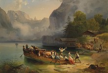
Friedrich Gauermann : Königssee at the landing place, around 1840

Photo taken in July 1903

The Königssee seen from St. Bartholomä out of the valley

Königssee pier as seen from the Kehlsteinhaus . At the edge of the forest the artificial ice rink Königssee

Königssee with Watzmann east face
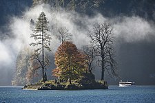
Christlieger Island in the autumn fog


See also
literature
- Joachim Burghardt: Forgotten paths around the Königssee. Bruckmann, Munich 2009, ISBN 978-3-7654-5018-1 . There is also a short bibliography on the Königssee and the surrounding mountains (PDF; 276 kB).
- Erica Schwarz: The Königssee. Monograph of a mountain lake . Vonderthann'sche Buch-Offset-Druckerei und Verlag, Berchtesgaden 1998, ISBN 3-925647-23-6 .
- O. Siebeck: The Königssee. A limnological project study . Research report 5 of the Berchtesgaden National Park. 2nd Edition. 1985, ISBN 3-922325-04-1 ( PDF ).
- August Sieghardt: Königsseer Büchl. A companion through culture and landscape . Munich 1949.
- Mark Vetter: Landscape ecological analyzes in the Königssee catchment area . Dissertation, submitted 2003 in Munich, ISBN 3-925308-59-8 ( ub.uni-muenchen.de (PDF))
- Wilhelm Goldbaum : Autumn days at the Königssee . In: The Gazebo . Issue 46, 1885, pp. 770-771 ( full text [ Wikisource ]).
Cards:
- Berchtesgaden National Park Topographic map 1: 25,000, Bavarian State Surveying Office, Munich
- AV card sheet No. 10 Steinernes Meer / Hochkönig, Hagengebirge 1: 25,000 (also digital / DVD).
- Freytag & Berndt WK 102 Untersberg · Eisriesenwelt · Königssee 1: 50,000.
- Freytag & Berndt Sheet 10 Berchtesgadener Land / Salzburg Limestone Alps 1: 100,000.
Web links
- The Königssee , website of the Berchtesgadener Land Tourismus GmbH (see also section District- wide marketing in the article Landkreis Berchtesgadener Land ), online at berchtesgaden.de
- Schifffahrt Königssee , website of Bayerische Seenschifffahrt GmbH , online at seenschifffahrt.de
Individual evidence
- ↑ a b c d e f g h i Part 11: Bavaria. (PDF; 1.7 MB) Documentation of the condition and development of the most important lakes in Germany
- ↑ oete.de ( Memento of April 27, 2014 in the Internet Archive ) PDF documentation of ecological tourism in Europe pp. 61 f., 64 f., 70 f.
- ↑ Where does the name Königssee come from? ( Memento from April 2, 2018 in the Internet Archive ); see penultimate article link within the link list Frequently asked questions about Königssee (without further indication of source), online at seenschifffahrt.de .
- ↑ A. Helm : Berchtesgaden in the course of time , p. 289 f.
- ↑ See position sheet of the Bavarian first recording from the time between 1817 and 1841 in the BayernAtlas . Retrieved January 18, 2017.
- ^ A b Limnology working group of the Zoological Institute of the University of Munich: Der Königssee. A limnological project study. (PDF; 91.7 MB) Berchtesgaden National Park Administration, 1982, accessed on April 16, 2010 .
- ↑ EuRegio: Seeklause - Schönau a. Koenigssee
- ↑ Top 100 sights in Germany. Rank 12: Königssee with St. Bartholomä Church and Malerwinkel circular hiking trail. German National Tourist Board V., accessed on August 1, 2015 .
- ↑ Electric mobility: whisper quiet across the Königssee
- ↑ In October 2007, in response to great media coverage, this service was temporarily discontinued by employees of Königssee-Schifffahrt in protest. The announced 2008 new operating agreement provided inter alia a system for the acceptance of a tip, which the hitherto practiced, the passenger coercive targeted practice. - Heiner Effern: A devastating echo . In: sueddeutsche.de , October 5, 2007, accessed on July 25, 2010.
- ↑ When the ice comes, the snow has to go. Retrieved January 21, 2019 .
- ^ The ferry accident from Königsee: br.de
- ^ O. Siebeck: National Park Berchtesgaden: The Königssee. A limnological project study. (PDF) Limnology working group of the Zoological Institute of the University of Munich; Research reports , 5/1982, ISBN 3-922325-04-1 , p. 126
- ↑ https://www.flickr.com/photos/wwr/28661052098
- ^ Irmgard Prestel: Alpine sagas . Retold by I. Prestel , Deutsche Jugendbücherei No. 349. Publisher: Berlin, Hillgers Deutsche Bücherei, 1950.
- ↑ Gertrud Scherf: Mermaids, Wichtlein, Wilde Frauen - A cultural history of the natural spirits in Bavaria. Allitera Verlag, Munich 2017, ISBN 978-3-86906-986-9 .
- ↑ The treasure in Königssee . koenigssee.berchtesgadeninfo.de
- ↑ About the VW Beetle that sank in 1964. taunuskaefer.de
- ↑ Direct connections to Berchtesgadener Land and Chiemgau , proof of connection Hamburg – Berchtesgaden of the intercity train pair 2082/2083 Königssee , online at bahn.de
- ↑ Denis Wischniewski: Speed record running . In: TRAIL magazine. No. 10, December 2009, p. 82.
- ↑ Königssee on the Bay's website. Lock management