Grünsee (Berchtesgadener Land)
| Grünsee | ||
|---|---|---|

|
||
| Grünsee seen from the north | ||
| Geographical location | Berchtesgaden Alps | |
| Tributaries | Brook from the Grünsee Alm | |
| Drain | to the Königssee (underground) | |
| Places on the shore | Grünsee-Alm (av.) | |
| Location close to the shore | Schönau a.Königssee | |
| Data | ||
| Coordinates | 47 ° 30 '7 " N , 12 ° 57' 11" E | |
|
|
||
| Altitude above sea level | 1474 m above sea level NHN | |
| surface | 3.9 ha | |
| length | 320 m | |
| width | 120 m | |
| volume | 204,000 m³ | |
| Maximum depth | 9.2 m | |
| Middle deep | 5.2 m | |
| Catchment area | 2 km² | |
|
particularities |
||
The nearly four hectare large Grünsee in the Berchtesgaden Alps is located in the Bavarian town of Berchtesgaden , district forestry St. Bartholomew , state forest district XXIV forecast Reck, Division 3 Grünsee near the Salzburg 's border and Berchtesgaden National Park .
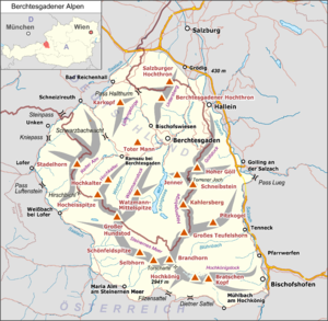
It is 2.1 km in the southwest above the Königssees ( air line ), and 670 m in the northwest below the dilapidated Grünsee-Alm ( 1598.7 m high, 600 meters southeast of the lake) at 1474 m . The lake lies together with the Schwarzensee 1050 meters northeast in the Halsboden (also Halsgrube ), a plateau between the Simetsberg and the foothills of the Funtenseetauern in the Steinerne Meer . It is accessible via the Sagerecksteig .
It is a karst lake , as are the neighboring lakes Funtensee (1150 m southwest) and Schwarzensee. It drains underground to the Königssee, whereby the water needs about 6 hours on the fastest way.
See also
Individual evidence
- ↑ a b c d e f g Water portrait Grünsee , Traunstein Water Management Office
- ↑ Land map and land map
- ↑ Berchtesgaden Valley: high mountain lakes
- ↑ Karst hydrological markings in the Berchtesgaden National Park. (PDF; 9.6 MB) pp. 25–26 , accessed on April 22, 2017 (Section 2.4.3 Results ).
