Obersee (Koenigssee)
| Obersee | ||
|---|---|---|

|
||
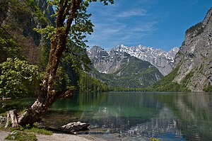
| The Obersee seen from the south bank, out of the valley towards the northeast the Watzmann , in front of it the Hachelköpfe and the Burgstall above St. Bartolomä, Sagereckwand on the left, Kaunerwand on the right | ||
| Geographical location | 600 m southeast of the Königsee |
|
| Tributaries | Röthbach , Landtalgraben, Seilstattgraben → Fischunkel (groundwater flow) | |
| Drain | Saletbach → Königssee | |
| Places on the shore | Fischunkelalm | |
| Location close to the shore | Schoenau upon Kings sea | |
| Data | ||
| Coordinates | 47 ° 30 '58 " N , 12 ° 59' 18" E | |
|
|
||
| Altitude above sea level | 613.1 m above sea level NN | |
| surface | 57 ha | |
| length | 1.32 km | |
| width | 420 m | |
| volume | 16,855,000 m³ | |
| scope | 3.5 km | |
| Maximum depth | 51 m | |
| Middle deep | 29.60 m | |
|
particularities |
||
The Obersee is a natural mountain lake in the Berchtesgaden Alps in Upper Bavaria .
description
The catchment area of the lake extends over 38 km², with an average depth of 29.60 m and a maximum of 51 m, it has a water volume of 16,855,000 m³. With a length of 1.32 km, a width of 0.42 km and a circumference of 3.5 km, it covers an area of water of 57 hectares . Its water level is 613.1 m above sea level. NN .
It is separated from Königssee , a little to the north, by a moraine wall , the extent of which is estimated to be 700 m long, 800 m wide and 320 m high. The rubble from a landslide that fell in 1172 is still visible today in the form of mighty blocks in the alluvial forest of the valley floor and the Aualmen of the Saletalm .
On the south bank lies at an altitude of 620 m above sea level. NN the 500-year-old Fischunkelalm , which is managed by two dairymen from mid-May to mid-October .
On the long sides of the islandless lake rise 1000 m high rock walls, while on the southern bank the terrain gently rises. From the 470 m high Röthwand rising behind it, the Röthbachfall falls onto the Almboden, and from the chest wall to the north, the Landtalgraben. The brooks unite and seep into the Fischunkel , the rearmost part of the valley, and flow underground to the Obersee.
The Obersee feeds the Königssee, which is called Saletbach , via an approximately 600 m long torrent . Halfway to the Königssee, the brook widens south to the small Mittersee . This is around 110 m long and 60 m wide, with a size of only 0.44 ha. The water level is at a height of 608 m above sea level. NN .
The Obersee has not been fished since the creation of the Berchtesgaden National Park on August 1, 1978. Today, numerous species of fish can be found in the Obersee, including above all the arctic char and the lake trout .
Obersee around 1900, in the basin above the Röthwand is the Wasseralm , on the left Hochsäul (2073 m)
In the valley, in the background the Röthbachfall , behind the devil's horns
Impressions from the Obersee
See also
- Königssee - hiking trails , where the network of trails in the national park area is shown in detail.
- List of lakes in Bavaria
Web links
- Water management office Traunstein: data on the Obersee
- Fischunkelalm
- Rockslide between Koenigssee and Obersee in the Bavarian Environmental Object Catalog
Individual evidence
- ↑ The emerald green Königssee in Berchtesgaden: History of the origins of the Königssee , berchtesgadeninfo.de
- ↑ Limnology working group of the Zoological Institute of the University of Munich: Der Königssee. A limnological project study. (PDF) Berchtesgaden National Park Administration, 1982, accessed on November 21, 2014 .
- ↑ The Röthbachfall is at approx. 380 m the highest waterfall in Germany, see WikiVoyage: Königssee: Obersee


