
Saletalm
| Saletalm | ||
|---|---|---|
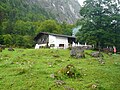
 The Saletalm with boat landing stage, in front the southern end of the Königssees, in the back Obersee |
||
| location | Schönau am Königssee , Upper Bavaria | |
| Mountains | Hagen Mountains / Steinernes Meer | |
| Geographical location | 47 ° 31 '21 " N , 12 ° 58' 29" E | |
|
||
| Form of ownership | Entitlement alm | |
| height | 605 m above sea level NN | |
| surface | Alpine pasture 51 ha of forest pasture 130 ha |
|
| Waters | directly on the lake shore, source at the Herzoghaus | |
| climate | warm | |
| flora | Grasses, dock, milkweed and attich | |
| fauna | Red deer | |
| use | bumped and entertained | |
| particularities | the Alm is lower than the Talhof | |

The Saletalm (also spelled Sallet ) is an alpine pasture directly at the southern end of the Königsee . The Salet landing stage of the Königsseeschifffahrt is located on the alpine pasture , as well as the Salet-Alm restaurant and an alpine hut with refreshment stops, just a few minutes' walk away .
Salet was mentioned in a document as early as 1516, the name derives from the Latin illud salectum ( willow thicket ).
The history of the tourist development of the Saletalm began on June 3, 1912, when the married couple Michael Hofreiter and Rosa John received a concession from Prince Regent Luitpold of Bavaria to build a kiosk with 16 m² of land for their wedding . This hut was steadily expanded into today's restaurant, built in 1966, which can seat more than 300 people with outside seating. However, it has no overnight accommodation.
hikes
- Saletalm - Obersee - Fischunkelalm
- Saletalm - Obersee - Fischunkelalm - Röthbachfall
- Saletalm - Sagerecksteig - Grünsee - Kärlingerhaus
- Saletalm - Kaunersteig - Regenalm - Gotzenalm
- Saletalm - Röthbachfall - Röthsteig - Wasseralm or Gotzenalm
See also: Section hiking trails and huts in the article about the Königssee with a detailed description of the network of trails in the national park area.
Picture gallery
Salet-Alm restaurant
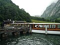
Sea-side view of the boat dock

Landside view of the boat dock

.jpg)
.jpg)
Web links
- Saletalm . In: Agricultural and cultural heritage database . Society for Agricultural History , accessed October 22, 2012
Individual evidence
- ↑ Saletalm - Flora on agrarkulturerbe.de, accessed on January 23, 2020
- ↑ Saletalm - Fauna on agrarkulturerbe.de, accessed on January 23, 2020
- ↑ Berchtesgaden National Park , topographic map 1: 25,000, Bavarian State Surveying Office, Munich
- ↑ Saletalm - History , Agricultural and Cultural Heritage Database , accessed on November 9, 2015
- ^ Website of the Saletalm restaurant - history