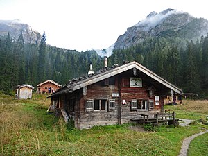
Wasseralm
| Wasseralm DAV hut category I. |
||
|---|---|---|
|
Wasseralm in the Röth, 2018 |
||
| location | between the Hagen Mountains and the Stone Sea ; Bavaria , Germany | |
| Mountain range | Berchtesgaden Alps | |
| Geographical location: | 47 ° 29 '41 " N , 13 ° 0' 23" E | |
| Altitude | 1423 m above sea level NN | |
|
|
||
| owner | Berchtesgaden section of the DAV | |
| Construction type | Hut; Lumber | |
| Usual opening times | Late May to early October | |
| accommodation | 0 beds, 60 camps , 0 emergency camps | |
| Winter room | 20 bearings | |
| Web link | Website at the section | |
| Hut directory | ÖAV DAV | |

The Wasseralm is an abandoned alpine hut and a small alpine club hut belonging to the German Alpine Club at an altitude of 1,423 m in the remote Röth basin between the Hagen Mountains and the Steinerne Meer high above the Obersee . The former self-catering hut has been simply managed in the summer months since 2005 and supplied by helicopter. Because a maximum of 60 people can stay, groups are advised not to go to the Wasseralm on weekends. The Wasseralm is an important base for mountaineers who go on multi-day tours. In winter, the hut is located on the Große Reibn , the long ski tour from Jenner via Hagengebirge and Steinernes Meer to the Wimbachtal .
history
The alpine huts were demolished in World War II . A kaser was rebuilt in 1950 from the remains of the Göring hunting lodge . In 1956, Alm was the last time you bumped .
From 1951 overnight accommodation was offered by the national park administration , since 1969 the Wasseralm has been leased by the Berchtesgaden section of the German Alpine Club and is now their property. Another bed hut was built in 2014/15. The current tenant is Horst Schellmoser.
Accesses
- From the Saletalm ( 610 m , jetty) via Obersee, Fischunkel and Röthsteig, difficulty level I according to UIAA , continuously marked and partially secured, walking time: 3 hours
Transitions
- Gotzenalm ( 1685 m ) via Landtal and Regenalm , medium, walking time: 4 hours
- Stahlhaus ( 1736 m ) or Schneibsteinhaus ( 1670 m ) via Landtal, Hochgschirr, Seeleinsee and Schneibstein , medium, walking time: 7 hours
- Kärlingerhaus ( 1635 m ) via Halsköpfl , Schwarzensee and Grünsee , medium, walking time: 4 hours
- Kärlingerhaus ( 1635 m ) via the Blaue Lache , Lange Gasse, Niederbrunnsulzenscharte and Totes Weibl, medium, walking time: 6 hours
- Eckberthütte via Blaue Lacke, Mauerscharte ( 2180 m ), Häuslalm, not marked, climbing points of difficulty level I, not secured, walking time: 6 hours
Mountaineering
- Great Devil's Horn ( 2363 m ), marked, difficulty level I according to UIAA , walking time: 3½ hours
- Kleines Teufelshorn ( 2283 m ), markings have faded, difficulty level I according to UIAA , walking time: 3 hours
- Alpriedlhorn ( 2351 m ) over the Blaue Lache and Mauerscharte, partly marked, not secured, walking time: 3½ hours
- Funtenseetauern ( 2579 m ) via the Blaue Lache, Lange Gasse and southern flank, partially marked, walking time: 5 hours
- Halsköpfl ( 1719 m ) via the Höhenweg to the Kärlingerhaus, easy, walking time: 1½ hours
- Kahlersberg ( 2350 m ), difficulty level I according to UIAA, marked and secured, walking time: 4½ hours
literature
- Section Berchtesgaden in the German Alpine Association (Ed.): 125 years of Section Berchtesgaden in the German Alpine Association 1875–2000. 2000, pp. 113–116 (PDF, 17 MB)
Web links
- Wasseralm , DAV hut search
- Section Berchtesgaden in the DAV
- Wasseralm . In: Agricultural and cultural heritage database . Society for Agricultural History
- Wasseralm in the historical Alpine archive of the Alpine associations in Germany, Austria and South Tyrol (temporarily offline)
Individual evidence
- ^ History of the Wasseralm , Agricultural and Cultural Heritage Database. Retrieved August 23, 2016.
- ↑ Wasseralm in the Röth . In: alpenverein.at . Retrieved August 23, 2016.

