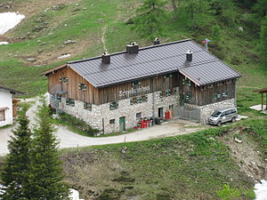
Schneibsteinhaus
| Schneibsteinhaus | ||
|---|---|---|
| location | on the Schneibstein in the Hagen Mountains ; Bavaria , Germany ; Valley location: Schönau am Königssee | |
| Mountain range | Berchtesgaden Alps | |
| Geographical location: | 47 ° 34 '19 " N , 13 ° 2' 23" E | |
| Altitude | 1668 m above sea level NN | |
|
|
||
| owner | Private | |
| Construction type | hut | |
| Usual opening times | Open all year round, closed from the beginning of November to Christmas | |
| accommodation | 18 beds, 58 camps | |
| Web link | Site of the hut | |
The Schneibsteinhaus is a refuge at 1668 m above sea level. NN am Schneibstein in the Hagen Mountains , part of the Bavarian Berchtesgaden Alps . Due to its easy accessibility from Jenner, the refuge is a very popular destination for hikers and day visitors, but also an excellent starting point for mountaineers who can go on longer tours in the Hagengebirge or Göllstock from here. The Schneibsteinhaus is open from May 1st to October 31st. In winter only on request (groups of 30 people or more).
Accesses
- From Golling via Gasthaus Bärenhütte (506 m) in the Bluntautal (parking lot) on path 451 via Jochalmen and Carl-von-Stahl-Haus , walking time 4 hours
- From Königssee (610 m, Jennerbahn car park ) on path 497 via Hochbahn and Königsbachalm , walking time: 3.5 hours
- From Hinterbrand (1,130 m, chargeable parking lot) via the Mitterkaseralm, walking time: 2 hours
- With the Jennerbahn to the mountain station (1,802 m), from there via the Höhenweg, walking time: 45 minutes
Transitions
- Carl-von-Stahl-Haus (1,736 m), closest neighboring hut, walking time: 15 minutes
- Alpeltalhütte (1,100 m) via Mitterkaseralm, easy, walking time: 2 hours
- Purtschellerhaus (1,692 m) via Hohes Brett, Hoher Göll and Salzburger Steig, difficulty level I-II according to UIAA , partially secured, walking time: 6 hours
- Kehlsteinhaus (1,820 m) over Hohes Brett, Hoher Göll and Mannlgrat, difficulty level I-II according to UIAA, partially secured, walking time: 7 hours
- Gotzenalm (1,685 m) via Priesbergalm and Hirschenlauf, medium, walking time: 4 hours
- Gotzenalm (1,685 m) via Schneibstein, Seeleinsee, Hochgschirr and Regenalm , medium, walking time: 7 hours
- Wasseralm (1,423 m) via Schneibstein, Seeleinsee, Hochgschirr and Landtal, medium, walking time: 7 hours
Mountaineering
- High board (2,340 m) over Carl-von-Stahl-Haus, Pfaffekegel and Jägerkreuz, medium, walking time: 2 hours (path 451)
- Hoher Göll (2,522 m) via Carl-von-Stahl-Haus, Hohes Brett, Brettriedl and Göllscharte, medium, walking time: 4 hours (path 451)
- Schneibstein (2,276 m) over Teufelsgemäuer, medium, walking time: 1½ hours (path 416)
- Windschartenkopf (2,213 m) over Schneibstein and Windscharte, medium, walking time: 2½ hours (path 416)
- Rotspielscheibe (1,940 m) over Königstalalm and northwest side, not marked, medium, walking time: 2 hours
- Kahlersberg (2,350 m) via Schneibstein, Seeleinsee and Hochgschirr, medium, walking time: 5 hours (paths 416, 496)
winter
The Schneibsteinhaus is closed in winter and is only open on request for groups of 30 people or more. There is no winter room. The Schneibsteinhaus is not a club and self-catering hut - overnight stays are only possible with half board. The Schneibsteinhaus can be reached from Jenner (ski area) via a frequently groomed path. In winter, the nearby Carl-von-Stahl-Haus of the Austrian Alpine Club is a popular starting point for numerous ski tours in the Berchtesgaden Alps, for example on the Hohe Brett, on the Schneibstein and further in the sense of the Kleine Reibn or the Großer Reibn , a multi-day, demanding ski crossing to the Kärlingerhaus with a descent into the Wimbachtal .
Individual evidence
- ↑ card services of BfN

