
Nemirseta
| Nemirseta | |||
| State : |
|
||
| District : | Klaipeda | ||
| Municipality : | Palanga | ||
| Office : | Palanga | ||
| Founded : | before 1430 | ||
| Coordinates : | 55 ° 53 ' N , 21 ° 5' E | ||
| Height : | 16 m | ||
| Time zone : | EET (UTC + 2) | ||
|
|||

Nemirseta ( litauisch Nemerzatė, Nimerzatė ; Curonian Nimersata ; German: Nimmersatt , Russian Немирсета ) is a part of Lithuanian spa Palanga on the Baltic Sea north of Klaipėda (German Memel ).
The place is located in the Curonian landscape of Megowe and, loosely translated, means “homestead where there is strife” (niemirs + sata). A reference to swampy terrain would also be possible: "nemiršele": = swamp forget-me-not (+ "satar": homestead)
description
Nemirseta is located in a coastal forest area on a side road of the A13. However, the few scattered houses do not constitute a real village.
There are only a few buildings from the German era: the so-called “Kurhaus Nimmersatt”, which was part of the “John Karnowsky” restaurant, is conspicuous on the thoroughfare (Klaipėdos pl. 6A). It was considered the northernmost inn in the German Empire . It was about 2.5 km to the border crossing. Soon after the Second World War , the house was used for other purposes, abandoned after the separation from the Soviet Union and more recently plundered as a quarry. The remaining ruins are currently closed off with fences and tarpaulins for security reasons, and the windows are bricked up. On January 20, 2009, the ruin was placed under protection as a monument, but weather conditions and vandalism are causing the remains of the building to deteriorate further. Refurbishment and use are not planned. The former customs house directly in front of the former imperial border can no longer be found.
The rescue shed of the sea rescue service is located on the beach by the steel mast that can be seen from afar. Although this building is not in the best condition either, it still bears the trademark of the Lithuanian authorities, according to which it is designated as a protected architectural monument.
The former German-Russian border is difficult to determine on site. There is a sign and a designated cycle path that leads along the border ditch, which is sometimes heavily overgrown. Rededicated as a Lithuanian memorial, the German border stone is now in the Klaipėda Sculpture Park .
history
During the Crusades ( Prussian Trips ) from the first half of the 13th century, the Baltic Sea regions were conquered by military orders in the area of the pagans, the Schalauer and Kurfürstendamm , first by the Brothers of the Sword , and after the Battle of Schaulen (1236) by the knightly orders . The heavily forested area around Nimmersatt was sparsely populated, was considered dangerous and unpeaceful, possibly a reference to the place name.
In the first half of the 15th century, the state of the Teutonic Order had territorial disputes with the neighboring Grand Duchy of Lithuania and the Kingdom of Poland with armed conflicts that were not ended until 1422 with the Peace of Lake Melno . In the peace treaty, Samogitia became a Lithuanian region.

In the course of the Reformation in 1525, the Prussian order came to a large extent under Polish suzerainty . The Nemirseta area became the northernmost outpost of the secularized Duchy of Prussia , from 1618 to Brandenburg-Prussia with the Lutheran House of Hohenzollern .
With the Treaty of Oliva in 1660, the "Great Elector" Friedrich Wilhelm von Brandenburg was able to break away from Polish sovereignty. When the Kingdom of Prussia became part of the German Empire in 1871 , Nimmersatt was the northernmost settlement of the empire (student rhyme: "Nimmersatt, where the empire has its end.") The border town with customs house and an inn was used by travelers from and to the Lithuanian provinces of the imperial Russia revives.
A part of the province of East Prussia was lost after the First World War through the Treaty of Versailles . From January 10, 1920 Nemirseta came with the Memelland ( Lithuanian Klaipėdos kraštas ) under the administration of the League of Nations and was controlled by the French. Germans and "cultural Germans " continued to dominate . After the "Klaipėda Revolt" in 1923, the territory of Lithuania was annexed.
For a short time, Gluttony became a border crossing again when the Lithuanian Foreign Minister Juozas Urbšys, under pressure from Nazi Germany, reached an agreement on March 22, 1939, according to which the Memel area fell back to the German Reich . The region was assigned to the German sphere of influence through the secret protocol of the Molotov-Ribbentrop Pact . After two years the Reichskommissariat Ostland was established and thus the border was superfluous.
In October 1944, Gluttonous was occupied by the Red Army . The city of Memel fell on January 28, 1945. Soon after, the Memelland was attached to the Lithuanian SSR . The German residents were expelled, the place lost without borders and with its few remaining locals in importance and fell into disrepair. Most of the buildings were demolished.
As a test site of the Soviet Army , there were z. B. ZSU Shilka and Strela-10 used, it was a restricted area. Some buildings were used and new ones were only built for the military and security personnel.
The place was incorporated into Palanga in 1975 . The city of Palanga itself, to which Nemirseta belongs today, belonged to Russia before 1918.
With the accession of Lithuania to the European Union in 2004 , the holiday area was rapidly expanded with subsidies.
border
Traces of the former imperial border are difficult to find. The boundary stones on both sides have disappeared. The border crossing with the customs house was demolished. Only a German border obelisk has been preserved as a Lithuanian memorial stone in the Klaipeda Sculpture Museum. The Lorraine cross from the Lithuanian coat of arms is now visible on one side instead of the German lettering.
Between the through road (Vytauto g.) And the beach you can see a ditch in the forest for almost 500 m with interruptions. It is the rest of the historical boundary marker. The trenches were up to 0.5 m deep, 3 m wide at the top and narrowing to about 0.5 m at the bottom. On both sides of the trench, the excavation formed a 0.3 m high and 1 m wide wall. The trench was filled with water and fenced off.

Map from 1659 with "Nimersat" on the border

The former “Kurhaus Nimmersatt” in its former condition. In the left part of the house was the John Karnowsky restaurant.
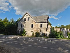
The former Nimmersatt Kurhaus (2017)
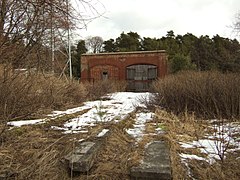
Shed of the sea rescue station (status 2011)
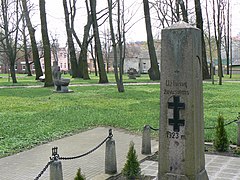
Former border stone of the German Empire, rededicated as a Lithuanian memorial
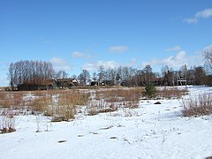
Hungry Winter 2011
.jpg)


See also
Individual evidence
- ↑ “Nemirsetos kurhauzo pastatas” with a Lithuanian description and a number of current photos
- ↑ Numerous pictures and map excerpts from Nimmersatt at Genwiki
- ↑ Nemirsetos laivų Gelbėjimo stotis , illustrated
- ↑ Melno sutartimi nustatytos LDK valstybinės sienos atkarpa II , illustrated
- ↑ It is astonishing that "Nimersat" is north of the border on a French map from 1659
- ↑ Map forum with overlaid historical maps
- ↑ Grenzgraben access at 55 ° 53 ′ 37.5 ″ N , 21 ° 3 ′ 40.4 ″ E
- ↑ Melno sutartimi nustatytos LDK valstybinės sienos atkarpa II , illustrated.