Center of Switzerland

from Wikipedia, the free encyclopedia
Marking of the geographical center of Switzerland

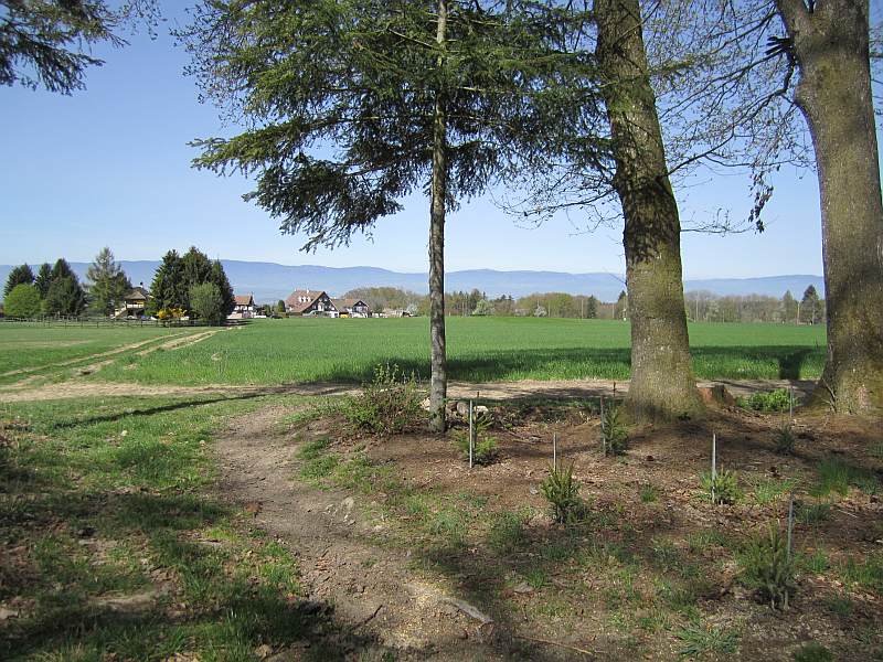
The center of Switzerland is on the Älggi-Alp in the canton of Obwalden . It was determined as the geographical center point in 1988 on the occasion of the 150th anniversary of the Federal Office for Topography.

Geographic center

Geographical center of Switzerland

The geographical center is actually the center of gravity . The calculation was carried out as a moment calculation with regard to the x and y axes for a closed polygon . This geometric center of gravity is the point at which a needle would have to be placed in order to balance Switzerland evenly . Imagine a Swiss map on homogeneous cardboard that is cut off along the national borders . In order to balance this piece of cardboard with a needle, cardboard Switzerland must be supported precisely at the centroid. This is on the Älggi-Alp at the coordinates 660 158  /  183640 ( 46 ° 48 '4 "  N , 8 ° 13' 36"  O ) . As this point is difficult to access above the cliff of Chli-Älggi, a publicly accessible stone was placed 500 m further southeast. This symbolizes the center and has the coordinates 660 557  /  183 337 ( 46 ° 47 '54 "  N , 8 ° 13' 55"  O ) .

Every year from 2003 to 2015, the Swiss of the Year was honored at this point and the name was engraved on the existing plaque .

Most distant point

In the Silbermoos near Uetendorf lies the Swiss center of the circle or the point of Switzerland furthest from the border. This is the point at which you are furthest away from any national border in Switzerland. According to calculations that have been carried out June 2019 at Swisstopo, the Federal Office of Topography, this point is located in Swiss coordinates (LV03) at the coordinates 610 170  /  181300 ( 46 ° 46 '58 "  N , 7 ° 34' 19"  O ) and is 68,880 meters from the border. Older calculations of the point had given the coordinates 609778/181368.

There are various calculation methods that are derived from the GIS system. With one, a lot of points are calculated for the distance to the national border and the area is geographically limited. This procedure is repeated and refined several times in the newly calculated area, with much closer intervals, and the center point is thus determined incrementally. Another method is based on the national border and draws polygons with increasing distance to it. This is repeated until the point furthest from the border is found in the last remaining area.

Overview

Calculation method area Coordinates map
Centroid Älggi-Alp 660 158  /  183640 ( 46 ° 48 '4 "  N , 8 ° 13' 36"  O )
Center of Switzerland (Switzerland)
Red pog.svg
Symbolic center point Älggi-Alp 660 557  /  183 337 ( 46 ° 47 '54.4 "  N , 8 ° 13' 54.8"  O )
Center of Switzerland (Switzerland)
Red pog.svg
Grenzfernster point
incentre
Grenzfernster place in Switzerland
Silbermoos in Uetendorf 610.17 thousand  /  181300 ( 46 ° 46 '58 "  N , 7 ° 34' 19"  O )
Center of Switzerland (Switzerland)
Red pog.svg

Canton centers

Center of area Coordinates Hints
Kanton AargauKanton Aargau Aargau (AG) Wildegg- Hardhof 654.21 thousand  /  251 231 ( 47 ° 24 '34.8 "  N , 8 ° 9' 24.8"  O )
Canton of Appenzell AusserrhodenCanton of Appenzell Ausserrhoden Appenzell Ausserrhoden (AR) Haslen (Appenzell Innerrhoden) 745 718  /  247959 ( 47 ° 21 '58.9 "  N , 9 ° 22' 4.5"  O )
Canton of Appenzell InnerrhodenCanton of Appenzell Innerrhoden Appenzell Innerrhoden (AI) Appenzell 749 544  /  242595 ( 47 ° 19 '2.2 "  N , 9 ° 25' 0.3"  O )
Canton of Basel-CountryCanton of Basel-Country Basel-Country (BL) Lupsingen , Rüti 619894  /  255697 ( 47 ° 27 '6.3 "  N , 7 ° 42' 8.7"  O )
Canton of Basel-StadtCanton of Basel-Stadt Basel-City (BS) Basel-Hirzbrunnen 613 293  /  268 255 ( 47 ° 33 '53.5 "  N , 7 ° 36' 54.9"  O )
Canton BernCanton Bern Bern (BE) Schwand near Oberdiessbach 615111  /  185848 ( 46 ° 49 '25 "  N , 7 ° 38' 12"  O )
Canton of FriborgCanton of Friborg Freiburg (FR) Farvagny-le-Grand 572 122  /  174197 ( 46 ° 43 '6.2 "  N , 7 ° 4' 26.4"  O )
Canton of GenevaCanton of Geneva Geneva (GE) Moillebeau, Petit-Saconnex et Servette 499 254  /  119627 ( 46 ° 13 '13.9 "  N , 6 ° 7' 58.6"  O )
Canton of GlarusCanton of Glarus Glarus (GL) Bag forest, Tannenberg 723 788  /  204 613 ( 46 ° 58 '51.8 "  N , 9 ° 3' 56.7"  O )
canton of Grisonscanton of Grisons Graubünden (GR) Crap Furo , Surava 767 576  /  169 562 ( 46 ° 39 '22.5 "  N , 9 ° 37' 41.5"  O ) Crap Furo, aerial photography 5.jpg
Canton of JuraCanton of Jura Law (JU) Les Planches-en-Montagne , Pruntrut district 578 653  /  244471 ( 47 ° 21 '2.7 "  N , 7 ° 9' 22"  O )
Canton lucerneCanton lucerne Lucerne (LU) Althus, Ruswil 651012  /  213189 ( 47 ° 4 '3.9 "  N , 8 ° 6' 36.7"  O )
Canton of NeuchâtelCanton of Neuchâtel Neuchâtel (NE) Le Plandrion, Rochefort , District de Boudry 549 913  /  205153 ( 46 ° 59 '43.9 "  N , 6 ° 46' 48.5"  O )
Canton of NidwaldenCanton of Nidwalden Nidwalden (NW) Niederrickenbach , Wolfenschiessen 673.62 thousand  /  197 748 ( 46 ° 55 '36.3 "  N , 8 ° 24' 19.1"  O )
Canton of ObwaldenCanton of Obwalden Obwalden (OW) Glotersegg, Sachseln 661 443  /  189581 ( 46 ° 51 '16.3 "  N , 8 ° 14' 39.5"  O )
Canton of SchaffhausenCanton of Schaffhausen Schaffhausen (SH) Ringing 686 528  /  285410 ( 47 ° 42 '48.9 "  N , 8 ° 35' 30"  O ) Center of the canton of Schaffhausen.JPG
Canton of SchwyzCanton of Schwyz Schwyz (SZ) Gschwändwald, municipality of Oberiberg 700 119  /  213147 ( 47 ° 3 '42.4 "  N , 8 ° 45' 23.7"  O )
Canton of SolothurnCanton of Solothurn Solothurn (SO) Wilkmatt, Matzendorf 615 183  /  239270 ( 47 ° 18 '14.9 "  N , 7 ° 38' 21.8"  O )
Canton of St. GallenCanton of St. Gallen St. Gallen (SG) Krummenau , Nesslau 739 029  /  232990 ( 47 ° 13 '59.5 "  N , 9 ° 16' 29.1"  O )
Canton of TicinoCanton of Ticino Ticino (TI) Cima alla Piode ob Brione, Verzasca 705 582  /  128055 ( 46 ° 17 '44.2 "  N , 8 ° 48' 32.1"  O )
Canton of ThurgauCanton of Thurgau Thurgau (TG) Weinfelden 724 405  /  269978 ( 47 ° 34 '7.4 "  N , 9 ° 5' 31"  O )
Canton of UriCanton of Uri Uri (UR) Am Leutschachbach, Intschi , Gurtnellen 690 885  /  180 763 ( 46 ° 46 '18.7 "  N , 8 ° 37' 42.9"  O )
Canton of VaudCanton of Vaud Vaud (VD) Les Planches , District de Lausanne 540 138  /  157945 ( 46 ° 34 '12.3 "  N , 6 ° 39' 28.1"  O )
Canton of ValaisCanton of Valais Valais (VS) Gillou, Anniviers , Sierre 612 812  /  117582 ( 46 ° 12 '34.4 "  N , 7 ° 36' 16.8"  O )
Canton of ZugCanton of Zug Train (ZG) Berghof, train 683 313  /  223 508 ( 47 ° 9 '26.3 "  N , 8 ° 32' 14.3"  O )
Canton ZurichCanton Zurich Zurich (ZH) Brütten 691 804  /  252038 ( 47 ° 24 '45.9 "  N , 8 ° 39' 18.3"  O ) Brütten survey point 1912.jpg
Center of Switzerland (Switzerland)
AI
AI
BE
BE
BL
BL
BS
BS
FR
FR
GE
GE
GL
GL
GR
GR
JU
JU
LU
LU
NE
NE
NW
NW
OW
OW
SG
SG
SH
SH
SO
SO
SZ
SZ
TG
TG
TI
TI
UR
UR
VD
VD
VS
VS
AR
AR
SG
SG
SO
SO
TG
TG
VD
VD
VS
VS
ZG
ZG
ZH
ZH
Switzerland Switzerland
SwitzerlandSwitzerland Switzerland
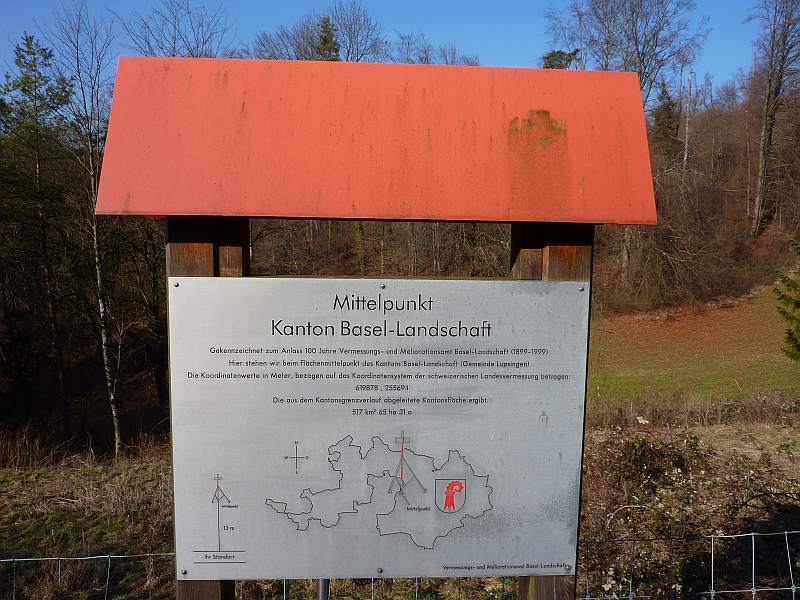
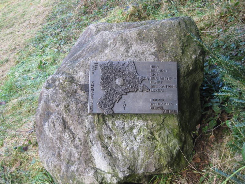
Centers of the cantons, central Switzerland and the whole of Switzerland.
Abbreviations see table above
  • Remarks
  1. The center (focus) of Appenzell Ausserrhoden has not been marked as it is located in the canton of Appenzell Innerrhoden . In the meadow above the road and wall between Haslen and Vordergass (opposite the yellow house) is the geographical center of the canton of Appenzell Ausserrhoden.
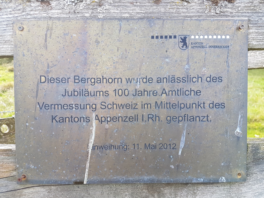
  2. Maple tree at Schlössli Unterrain, south of Appenzell, 870 m. ü. M. ( Photo on wandersite.ch)
  3. In Remischberg, northeast of Lupsingen ; Information board in the clearing
  4. ↑ Side street at the St. Clara Hospital not far from Basel Badischer Bahnhof Photo "Im Heimatland"
  5. At the Falkenfluh monument, near the departure ramp for the paragliders, photo
  6. Bench with a view of the center in the meadow (unmarked)
  7. ^ Chemin des Genêts , near the UN, west of Genève Cornavin main station
  8. Between Schlattberg and Tannenberg, east of Haslen
  9. 213 m east-southeast of the Crap Furo is the geometric center of the canton of Graubünden (767576/169562) [2]. If you spear the canton on a needle in such a way that it remains in suspension, the tip of the needle protrudes from the ground in Crap Furo
  10. a b c focus
  11. In Ravines, south of St-Ursanne
  12. East of Althus, on the western edge of the Schächbüelwald, Ruswil community, photo
  13. North of the Col de la Tourne
  14. Between Niederrickenbach Station and Niederrickenbach Dorf, photo triangulation point Nidwalden
  15. Focus, since October 16, 2009 with information board
    Obwalden is now digital. In: Neue Obwaldner Zeitung , October 22, 2009, p. 21.
  16. Lütisalp between Stockberg and Santis , in the easternmost part of the community Krummenau
  17. Memorial plaque : 10 km south at the church of Mergoscia , photo
  18. ^ At the "forest school room" in the Underau forest near Weinfelden
  19. Memorial stone 110 m northwest on the Alp Chäserli in the Leutschachtal Photo of the memorial stone
  20. Chalet des Enfants and Chalets aux Boeufs, southeast of Cugy , photo
  21. Mayens de Gillou below Hotel Weisshorn, Saint-Luc , photo: center of Valais
  22. Sennhütte above blister mountain on the Zugerberg

See also

Web links

Individual evidence

  1. The center of Switzerland celebrates its 20th anniversary , press release Federal Office of Topography swisstopo, June 4, 2008, accessed on February 25, 2019
  2. The center of Switzerland ( Memento of the original from June 6, 2016 in the Internet Archive ) Info: The archive link was inserted automatically and has not yet been checked. Please check the original and archive link according to the instructions and then remove this notice. , accessed June 6, 2016 @1@ 2Template: Webachiv / IABot / steinmanndli-klub.ch
  3. Marc Imboden: Second center of Switzerland is in the Oberland. In: Thuner Tagblatt , November 15, 2010
  4. State center Silbermoos on the Uetendorf website
  5. Source: Dr. Urs Marti, Surveying Department, Federal Office of Topography, SWISSTOPO
  6. Source method: Federal Office of Topography , SWISSTOPO , Surveying Department