
Crap Furo
| Crap Furo | ||
|---|---|---|
 |
||
| height | 1204 m above sea level M. | |
| location | Canton of Graubünden , Switzerland | |
| Mountains | Albula Alps | |
| Dominance | 0.081 km → Piz Mitgel | |
| Notch height | 80 m | |
| Coordinates | 767 386 / 169 658 | |
|
||
| First ascent | Hans Steger and Paula Wiesinger in the 1930s | |
 Crap Furo from the north |
||
|
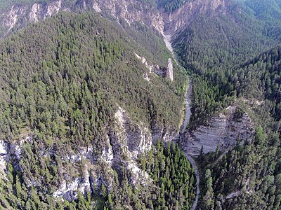
Aerial view of the Crap Furo. |
||


The Crap Furo ( Rhaeto-Romanic in the idiom Surmiran for pierced rock head ) is a conspicuous rock disc southeast of Surava , southwest of Alvaneu Bad and north of Piz Mitgel in the canton of Graubünden in Switzerland with a height of 1204 m above sea level. M. From the north it appears as a sharply pointed needle, from the west as a wide wall, broken through by two rock windows lying one above the other, the upper eye of the needle measuring 2 meters. The Crap Furo consists of Rauwacke , a converted, porous sedimentary rockcontaining water-soluble gypsum. The hole was created by washing out.
The Crap Furo is only 213 m west-northwest of the geometric center of the canton of Graubünden.
Location and surroundings

The Crap Furo belongs to the Bergüner sticks , a subgroup of the Albula Alps . It is located on the northern slope of Piz Mitgel in the area of the village Surava , which belongs to the municipality of Albula / Alvra .
The Crap Furo is located in the Crap Furo natural forest reserve . The natural forest reserve has a size of 120 ha. 110 ha of which are planted. The objectives of the natural forest reserve are the preservation of the mountain pine forests , the protection and promotion of rare plant and animal species as well as long-term observation of forest development and natural dynamics without forest interventions . In the natural forest reserve, therefore, no trees may be felled and no wood may be collected, no grazing may take place and there are trails in the winter half-year (from November 1st to April 30th). This was decided in 2008 in a 50-year contract between the communities of Alvaneu and Surava and the canton of Graubünden. Nevertheless, measures for the safety and maintenance of the tourist infrastructure, hunting and collecting berries and mushrooms are permitted within the framework of the applicable law.
The Crap Furo is also located in Parc Ela , a regional nature park that includes 19 communities in the Albula and Oberhalbstein valleys .
The Crap Furo is often reached from Surava or Alvaneu Bad via the trail of the pioneers.
Center of Graubünden
213 m from the east-southeast Crap Furo is the geometric center of the Grisons ( 767 576 / 169 562 ). If you spear the canton on a needle in such a way that it remains in suspension, the tip of the needle protrudes from the ground in Crap Furo.
Path of the Pioneers

The path of the pioneers leads from Surava ( 896 m ) on Crap Furo pass ( 1125 m ) to sulfur source Arvadi ( 960 m ), the healing and alchemical attributed skills. After the source, the hiking trail leads back to Surava along the Albula . Alternatively, you can also go to Alvaneu Bad ( 938 m ).
Along the path there are 13 specially marked information stops that provide interesting information about the development of the mountain forest and the pioneering achievements of man and nature. There is a barbecue area near the Crap Furo and a playground in both Surava and Alvaneu Bad .
The entire path takes about 2 hours.
First ascent
There are contradicting information about the first ascent. Some sources say that Hans Steger and his partner Paula Wiesinger first climbed the needle in the 1930s. Henry Hoek describes in his "Berg- und Wanderbuch Davos", published in 1934, that Steger climbed the Crap Furo themselves with the help of PL Edwards and Hoek. Wooden wedges and loops of this first ascent have remained in the rock to this day.
- Henry Hoek describes the ascent in his book as follows: “A single hook at a height of 4 meters holds - no one else wants to pack. Nothing is to be wanted with steel: the crack is too deep and too wide. […] For the next two hours we saw ourselves busy carving wedges from hard and tough pine wood and tying the ends of the rope for the carabiners . Steger gets in again. And it turns out that the wedges hold very well. But it takes one for almost every half meter. [...] After four hours the wedges are used up, Steger breaks off the ascent. […] We drive to Chur , spend the night and have beautiful hardwood wedges made by the carpenter and long iron hooks by the locksmith. […] Two days later: The new beech wedges prove their worth and after an hour the lower, smaller hole is reached. But beyond that, despite all attempts, it doesn't work. So through the hole! However, this is so narrow that various rock corners have to be cut off before it can slip through. At the window below the beginning of the gap, the climbing stops again. First the gap must be closed with a wooden wedge. Standing on Edward's shoulders, Steger gets to work. After many attempts, a wedge is finally in place. [...] After 10 hours of strenuous scrambling, Steger is the only one to reach the summit. The ascent did not go unnoticed: In Surava down in the valley they stood for hours on the country road, with a protective hand over their eyes, with old binoculars and our charioteer's Zeiss. They stared up at the crap and enjoyed every detail of the fight. "( Henry Hoek : Davos. A mountain and hiking book. Hamburg 1934)
Routes to the Crap Furo
The western foot of the monument can be reached via the path of the pioneers in ¾ hours from Surava ( 896 m ) and in 1¼ hours from Alvaneu Bad ( 957 m ). The path is marked as a white-red-white hiking trail . From there you climb on the mountain side along the foot of the wall to the large crack, from where you climb on an exposed route in not particularly good rock along a wide crack through the east wall. Through the lower rock window you change to the west wall and reach the ridge cutting edge. Difficulty: AS , V + , A1
gallery
The Crap Furo over the rock.

The Crap Furo from the east.
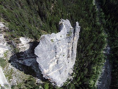
The Crap Furo from above.

Information board for the trail of the pioneers in Surava.
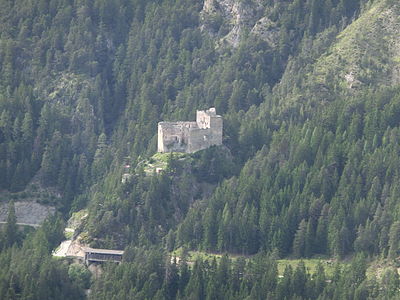
View from Crap Furo to the northwest to Belfort Castle .


literature
- Manfred Hunziker: Club Guide, Bündner Alpen, Volume VI (From Septimer to Flüela). 3. Edition. Verlag des SAC, 2000, ISBN 3-85902-187-7 , pp. 200-202.
- National map of Switzerland, sheet 1216 Filisur, 1: 25000, Federal Office of Topography, 2011 edition.
- National map of Switzerland, sheet 1236 Savognin, 1: 25000, Federal Office of Topography, 2011 edition.
Web links
Individual evidence
- ↑ Crap Furo natural forest reserve . Website from the Office for Forests and Natural Hazards of the Canton of Graubünden. Retrieved on August 12, 2015 (PDF; 251 kB).
- ↑ Some figures on the canton of Graubünden ( Memento of the original from March 4, 2016 in the Internet Archive ) Info: The archive link was inserted automatically and has not yet been checked. Please check the original and archive link according to the instructions and then remove this notice. . Website of the Office for Agriculture and Geoinformation of the Canton of Graubünden. Retrieved August 12, 2015.
- ↑ A peripheral region with a pioneering spirit . Website of the magazine, of course . Retrieved on August 12, 2015 (PDF; 1.36 MB).
- ↑ Flyer Path of the Pioneers . Park Ela website. Retrieved on August 12, 2015 (PDF; 2.85 MB).
- ↑ Manfred Hunziker: Club Guide, Bündner Alpen, Volume VI (From Septimer to Flüela). 3. Edition. Verlag des SAC, 2000, ISBN 3-85902-187-7 .
- ↑ Nature Knowledge - Crap Furo . Website from natur-lexikon.de. Retrieved August 12, 2015.
- ↑ Parc Ela: nature park in the heart of Graubünden . Page of the broadcast SRF bi de Lüt Wunderland from June 20, 2014 on the SRF website . Retrieved August 12, 2015.