
Mulda / Sa.
| coat of arms | Germany map | |
|---|---|---|

|
Coordinates: 50 ° 49 ' N , 13 ° 24' E |
|
| Basic data | ||
| State : | Saxony | |
| County : | Central Saxony | |
| Height : | 424 m above sea level NHN | |
| Area : | 43.14 km 2 | |
| Residents: | 2464 (Dec. 31, 2019) | |
| Population density : | 57 inhabitants per km 2 | |
| Postal code : | 09619 | |
| Area code : | 037320 | |
| License plate : | FG, BED, DL, FLÖ, HC, MW, RL | |
| Community key : | 14 5 22 390 | |
| Address of the municipal administration: |
Main street 59 09619 Mulda / Sa. |
|
| Website : | ||
| Mayor : | Reiner Stiehl | |
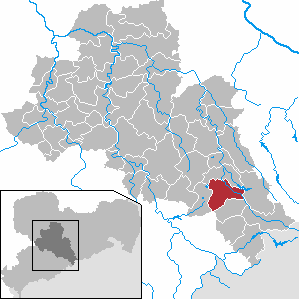
| Location of the municipality of Mulda / Sa. in the district of central Saxony | ||
  |
||

Mulda / Sa. ( Mulda / Saxony ) is a municipality in the Saxon district of Central Saxony .
geography
Mulda is about 10 kilometers south of Freiberg on the northern slope of the Ore Mountains in the valley of the Freiberger Mulde , which flows through the place from southeast to northwest. The Chemnitzbach and the Zethaubach both flow into the Freiberg Mulde from the left.
Community structure
To Mulda / Sa. In addition to the main town of Mulda, the following districts belong:
- Helbigsdorf (incorporated January 1, 1994)
- Randeck (incorporated on August 1, 1934)
- Zethau (incorporated January 1, 1994)
Neighboring communities
The municipalities of Dorfchemnitz in the south, Olbernhau in the southeast, the city of Frauenstein in the east, Lichtenberg in the north, Großhartmannsdorf in the west and Olbernhau in the southwest border Mulda .
history


Mulda was probably founded as a Waldhufendorf by Franconian settlers between 1160 and 1260 . In 1331 a Petrus de Mulda was mentioned, the place itself was mentioned in 1333 in a paper from the city of Freiberg as Mulda . In 1419 the Burgrave of Meißen was granted higher jurisdiction in a feudal letter. In the past, the residents of Mulda mainly farmed and raised livestock, mainly flax.
In Helbigsdorf, sheep were raised on a large scale. According to the chronicle, a few hosiery, clock and violin makers lived there in 1710.
Randeck is considered to be the oldest watchmaker and violin maker village in the Ore Mountains. In the 19th century, instrument making gave way to basketry and wood products. Many oil and grinding mills were once in operation on the Mulde and its numerous tributaries. In the time of the Thirty Years' War was Freiberg besieged twice and also in Mulda several houses and the manor were burnt down by the Swedes. Up until 2005, a walled-in cannon ball in the now collapsed fiefdom testified to the shelling of "Prussian peoples" (inscription below the ball) during the Seven Years' War . Again, under General Kleist, seven farms and six houses were burned down. The previously independent manor came to Mulda in 1920. On August 1, 1934, Randeck was incorporated. The community was called Mulda-Randeck until 1941, and then again Mulda from January 25, 1941.
Today the structural transition between Mulda and Randeck can hardly be seen. On January 1, 1994, Zethau and Helbigsdorf became districts of Mulda.
When the Freiberg Mulde also led extreme floods in August 2002 during the so-called “ flood of the century ”, great damage was done in the area.
Population development
In 1551, 28 possessed men and 106 residents ran in Mulda . Within the next 30 years the population decreased, so that in 1581 there were still 24 possessed men and 47 cottagers . Until the middle of the 18th century this number hardly changed, 20 possessed men and 50 cottagers were counted.
|
|
|
|
||||||||||||||||||||||||||||||||||||||||||||||||||||||||
1990: Status as of October 3rd, from 1991 status to December 31st, source: State Statistical Office of the Free State of Saxony
politics
Municipal council
Since the municipal council election on May 26, 2019 , the 14 seats of the municipal council have been distributed among the individual groups as follows:
mayor
Reiner Stiehl was elected mayor in 2007 with 97.9% of the vote and was confirmed in office in 2014 with 98.8 percent.
coat of arms
Blazon : “Divided by Göbelschnitt; in front three silver organ pipes in red, behind in gold three blue flax flowers, the middle one offset inwards, each with five petals and a golden lug, below in silver growing from a blue wave shield base a black mill wheel, in the wave shield base five 3: 2 standing silver waves. "
The coat of arms was designed in 2012 by the municipal heraldist Jörg Mantzsch . The aim of creating its own coat of arms was to represent all three districts together. This means that the Silbermann organ stands for Helbigsdorf, the flax or linseed cultivation for Zethau and the use of water power along the Freiberg Mulde for Mulda.
Culture and sights

The organ of the church in Helbigsdorf was completed in 1728 by the organ builder Gottfried Silbermann and impresses with its brilliant sound.
A grave in the Mulda local cemetery commemorates a Soviet slave laborer known by name who was deported to Germany during the Second World War .
In the Frauenstein state forest district ( forest division 91), 2.5 km southeast of the Mulda church, the remains of the Mulda moated castle and the deserted village of Gruene are located in a slightly northeast sloping terrain above the western steep slope of the Freiberg Mulde .
Economy and Infrastructure

Before the railway was built in 1875–1884, several mills, flax cultivation, several yarn and canvas bleaching and handicrafts were known in Mulda. Violin and watchmaking trades existed in what is now Randeck. Industry also found its way through the railroad - wood processing companies in particular shaped the place until German reunification in 1990. A traditional company that survived this phase of upheaval is the Berlebach wooden tripod manufacturer, founded in 1898 .
Mining was also carried out until 1754, but the yields were low. The remains of an overburden dump can still be found in the Randeck district at the exit towards Zethau .
traffic
_um_1907.jpg&filetimestamp=20110901120419&)
_um_1907.jpg&filetimestamp=20110901120419)
Mulda is on the Nossen – Moldau railway line . From 1897 to 1966, Mulda was the starting point for the Mulda – Sayda narrow-gauge railway . In Mulda station , goods and people could be transferred from the regular lane.
Educational institutions
For grades 1 to 4 there is a primary school in Mulda with all-day courses.
Personalities
- Friedrich Klemm (1904–1983), technology historian and library director of the Deutsches Museum in Munich
- Kurt Möbius (1908–1993), chemist and fire department official
literature
- Mulda, Mulde . In: August Schumann : Complete State, Post and Newspaper Lexicon of Saxony. 6th volume. Schumann, Zwickau 1819, pp. 634-638.
- The Mulda Parish. in: G. Buchwald (Ed.): New Saxon Church Gallery, Ephorie Freiberg. Strauch Verlag, Leipzig 1901, Sp. 353-368 ( digitized version ).
- Summer health resort Mulda (station of the Freiberg-Bienenmühle line) - some notes for orientation . Mauckisch, Freiberg 1885 ( digitized version ).
- Richard Steche : Mulda. In: Descriptive representation of the older architectural and art monuments of the Kingdom of Saxony. 3. Issue: Amtshauptmannschaft Freiberg . CC Meinhold, Dresden 1884, p. 110.
Web links
- Atlas Central Saxony
- Mulda / Sa. in the digital historical directory of Saxony
Individual evidence
- ↑ Population of the Free State of Saxony by municipalities on December 31, 2019 ( help on this ).
- ^ The Sachsenbuch, Kommunal-Verlag Sachsen KG, Dresden, 1943, pages 237, 239
- ^ The Sachsenbuch, Kommunal-Verlag Sachsen KG, Dresden, 1943, page 237
- ↑ Mulda / Sa. in the digital historical directory of Saxony
- ↑ Results of the 2019 municipal council elections
- ↑ Muldaer Anzeiger , official gazette of the municipality Mulda / Sa. September 2012, page 1.
- ↑ Wüstung Grün in the Digital Historical Directory of Saxony
- ↑ Michael Kirchner: Schmalspur-Album Sachsen. 11. Deutsche Reichsbahn [1920–1945]: Goßdorf-Kohlmühle, Hohnstein, Mulda-Sayda, Hetzdorf-Großwaltersdorf, Thumer route network, Wolkenstein-Jöhstadt . Fürstenfeldbruck 2011, ISBN 978-3-00-035950-7 .