Dyleň
| Dyleň | |
|---|---|
|
View to Tillenberg from Bad Neualbenreuth |
|
| height | 939 m |
| location | Czech Republic |
| Mountains | Upper Palatinate Forest |
| Coordinates | 49 ° 58 '5 " N , 12 ° 30' 11" E |
| Development | 1926 Construction of a mountain hut by the DAV section Eger |
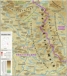
The 939 m high Dyleň ( German Tillenberg or Tillen ) is the second highest elevation in the Upper Palatinate Forest .
It is located in the corridors of the Stará Voda community east of Bad Neualbenreuth in Bavaria . The Bavarian-Czech border runs northwest about 500 meters away and about a hundred meters below the summit.
history
In old reference works, the Dyleň is considered to be the highest point in the Upper Palatinate Forest; Sometimes, however, the Entenbühl is also mentioned in various lexicons , which is about 25 kilometers further south. Nowadays, however, it has been proven that the Čerchov in the south of the Upper Palatinate Forest is the highest elevation.
At the time of the Austro-Hungarian monarchy, Austrian geographers calculated the Tillen as the geographical center of Europe . At that time they documented this on a copper plate that they attached to the summit. The town of Bad Neualbenreuth on the German side mentions this in its tourism advertisement.
The monuments to the center of Europe are located on an old border path, which today marks the German-Czech border. The Garnet Fountain and the Königsstein are in the immediate vicinity .
In 1926 the German Alpine Club , Eger section, built a club shelter, the Tillenschutzhaus, on the mountain. This was dismantled by the Czech side after the Second World War and transported to Pilsen .
In the 1960s, Czechoslovakia built a military reconnaissance station on the large summit area, which lost its authorization after the end of the Cold War in 1989. Today there are transmitting antennas of Czech radio stations on the top.
In 1964 a uranium ore lens was discovered at Tillenberg and search work began in the open pit. After the drilling of two shafts, which reached a depth of 1003 and 1258 meters, the uranium mines in West Bohemia began mining in 1966, which lasted until 1991. Uranium was mined in 18 levels. A total of 100,150 employees worked on the Tillenberg. From the 786,706 tons of uranium ore mined, 1121 tons of pure uranium were extracted. The summit of the mountain is still fenced in with barbed wire and cordoned off so that you cannot reach the summit plateau.
Say
There are numerous legends about this mountain, about the mountain spirit that lives in it or about the headless woman. Stories were also told about the dwarves who were there looking for grenades and other precious stones. The town of Tillen is said to have once stood here, but it was cursed and sunk in the ground because of the decaying morality of its residents. A fortune teller by the name of Sibylle Weis also appears in some Tillensages. Her first name was used for the nearby Sibyllenbad in the Tirschenreuth district , the first and so far only spa and medicinal bath in the Upper Palatinate.
In the nearby Bad Neualbenreuth, stories and fairy tales about the Tillenberg are depicted at the Sagenbrunnen on the market square, next to the Sibyl of Prague dwarfs and mountain spirits and the mysterious Tillenstadt.
Transmitter
In the early 1990s, the radar station on the summit lost its importance. Parts of the plant were removed. The tower has been renovated and serves as a transmitter for radio and television programs. In the VHF range, the private radio Egrensis broadcasts from Cheb on 92.5 MHz. In addition, the following state programs are broadcast: CR1 97.6 MHz; CR Regional Karlovy Vary 100.8 MHz. Because the mountain is near the border with Germany, the programs can also be received in parts of Upper Franconia and the Upper Palatinate. Radio Egrensis transmits with 5 kilowatts and can therefore also be received at higher altitudes around Regensburg, 110 kilometers away.
Web links
Individual evidence
- ↑ a b Topographic map 1: 25,000. State Office for Digitization, Broadband and Surveying, Munich, accessed on March 15, 2015 .
- ↑ The near-border radio and radio technology reconnaissance on the Dyleň
- ↑ Uranium mining at Tillenberg ( Memento of the original from February 21, 2006 in the Internet Archive ) Info: The archive link was inserted automatically and has not yet been checked. Please check the original and archive link according to the instructions and then remove this notice.


