
Entenbühl
| Entenbühl | ||
|---|---|---|
 Summit of the Entenbühl |
||
| height | 901 m above sea level NHN | |
| location | Neustadt an der Waldnaab district , Bavaria , Germany | |
| Mountains | Upper Palatinate Forest | |
| Coordinates | 49 ° 45 '28 " N , 12 ° 23' 53" E | |
|
||
| rock | Gneiss | |
| particularities | highest point in the district of Neustadt an der Waldnaab | |

The Entenbühl is 901 m above sea level. NHN high mountain in the Upper Palatinate Forest in Bavaria .
Geographical location
It is located northeast of the municipality of Flossenbürg in the Bavarian district of Neustadt an der Waldnaab , less than a kilometer from the Czech border. The Havran ( 894 m ) rises south in the Czech Republic .
The Entenbühl is after the 938 m high Kreuzfelsen ( Gibacht ) the second highest elevation in the German part of the Upper Palatinate Forest. On the Czech side, the Čerchov (Schwarzkopf) and the Dyleň (Tillenberg) reach greater heights. In addition, the Entenbühl is the highest point in the Neustadt an der Waldnaab district. In the Tirschenreuth district , on whose border the Entenbühl lies, there is a higher mountain, the Platte ( 946 m ), which, however, lies in the southern Fichtelgebirge / Steinwald .
Attractions
Below the summit is the Hubertus Chapel, a war bunker built in 1938 and redesigned into a chapel by the Upper Palatinate Forest Association in 1998 , as well as a wooden summit cross erected in 2000.
The cross-country skiing center Silberhütte extends around the mountain on the German side .
The summit area is also the location of a trigonometric point .
photos
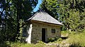
Hubertus Chapel

Wooden relief in the Hubertus Chapel

Summit cross


Individual evidence
- ↑ Location map 1: 10,000. In: BayernAtlas of the Bavarian State Government. Retrieved March 21, 2016 .
- ↑ Map services of the Federal Agency for Nature Conservation ( information )