Kreuzfelsen (Upper Palatinate Forest)
| Cross rock | ||
|---|---|---|
|
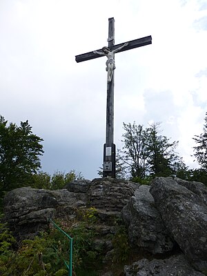
Cross rocks with rock formation and summit cross |
||
| height | 938 m above sea level NHN | |
| location | District of Cham , Bavaria , Germany | |
| Mountains | Upper Palatinate Forest | |
| Dominance | 3.3 km → Dlouhá Skála | |
| Notch height | 92 m ↓ approx. 1.8 km north-north-west of the summit at the German - Czech border point 11 not far from the Knock hill . | |
| Coordinates | 49 ° 20 '24 " N , 12 ° 47' 7" E | |
|
|
||
| particularities | highest peak in the German part of the Upper Palatinate Forest | |
The Kreuzfelsen is 938 m above sea level. NHN the highest point in the German part of the Upper Palatinate Forest . On its summit there is a striking rock formation and on top of it a large summit cross on which a figure of Christ is attached.
geography
location
The Kreuzfelsen is located in the southern Upper Palatinate Forest in a mountain range that is called Gibacht in the region based on the settlement of the same name not far from the summit . It is located on the so-called Glass Road between Waldmünchen and Furth im Wald in the Upper Palatinate district of Cham . Its highest point is on the Furth im Wald area, about 600 m from the German - Czech border . Other peaks that exceed the 900 m height line in the Gibacht are the Tannenriegel ( 934 m ) with the 929.7 m high Riegelbaum secondary peak , the Dreiwappen (with penny rocks) ( 917 m ) and the 902 m high Reiseck . The closest localities are the Waldmünchener districts of Pucher in the northwest and Althütte with the district Gibacht in the southwest and Voithenberg, a district of Furth im Wald in the southeast.
The next higher elevation is the 3.6 km north in the Czech Republic , 969 m above sea level. NHN high Dlouhá Skála (German Langenfels ), a pre-summit of Čerchov (German Schwarzkopf ), 1.5 km further northeast, also in the Czech Republic . This is 1042 m above sea level. NHN is also the highest mountain in the Upper Palatinate Forest .
On the northeast slope of the mountain massif, several tributaries of the Ulrichgrünerbach arise as a tributary to the Schwarzach , on the southwest flank several tributaries of the Hüttenbach and Bogenbach (later Hühnerbach ) and on the southeast slope of the Ölbrunnbach and several tributaries of the Kalten Pastritz all as tributaries to the Chamb .
Natural allocation
The Kreuzfelsen belongs in the natural spatial main unit group Upper Palatinate-Bavarian Forest (No. 40) to the main unit Upper Upper Palatinate Forest (400).
Traffic and walking
From Waldmünchen in the north or Furth im Wald in the south you can reach the Kreuzfelsen on the CHA 40 district road , which you follow to Althütte. From here a cul-de-sac leads to the Gibacht district, which is just a few houses in size, with a parking lot for hikers at the Gibacht mountain inn of the same name . From here, the 5 km long Gibacht circular hiking trail opens up the entire mountain range.
Winter sports
The area around the Kreuzfelsen is mainly developed for winter sports from Furth im Wald. There is a small ski area with lifts on the southeast flank above the Voithenberg district . The mountain region is more important because of the cross-country skiing center Gibacht / Čerchov / Althütte , which offers several cross-country trails.
Web links
Individual evidence
- ↑ a b c d e Map services of the Federal Agency for Nature Conservation ( information )
- ↑ a b BayernAtlas of the Bavarian State Government ( notes )
- ↑ Photo from the sign on the summit cross of the Kreuzfelsen, on commons.wikimedia.org
- ↑ Location map 1: 10,000. In: BayernAtlas of the Bavarian State Government. Retrieved October 9, 2016 .
- ↑ Location map 1: 10,000. In: BayernAtlas of the Bavarian State Government. Retrieved October 9, 2016 .
- ↑ Gibacht circular hiking trail
- ↑ Winter magic in Furth im Wald

