
Slab (stone forest)
| plate | |
|---|---|
 View from the Kosseine to the Steinwald with Platte and Oberpfalzturm |
|
| height | 946 m above sea level NHN |
| location | Tirschenreuth district , Bavaria , Germany |
| Mountains | Steinwald , Fichtelgebirge |
| Coordinates | 49 ° 54 '36 " N , 12 ° 3' 11" E |
 |
|
| rock | granite |
| particularities | highest mountain in the Steinwald , Oberpfalzturm ( AT ) |
The plate in the Bavarian district of Tirschenreuth is 946 m above sea level. NHN the highest mountain in the Steinwald , a mighty granite ridge in the southern Fichtelgebirge . The striking Oberpfalzturm towers on the summit . It can be climbed over 150 steps and offers wide views of the surrounding area, in good weather you can even see the Saxon Ore Mountains and the Bavarian Forest .
Upper Palatinate Tower
The first Upper Palatinate Tower was inaugurated in 1972 and demolished in April 1998 because it was dilapidated. The second Upper Palatinate Tower was inaugurated on September 10, 2000, it has a total height of 35 meters, the viewing platform is 30 meters high.
Hiking around the plate
Several hiking trails lead to the plate. Probably the most famous path leads from the Hohenhard hiking car park ( 778 m ), the Weißenstein ruins ( 863 m ), the ecumenical Trinity Chapel and the castle rock ( 913 m ) on the Steinwaldkamm to the Platte. Another of the numerous paths begins above the former Zrenner mountain inn at the new information portal with children's playground in Pfaben . This leads along the signposted forest trail past the managed forest house ( 822 m ) with deer enclosure and stone forest mushroom (storage facility).
climate
The first snow usually falls on the slab in October, the last in April / May. It's rough here in the ridges. The total precipitation in one year is 1100 mm, a third of which falls as snow. The mean temperature in July is around 13.5 ° C, the mean annual temperature around 4 ° C.
photos
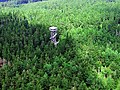
The Upper Palatinate Tower from the air

Summit sign: Location Platte 946 m highest mountain in the Steinwald

Winter on the slab in the stone forest. View from the icy platform of the Upper Palatinate Tower


