
Kitchenette
| Kitchenette | |
|---|---|
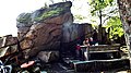
 View from the Großer Haberstein to the Kosseine |
|
| height | 939 m above sea level NHN |
| location | Bavaria , Germany |
| Mountains | Fichtel Mountains |
| Coordinates | 49 ° 59 '16 " N , 11 ° 58' 47" E |
 |
|
| rock | granite |
| particularities |
|
The Kosseine is a mountain range in the Fichtelgebirge and is located in northeast Bavaria south of Wunsiedel . The highest elevation of the granite mountain is the summit of the same name at an altitude of 939 m above sea level. NHN . Approx. 350 m to the northeast is the 922 m above sea level. NHN high side knoll Kleine Köseine . The border between the administrative districts of Upper Franconia and Upper Palatinate and the European watershed between the North Sea and the Black Sea run across the Kosseine . The towns of Wunsiedel, Marktredwitz , Bad Alexandersbad , Waldershof , Hohenhard, Neusorg , Brand , Ebnath , Nagel and Tröstau , all of which are known as tourist destinations, are located around the Köseine .
Naturally , it belongs to the main unit of the Hohes Fichtelgebirge (394). Since September 2010 there has been a new design of the natural areas of northeast Bavaria, according to which the Kosseine is part of a more finely defined sub-unit of the High Fichtel Mountains (in the narrower sense) .
natural reserve
In the summit area of the Kosseine there is an extensive granite block sea with an area of 15.8 hectares, which is under nature protection. Various rock groups ( Kleine Kosseine , Großer and Kleiner Haberstein , Burgsteinfelsen , Mühlstein, Püttners- and Jakobifels) are protected natural monuments. The double summit of the Kosseine, which is visible from almost all sides, is striking.

history
The Kosseine was first mentioned in a document on March 7, 1283, when large areas of the Kosseine (Choezsin) passed to Duke Ludwig the Strict, Count Palatine of the Rhine and Duke in Bavaria. The name Choezsin or Chozin is of Slavic origin and means goat mountain , probably a reference to the earlier cattle industry. From 1542 ( Caspar Bruschius : Des Vichtelberg's thorough description ) to the present day the mountain appeared in all regional books and was praised for its excellent view. The dense forests were a popular hunting ground for the Bayreuth margraves as early as the 15th century , the forests supplied firewood and construction wood for the surrounding areas, and granite mining began in the 15th century.
In 1785 and 1820 Johann Wolfgang von Goethe came to the Fichtel Mountains. He wrote scientific treatises on the weathering of granite and made drawings of various rock formations in the Kisseine area.
Because of the open, wide view in all directions to the Bavarian Forest , the Rhön , the Thuringian Forest and the Ore Mountains , the mountain was a popular destination from an early stage. His fame increased significantly through the visit of the then sovereign rulers, who stayed in Alexandersbad from June 13, 1805 to July 5, 1805 . On June 17, 1805, Friedrich Wilhelm III. with wife Luise and a large entourage a ride to the kitchen. Many newspapers reported about it and thus promoted awareness of the mountain.
Buildings
A first primitive shelter was built in 1805, and a weather roof in 1833. In 1882 the Fichtelgebirge section of the German-Austrian Alpine Club (predecessor of the Fichtelgebirgsverein ) built a timbered refuge with food for hikers. Because of the steadily increasing number of visitors, a “permanent house” was required, which was inaugurated in 1903 after long preparations and significantly expanded in the following years. In 1924, instead of wooden towers, a stone lookout tower was built , the 6.43 m high Kösseineturm. The house and tower belong to the Fichtelgebirgsverein e. V., the year-round managed lodging house, which consists of Kosseine granite , is leased.
In the years 1998 to 2000 the Kosseinehaus was completely renovated so that it meets the modern requirements of a commercial enterprise. The forest road to the house is closed to public traffic, it can only be reached on foot. The Kßeinehaus is part of the main hiking trail network of the Fichtelgebirgsverein e. V. included; it is located directly on the Höhenweg and the Franconian mountain path .
Volunteers of the Fichtelgebirgsverein e. V. have laid out 13 marked hiking trails of different lengths from all directions to the Kosseine summit.
Waters
On the southeast drop in Kösseine, near the village Kössain, the creek rises Kössein (popularly also Kösseine called) formed by Waldershof and Marktredwitz flows and Seußen in Röslau , a tributary of the Eger , opens.

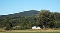
The Köseine seen from Hildenbach

The Pfalzbrunnen is located on the southern slope of the Kosseine, exactly on the border between Upper Franconia and the Upper Palatinate. The current version was established by the Fichtelgebirgsverein Waldershof in 1907

Blue granite from the kitchen, raw and polished

Kitchen house
Stone formation on the summit in front of the Kosseinehaus
The Kösseine of nail seen from


.jpg)


economy
The Kosseine granite , which is unique as a blue granite in Europe, is also called Kleinwendern granite or Schurbach granite and occurs in Schurbach and Kleinwendern . The deposit is located at the Luisenburg rock labyrinth north of the Kosseine in a narrow band that stretches to the east. Only the eastern parts of the lower rock labyrinth are made of Kosseine granite, the western parts are roof granite. Kosseine granite is only quarried in a quarry near Waldershof in the Tirschenreuth district .
Culture
For decades, the Berghaus on the Kosseine has been a meeting place for folk musicians who play authentic folk music there at regular intervals . Also home evenings are very popular. There is a large wooden cross and a stone altar near the Kosseinehaus; Mountain worship services on Ascension Day and on special occasions have a long tradition there.
literature
- Dietmar Herrmann: All about the Kosseine in the Fichtelgebirge in issue 18/2011 of the series Das Fichtelgebirge . Publisher: Fichtelgebirgsverein e. V.
Web links
Individual evidence
- ↑ a b c Map services of the Federal Agency for Nature Conservation ( information )
- ^ E. Meynen and J. Schmithüsen : Handbook of the natural spatial structure of Germany - Federal Institute for Regional Studies, Remagen / Bad Godesberg 1953–1962 (9 deliveries in 8 books, updated map 1: 1,000,000 with main units 1960)
- ^ Karl Heinrich Vollrath: Viola in Northeast Bavaria (page 132-133)
- ↑ The Kösseineturm . To Das Fichtelgebirge , accessed on December 6, 2014 (for the height of the tower, see the height information "Kossine" and "Tower" under a photo)

Breeding pond and breeding meadows near Neuhaus ad Eger | Egertal near Neuhaus | Summit of the Great Kosseine | Häuselloh | Small labyrinth | Luisenburg rock labyrinth | Wunsiedler Weiher moorland | Fichtelseemoor natural forest reserve | Hengstberg Natural Forest Reserve | Plate summit | Ruhberg south of Arzberg | Snow Mountain Peak | Zeitelmoos