Haberstein (Köseine)
| Haberstein | ||
|---|---|---|
|
Great Haberstein |
||
| height | 847 m above sea level NHN | |
| location | Bavaria , Germany | |
| Mountains | Fichtel Mountains | |
| Coordinates | 50 ° 0 '4 " N , 11 ° 59' 5" E | |
|
|
||
| rock | granite | |
|
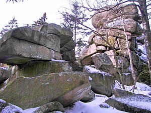
View from the Großer Haberstein to the Kosseine |
||
The Haberstein , consisting of the main summit Großer Haberstein and the secondary summit Kleiner Haberstein 200 meters to the west, is an 847 m high mountain in the Hohen Fichtelgebirge , district of Wunsiedel in Bavaria . It is located in the Bavarian state forest on the Fichtelgebirgs-Höhenweg or Franconian mountain path between Luisenburg and the Kosseine .
The summit area of the heavily forested Großer Haberstein is a huge rock castle made of granite , which is protected as a natural monument (geotope number 479R012).
geology
In the rock formations you can see the mattress-like weathered shape of the Kosseine -Rand granite with clearly horizontal clefts . In contrast to the rock labyrinth of the nearby Luisenburg, the original association of rocks is still preserved. The Haberstein is a protected natural monument with a protection zone of 200 meters around it, which should ensure that stone extraction is excluded. On the uppermost rock there are some trough-like depressions - the vernacular called them "druid bowls". They were created through the weathering of granite and therefore not human-made sacrificial cauldrons for cultic purposes. Next to it there are round holes that were carved into the rock by human hands. They took up the surveying frame, a geodetic facility for national surveying .
history
The name Haberstein first appeared in documents in 1393, when the forest ownership and the boundaries of the then sovereign, the Burgrave of Nuremberg , were described: »[...] the haberstein, which is located on the Hochstein in the Kozzeyn liget [...] ] «. With Kozzeyn the Kösseine is meant. The first link in the word Haberstein is Haber- , an old German word for billy goat. Thus the literal meaning is billy goat stone.
tourism
As early as 1879, wooden stairs led to the highest rock, which were installed by the then Fichtel Mountains section of the German-Austrian Alpine Club . On an engraving in the book by Dr. C. W. Gümbel with the title Geognostic Description of the Fichtelgebirge you can see these stairs. They lead to the northern rock tower called "Pulpit". In 1883 an iron support structure for the joist was installed. The iron construction fulfills its purpose to this day, the wooden parts had to be repeatedly repaired due to the weather. The facility is looked after by the Wunsiedel local group of the Fichtelgebirgsverein .
literature
- Dietmar Herrmann: All about the Kosseine in the Fichtelgebirge , issue 18/2011 of the series of the Fichtelgebirgsverein Das Fichtelgebirge
Web links
Individual evidence
- ↑ Federal Office for Cartography and Geodesy , State Office for Surveying and Geoinformation Bavaria : Digital Topographic Map 1:25 000, Bavaria Atlas , accessed on April 13, 2017


