
Tröstau
| coat of arms | Germany map | |
|---|---|---|

|
Coordinates: 50 ° 1 ' N , 11 ° 57' E |
|
| Basic data | ||
| State : | Bavaria | |
| Administrative region : | Upper Franconia | |
| County : | Wunsiedel in the Fichtel Mountains | |
| Management Community : | Tröstau | |
| Height : | 550 m above sea level NHN | |
| Area : | 19.28 km 2 | |
| Residents: | 2228 (Dec. 31, 2019) | |
| Population density : | 116 inhabitants per km 2 | |
| Postal code : | 95709 | |
| Area code : | 09232 | |
| License plate : | WUN, MAK, REH , SEL | |
| Community key : | 09 4 79 161 | |
| LOCODE : | DE 8TY | |
| Community structure: | 15 districts | |
| Address of the municipal administration: |
Hauptstrasse 6 95709 Tröstau |
|
| Website : | ||
| Mayor : | Rainer Klein ( FW ) | |
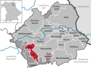
| Location of the municipality of Tröstau in the district of Wunsiedel in the Fichtel Mountains | ||
  |
||

Tröstau is a municipality in the Upper Franconian district of Wunsiedel in the Fichtel Mountains . The state-approved resort in the Fichtelgebirge is located six kilometers southwest of Wunsiedel and is the seat of the Tröstau administrative community .


Community structure
Tröstau consists of a total of 15 districts:
|
The community is centrally located on a high plateau on the south-western edge of the Fichtelgebirge.
history
"Drosen" (Tröstau) was first mentioned in a document on July 20, 1314 . Traut von Hertenberg -Schönbrunn decreed to transfer Schönbrunn Castle , Tröstau and other properties to the Waldsassen monastery after his death , which he later changed to the detriment of the monastery. The municipality keeps the document with the first mention of the place in its archive. Later Heinrich von Hertenberg got into an argument with the burgrave of Nuremberg from the House of Hohenzollern . As a result of the conflict he was forced to cede Schönbrunn Castle and the castle property in Tröstau in 1344. The Hohenzollern already ruled Bayreuth and acquired almost the entire Fichtel Mountains between 1285 and 1415. There is evidence of an iron hammer for the production of wrought iron in 1435 , which was in operation until 1861. In Tröstau there was also mining for tin and iron ore , whereby a hammer gentleman was mentioned in a document in 1437. The place was part of the Hohenzollern principality of Bayreuth , which had become Prussian in 1791 , belonged to the Franconian Empire from 1500 and fell to France with the Peace of Tilsit in 1807 . Tröstau was sold with the Principality of Bayreuth to the Kingdom of Bavaria in 1810 and became an independent political municipality in the course of the administrative reforms in Bavaria in 1818. Granite mining gained in importance around 1900 and at that time employed around 130 workers. In 1954, the district of Fahrenbach of the municipality of Nagel was re- municipalityed to Tröstau, and in 1978 the municipality of Vordorf . In 1978 Tröstau became the seat of the newly created administrative community Tröstau , to which the municipalities of Bad Alexandersbad and Nagel also belong. The community celebrated its 700th anniversary in 2014 with numerous events.
Population development
Between 1988 and 2019 the population decreased from 2,410 to 2,228 by 182 inhabitants.
politics
Municipal council
The 2020 local elections resulted in the following distribution of seats in the local council:
- Free voter association Tröstau: 6 (previously 4)
- CSU : 4 (previously 4)
- SPD : 3 (previously 6)
- Non-attached: 1 (previously 0)
mayor
- Rainer Klein (FW) won the runoff election in the mayoral election.
coat of arms
Blazon : "By the outline of a double mountain ( Kossine ) raised, divided by black and silver, below next to each other two turned away, red armored black bear paws holding a red angle iron and a red hammer." The bear paws are reminiscent of the former rural community of Vordorf (since 1978 a district) in which the last bear in Northern Bavaria was shot in 1769 . The paws also remind of the von Hertenberg family , who were wealthy in the village.
Culture and sights
Buildings
The former, approximately 700-year-old Hammerherrenschloss in the Leupoldsdorf district is a building worth seeing . The archway house belonging to the castle was renovated, the historic gardens from the 19th century were restored. The ponds and facilities surrounding the castle followed as the last construction phase and are used for tourism.
More Attractions
Sights in the area are the Kosseine , from which one has a good view of a large part of the Fichtelgebirge, the rock labyrinth of the Luisenburg near Wunsiedel , the adventure trail through the forest and the forest pool.
Economy and Infrastructure

Tröstau is a tourist destination and has 463 beds. The place is connected to the federal highway 303 / E 48, one of the most important traffic routes in Upper Franconia . A state road leads to Nagel and a district road to Weißenstadt . The Holenbrunn – Leupoldsdorf railway, which was finally closed in 1994 , ran through the town; the route is now partially used for the Bavaria-Bohemia bridge cycle path , which begins in the Tröstau district of Leupoldsdorf at the former train station and leads via Wunsiedel and Selb into Asch in the Czech Republic . As a tourist facility, the place has a forest swimming pool, a glider airfield and an 18-hole golf course.
Public facilities
There is the Evangelical Lutheran Christ Church and the Roman Catholic Church of St. Mary in the village .
As an educational institution, there is the elementary and middle school, the Köseine Schule Tröstau.
Events
Regular events are the annual fire brigade festival, the "Haislfest" of the Fichtelgebirgsverein (FGV) Tröstau, the political Ash Thursday of the SPD, the Kirwa of the boys' club in Leupoldsdorf and the fire brigade in Vordorf, the parish fair, the Kunstkirwa and many other club festivals.
literature
- Johann Kaspar Bundschuh : Tröstau . In: Geographical Statistical-Topographical Lexicon of Franconia . tape 5 : S-U . Verlag der Stettinische Buchhandlung, Ulm 1802, DNB 790364328 , OCLC 833753112 , Sp. 582-583 ( digitized version ).
- Pleikard Joseph Stumpf : Tröstau . In: Bavaria: a geographical-statistical-historical handbook of the kingdom; for the Bavarian people . Second part. Munich 1853, p. 656 ( digitized version ).
Web links
- Web presence of the municipality of Tröstau
- Administrative community Tröstau
- Story of Tröstau by Rudolf Thiem
- Entry on the coat of arms of Tröstau in the database of the House of Bavarian History
Individual evidence
- ↑ "Data 2" sheet, Statistical Report A1200C 202041 Population of the municipalities, districts and administrative districts 1st quarter 2020 (population based on the 2011 census) ( help ).
- ↑ http://www.bayerische-landesbibliothek-online.de/orte/ortssuche_action.html ? Anzeige=voll&modus=automat&tempus=+20111206/194946&attr=OBJ&val= 1312
- ^ The castle and the parish of Schönbrunn near Wunsiedel
- ↑ Tröstau municipal archive
- ↑ by Tröstau by Rudolf Thiem ( page no longer available , search in web archives ) Info: The link was automatically marked as defective. Please check the link according to the instructions and then remove this notice.
- ↑ Bernd Mayer: Little Bayreuth City History p. 75
- ^ Entry on the Tröstau coat of arms in the database of the House of Bavarian History
- ^ Federal Statistical Office (ed.): Historical municipality directory for the Federal Republic of Germany. Name, border and key number changes in municipalities, counties and administrative districts from May 27, 1970 to December 31, 1982 . W. Kohlhammer GmbH, Stuttgart / Mainz 1983, ISBN 3-17-003263-1 , p. 701 .
- ^ Tourism Association Franconia eV

Arzberg | Bad Alexandersbad | Höchstädt in the Fichtel Mountains | Hohenberg an der Eger | Kirchenlamitz | Market people | Marktredwitz | Nail | Röslau | Schirnding | Schönwald | Same | Thiersheim | Thierstein | Tröstau | Weißenstadt | Wunsiedel
Unregulated areas in the district of Wunsiedel in the Fichtelgebirge
Kaiserhammer Forst-Ost |
Martinlamitzer Forst-Süd |
Meierhöfer Page |
Neubauer Forst-Süd |
Tröstauer Forst-Ost |
Tröstauer Forst-West |
Vordorf Forest |
Weißenstadter Forst-Nord |
Weißenstadter Forst-Süd
Fahrbach | Furthammer | Grötschenmühle | Cool green | Leupoldsdorf | Leupoldsdorferhammer | Neuenhammer | Tube mill | Lake house | Silver house | Tröstau | Fourth | Vordorf | Vordorfermühle | Gun hammer