Schirnding
| coat of arms | Germany map | |
|---|---|---|

|
Coordinates: 50 ° 5 ' N , 12 ° 14' E |
|
| Basic data | ||
| State : | Bavaria | |
| Administrative region : | Upper Franconia | |
| County : | Wunsiedel in the Fichtel Mountains | |
| Management Community : | Schirnding | |
| Height : | 459 m above sea level NHN | |
| Area : | 16.52 km 2 | |
| Residents: | 1120 (Dec. 31, 2019) | |
| Population density : | 68 inhabitants per km 2 | |
| Postal code : | 95706 | |
| Area code : | 09233 | |
| License plate : | WUN, MAK, REH , SEL | |
| Community key : | 09 4 79 147 | |
| LOCODE : | DE SII | |
| Market structure: | 8 districts | |
Market administration address : |
Main street 5 95706 Schirnding |
|
| Website : | ||
| Mayoress : | Karin Fleischer ( CSU ) | |
| Location of the Schirnding market in the Wunsiedel district in the Fichtel Mountains | ||
Schirnding is a market in the Upper Franconian district of Wunsiedel in the Fichtel Mountains and the seat of the Schirnding administrative community .
geography
The place is on the northern edge of the cabbage forest in the Fichtel Mountains , near the border with the Czech Republic . The Röslau , a tributary of the Eger, flows through Schirnding .
Community structure
The community is divided into eight districts:
- Dietersgrün
- Fishermen
- Ottenlohe
- Raithenbach
- Schirnding
- Seedorf
- Weidighaus - called Biehaus , former beekeeping for honey extraction for Hohenberg Castle
- Brick hut
history
Until the church is planted
The place Schirnding was first mentioned in a document on October 8, 1377 together with the von Schirnding family . The former office of the Hohenzollern Principality of Bayreuth , which became Prussian in 1791 , fell to France in the Peace of Tilsit in 1807 and became part of the Kingdom of Bavaria in 1810 . In 1818 the political municipality was established.
An important focal point in local history was the so-called Schirndinger Pass as a natural west-east connection, a passage for numerous army and trade routes.
market
On July 29, 1977 the community received the title market .
Incorporations
On April 1, 1977 were part of the municipal reform the districts Dieter Green, fishermen, Ottenlohe Raith Bach, Weidighaus the dissolved municipality Kothigenbibersbach with at that time about 100 residents incorporated. On January 1, 1978, the main town of Fischern was added to the community of the same name, which had about 50 inhabitants at that time. On January 1, 1995, parts of the dissolved community-free area of Arzberger Forst followed .
Population development
Between 1988 and 2018, the population fell from 1,805 to 1,187 by 618 inhabitants or 34.2% - the second highest percentage loss of inhabitants in Bavaria in the period mentioned.
Place Schirnding
| year | 1875 | 1904 | 1950 | 1961 | 1970 | 1987 |
| Residents | 471 | 670 | 2095 | 2493 | 2253 | 1671 |
Church in today's boundaries
| year | 1961 | 1970 | 1987 | 1991 | 1995 | 2005 | 2010 | 2015 | 2016 | 2017 | 2018 |
| Residents | 2678 | 2439 | 1802 | 1804 | 1736 | 1295 | 1192 | 1192 | 1207 | 1184 | 1187 |
politics
Market council
Schirnding's municipal council has twelve members. Seven of them belong to the CSU and five to the SPD (as of the 2020 local elections ).
mayor
Karin Fleischer (CSU) has been the First Mayor of Schirnding since 2014 . She was confirmed in office in the 2020 local elections.
coat of arms
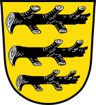
The coat of arms was approved by the Bavarian State Ministry of the Interior on February 19, 1953. Blazon : "In gold, three horizontal, mutilated black branches". The district of Fischern has had its own coat of arms since 1962.
Economy and Infrastructure
traffic
Schirnding is a border station on the Nuremberg – Cheb railway line . Local trains of the Upper Palatinate Railway from Marktredwitz and regional express trains of the Deutsche Bahn from Nuremberg run here , each to Cheb . The border crossing between Schirnding- Pomezí nad Ohří and the Czech Republic is on federal highway 303 / European route 48 . The B 303 runs north of Schirnding.
Production site for porcelain
Christian Paul Aecker is named as the originator of the Schirnding porcelain industry in 1838 with his "Aeckerische porcelain and stoneware factory". In 1901 , Lorenz Reichel , who came from Arzberg , 4.5 kilometers away , opened a porcelain painting workshop and shortly afterwards a white goods factory, from which the Schirnding AG porcelain factory emerged in 1909 . In 1993, the Schirnding AG, the Johann Kronester porcelain factory and the Johann Seltmann Vohenstrauß porcelain factory formed the SKV-Porzellan-Union GmbH, as a result of which in 1997 the white business and parts of the colored business relocated to the Schirnding location. The Arzberg porcelain design was bought in 2000 and produced until the bankruptcy in 2013.
health
The District Office of Wunsiedel (Bavaria) issued exit restrictions on March 19, 2020 for the Neuhaus district in Hohenberg an der Eger and for the Fischern von Markt Schirnding district. This was the second exit restriction in Bavaria to contain the COVID-19 pandemic .
Culture and sights
The Schirnding border museum describes the history of the border between Bavaria and the Czech Republic.
The historic Buchbrunnen is located near the community .
literature
- Harald Stark : The Notthracht family - looking for traces in Egerland, Bavaria and Swabia . Weißenstadt 2006, ISBN 3-926621-46-X
Web links
- Schirnding's website
- Entry on Schirnding's coat of arms in the database of the House of Bavarian History
Individual evidence
- ↑ "Data 2" sheet, Statistical Report A1200C 202041 Population of the municipalities, districts and administrative districts 1st quarter 2020 (population based on the 2011 census) ( help ).
- ↑ http://www.schirnding.info/?page_id=99
- ↑ https://www.karin-fleischer.de/
- ↑ Bavarian State Library Online
- ↑ a b Chronicle of the Frontier
- ↑ a b Federal Statistical Office (ed.): Historical municipality register for the Federal Republic of Germany. Name, border and key number changes in municipalities, counties and administrative districts from May 27, 1970 to December 31, 1982 . W. Kohlhammer GmbH, Stuttgart / Mainz 1983, ISBN 3-17-003263-1 , p. 700 and 701 .
- ↑ Frankenpost : Nothing changes in the extremely narrow election result in Schirnding. March 18, 2014, accessed August 6, 2020 .
- ^ City of Hohenberg ad Eger: Mayor election VG Schirnding. March 15, 2020, accessed August 6, 2020 .
- ↑ http://www.porzellanstrasse.de/de/porzellanstrasse/orte/schirnding.html
- ↑ District Office Wunsiedel: Sonderamtsblatt 07-2020 from March 19, 2020 (PDF) Retrieved on March 22, 2020 .
- ^ Frankenpost : curfews imposed on two municipalities in the Wunsiedel district. Retrieved March 22, 2020 .


