Ruheberg (Fichtel Mountains)
| Calm mountain | ||
|---|---|---|
|
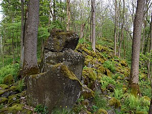
Basalt blocks on the Ruheberg |
||
| height | 693 m | |
| location | Bavaria | |
| Mountains | Fichtel Mountains | |
| Coordinates | 50 ° 0 '14 " N , 12 ° 10' 48" E | |
|
|
||
| rock | basalt | |
The Ruheberg or Ruhberg (693 m above sea level ) is a densely forested basalt cone east of Haingrün and belongs to the Reichsforst in the Fichtelgebirge . The summit region is designated as a nature reserve, the summit itself forms a 200 m long mountain ridge and is overgrown with ash trees , maples and beech trees.
geography
Together with the Preisberg (635 m) about one kilometer to the northeast , the Ruheberg is affected in the east and south by the district roads WUN 11 and TIR 14 , which connect Konnersreuth with Pechbrunn . Preisdorf is located at the eastern foot of the mountain .
geology
A large basalt eruption area lies between Marktredwitz , Mitterteich , Konnersreuth and Seußen . It is the westernmost branch of the North Bohemian basalt volcanism. In the Miocene there, liquid basalt mass rose through the granite .
Origin of name
Millions of years ago, an active volcano , the Ruhe- or Ruhberg has been resting since then. It is now a dormant volcano .
literature
- Dietmar Herrmann, Helmut Süssmann: Fichtel Mountains, Bavarian Vogtland, Steinwald, Bayreuther Land. Lexicon . Ackermannverlag, Hof (Saale) 2000, ISBN 3-929364-18-2 .
- Gorny Martina / Herrmann Dietmar: The Ruhberg in the Fichtelgebirge, in: SIEBENSTERN Issue 3-2018, pp. 12-13
cards
- Bavarian State Surveying Office: UK 50-13 Fichtelgebirge / Steinwald Nature Park, eastern part, scale 1: 50,000


