
Konnersreuth
| coat of arms | Germany map | |
|---|---|---|

|
Coordinates: 50 ° 1 ' N , 12 ° 14' E |
|
| Basic data | ||
| State : | Bavaria | |
| Administrative region : | Upper Palatinate | |
| County : | Tirschenreuth | |
| Height : | 573 m above sea level NHN | |
| Area : | 23.48 km 2 | |
| Residents: | 1729 (Dec. 31, 2019) | |
| Population density : | 74 inhabitants per km 2 | |
| Postal code : | 95692 | |
| Area code : | 09632 | |
| License plate : | TIR, KEM | |
| Community key : | 09 3 77 131 | |
| Market structure: | 17 districts | |
Market administration address : |
Hauptstrasse 17 95692 Konnersreuth |
|
| Website : | ||
| Mayor : | Max Bindl ( FW ) | |
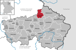
| Location of the Konnersreuth market in the Tirschenreuth district | ||
  |
||

Konnersreuth (Bavarian: Kannaschrad) is a market in the Upper Palatinate district of Tirschenreuth .
geography
Geographical location
Konnersreuth is located in the Upper Palatinate North planning region on the northeastern foothills of the Stone Forest between the Fichtel Mountains and the Upper Palatinate Forest near the border with the Czech Republic and the border crossing to the town of Cheb (Eger) in western Bohemia .
For planning region Upper Palatinate North includes the districts : Kondrau , Konnersreuth, Pechbrunn and Pleußen and the places Fockenfeld, Gropp home, Höflas, Green, Neudorf and Rosenbühl.
Community structure
There are 17 districts:
|
history
Until the church is planted
Konnersreuth was mentioned for the first time in 1218 in a document from the Waldsassen monastery , belonged to the extensive manor of the nearby monastery and shared its historical fate with devastation and change of faith. In 1468 Konnersreuth received market rights and the Fockenfeld estate, the later Fockenfeld monastery was the seat of a blood judiciary and a lower court of the Waldsassen monastery. In 1556 the Fockenfeld estate was secularized by the Elector Ottheinrich von Wittelsbach, who had accepted the Evangelical Lutheran creed, and came into private ownership. The taxable residents of the municipality of Konnersreuth can be seen in a Turkish tax account book of the Reichstürkenhilfe from 1567 ( State Archives Amberg ).
For generations, the Sölch family (Salich, Solich, Seelch, etc.) had considerable property in Konnersreuth, on the Liebertsmühl near Konnersreuth (Helene Bruscha, Annelies Sölch: Sölch family from Zettendorf, Eger district in Böhmen , February 1993, page 24 ff A copy of the typewritten manuscript in the Vienna City and State Archives , Municipal Department 8, Head of Service) and resident at the Fockenfeld estate until 1647. As a result of administrative reforms in the Kingdom of Bavaria before 1818, today's municipality of Konnersreuth was created.
Therese Neumann
Konnersreuth became known through the allegedly stigmatized Therese Neumann ("Resl von Konnersreuth"), daughter of a tailor in Konnersreuth and a farmer's maid. Before her death in 1962, the Fockenfeld estate near Konnersreuth with the Fockenfeld castle, which was expanded around 1750, was bought by the Bahner family of manufacturers from Oberlungwitz in Saxony and the Fockenfeld monastery was founded in the building complex on her initiative and with donations that were intended for her . The Theresianum monastery in Konnersreuth was founded after Therese Neumann's death, also financed by donations.
Incorporations
On January 1, 1972, a sub-area of the dissolved community of Kondrau with the places Brandmühle , Dollermühle , Dornhof , Geierhut , Grün , Grünmühle , Höflas , Lippertsmühle , Neubau , Neuhof and Siegelmühle was incorporated. On July 1, 1972, a part of Pleuss was added.
Population development
- approx. 1780: 954 inhabitants
- 1961: 1923 inhabitants
- 1970: 2031 inhabitants
- 1987: 1825 inhabitants
- 1991: 1857 inhabitants
- 1995: 1944 inhabitants
- 2000: 2012 inhabitants
- 2005: 1974 inhabitants
- 2010: 1900 inhabitants
- 2015: 1805 inhabitants
Between 1988 and 2018 the population decreased by 54 or 3% from 1809 to 1755.
politics
Mayor and town council
Max Bindl (FW) has been mayor since the 2008 local elections.
The municipal council has 15 members:
- CSU 5 seats
- Free voters 5 seats
- SPD 2 seat
- One local spokesman each for Rosenbühl and Höflas
coat of arms
Blazon: "In silver on green ground, side by side, three green fir trees, in front of which a red deer is jumping."
The coat of arms has been known since 1468 and was renewed in 1978.
Culture and sights
Architectural monuments
Buildings
- Birthplace of Therese Neumann , formerly a modest single house with a workshop of the Neumann family and her grave in the cemetery in Konnersreuth
- Late baroque parish church of St. Laurentius with an onion dome
- Fockenfeld Castle in the Fockenfeld Monastery
Soil monuments
See: List of ground monuments in Konnersreuth
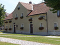
Birthplace of Therese Neumann
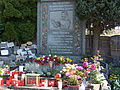
Grave of Therese Neumann

Theresianum Monastery

View of Konnersreuth


Economy and Infrastructure
In 1998, Konnersreuth had no employees subject to social security contributions in agriculture, forestry, trade and transport. 637 employees subject to social insurance were registered in production. Nine companies were active in the manufacturing industry and four companies in the construction industry. In addition, in 1999 there were 51 farms with an agricultural area of 1395 hectares. Of this, 982 hectares were arable land and 413 hectares were permanent green space.
education
The following institutions exist (as of 1999):
- 75 kindergarten places with 79 children in Konnersreuth
- a primary and secondary school (elementary school) for boys and girls with nine teachers and 162 students in Konnersreuth
- a state secondary school for boys and girls in Waldsassen
- a state secondary school for boys in Waldsassen
- a Catholic private secondary school for girls in the Waldsassen monastery
- a Catholic private high school for boys in the Fockenfeld Monastery with eight teachers and 58 students
Personalities
Sons and daughters of the place
- Liberate White (1675-1716), beatified Father, Franciscan (OFM) , who was stoned on March 3, 1716 near Gondar ( Ethiopia )
- Therese Neumann (1898–1962), called Resl von Konnersreuth , daughter of a tailor in Konnersreuth and a farmer's maid, famous for her stigmatization , which is said to have occurred since 1925 and which led to a rush of visitors in Konnersreuth.
- Ferdinand Neumann (1911–1999), Bavarian politician and brother of Therese Neumann , called "Resl von Konnersreuth"
Personalities associated with the place
- Josef Naber (1870–1967), Catholic pastor in Konnersreuth during Therese Neumann's lifetime
- Alois Grillmeier SJ (1910–1998), Roman Catholic theologian and cardinal deacon
- Josef Hanauer (1913–2003), Catholic pastor in Regensburg and journalist
- Otmar Seidl (* 1944), reviewer in the case of Therese Neumann , internist, psychoanalyst and sociologist
- Dietmar Hamann (* 1973), soccer player, grew up in Konnersreuth
literature
- Heribert Sturm : Konnersreuth 500 years of Markt , Waldsassen 1971
- Lena Panzer: Konnersreuth and its places of worship. On the topography of a cult in the present . Thesis in the subjects of Folklore / Ethnology, Jena 2009, online
Web links
- Aerial photos of the place
- Entry on the Konnersreuth coat of arms in the database of the House of Bavarian History
Individual evidence
- ↑ "Data 2" sheet, Statistical Report A1200C 202041 Population of the municipalities, districts and administrative districts 1st quarter 2020 (population based on the 2011 census) ( help ).
- ^ Konnersreuth, M. Bayerische Bibliothek Online, accessed on June 15, 2014 .
- ^ Lineage Sölch from Zettendorf, Eger district in Bohemia , German Gender Book Volume 214 (58th General Volume), 2002, CA Starke Verlag Limburg an der Lahn, ISBN 3-7980-0214-2 , there: pages 1023 to 1026; Zettendorf is today's Cetnov , a district of Cheb
- ↑ Bavarian State Office for Statistics and Data Processing (Hrsg.): The municipalities of Bavaria according to the territorial status May 25, 1987. The population of the municipalities of Bavaria and the changes in the acquisitions and territory from 1840 to 1987 (= contributions to Statistics Bavaria . Issue 451). Munich 1991, p. 85–86 , urn : nbn: de: bvb: 12-bsb00070717-7 ( digitized version - Notes 9 and 23).
- ^ Wilhelm Volkert (ed.): Handbook of Bavarian offices, communities and courts 1799–1980 . CH Beck, Munich 1983, ISBN 3-406-09669-7 , p. 580 .
- ↑ Communication from the municipal administration

Bad Neualbenreuth | Bärnau | Fire | Ebnath | Erbendorf | Falkenberg | Friedenfels | Fuchsmühl | Immenreuth | Kastl | Kemnath | Konnersreuth | Krummennaab | Kulmain | Leonberg | Mähring | Mitterteich | Neusorg | Pechbrunn | Plößberg | Pullenreuth | Reuth near Erbendorf | Tirschenreuth | Waldershof | Waldsassen | Wiesau