
Kulmain
| coat of arms | Germany map | |
|---|---|---|

|
Coordinates: 49 ° 53 ' N , 11 ° 54' E |
|
| Basic data | ||
| State : | Bavaria | |
| Administrative region : | Upper Palatinate | |
| County : | Tirschenreuth | |
| Height : | 485 m above sea level NHN | |
| Area : | 35.55 km 2 | |
| Residents: | 2241 (Dec. 31, 2019) | |
| Population density : | 63 inhabitants per km 2 | |
| Postal code : | 95508 | |
| Area code : | 09642 | |
| License plate : | TIR, KEM | |
| Community key : | 09 3 77 133 | |
| Community structure: | 19 districts | |
| Address of the municipal administration: |
Main street 28 95508 Kulmain |
|
| Website : | ||
| Mayor : | Günter Kopp ( CSU ) | |
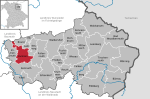
| Location of the municipality of Kulmain in the Tirschenreuth district | ||
  |
||

Kulmain (Bavarian: Kulma) is a municipality in the Upper Palatinate district of Tirschenreuth and lies between the Steinwald and the Fichtelgebirge .
geography
Kulmain borders on Kemnath , Immenreuth , Brand , Ebnath , Neusorg and Pullenreuth .
Community structure
Kulmain has 19 districts:
history
Place name
The place name Kulmain comes from the Slavic Cholmina or Chomane and means hill dwellers.
Modern times
Kulmain belonged to the Amberg Rent Office and the Waldeck Regional Court of the Electorate of Bavaria . In Kulmain there were two country estates with a jurisdiction as with open court brands : Kulmain at the church of the barons of Gobel and Kulmain at the pond of the barons of Ponzelin. In the course of the administrative reforms in Bavaria , today's political municipality was created with the municipal edict of 1818 .
Incorporations
In 1945 or 1946 the previously independent municipality of Oberbruck was incorporated. On January 1, 1972, Zinst was added. On January 1, 1978 areas of the dissolved communities Lenau and Oberwappenöst followed. On January 1, 2017, parts of the dissolved community-free area Lenauer Forst came to the community.
Population development
Between 1988 and 2018, the population increased from 2,154 to 2,278 by 124 or 5.8%.
politics
Municipal council
The municipal council consists of 14 members:
- CSU 6 seats
- Free voters Kulmain 3 seats
- SPD 2 seats
- Citizens' list 3 seats
coat of arms
The description of the coat of arms reads: "Under the blue head of the shield, in it three silver tips covered with a black bar, in red a three-part silver round church building (Armesberg)."
The municipality has had the coat of arms since 1976.
Town twinning
A partnership has existed with the city of Purbach am Neusiedler See since 1988 .
Culture and sights
Architectural monuments
- The former school building at Hauptstrasse 12 in Kulmain is marked with the year 1841. The building with a flat hipped roof and stone walls is registered under the number D-3-77-133-2 as a listed building of the Bavarian State Office for Monument Preservation .
- Kulmain Castle
- Kulmain Castle at the church
Natural monuments
The place name provides a reference to the Kulmen , which rise not far from the community (compare Rauher Kulm ). The Armesberg is not far from the village .
Personalities
Honorary citizen
- Martin Wiesend (1910–2003), Auxiliary Bishop of the Archdiocese of Bamberg
- Gerd Schönfelder (* 1970), multiple Paralympic winner
Sons and daughters of the church
- Georg Engelhard von Löhneysen (1552–1622), mining captain, author and publisher
- Nathanael Burger OFM (1733–1780), Franciscan, China missionary, Apostolic Vicar and Bishop in China
- Martin Vogt (1781–1854), concert organist, cellist and composer
- Martin Wiesend (1910–2003), auxiliary bishop in Bamberg and titular bishop of Migirpa
- Hanna-Barbara Gerl-Falkovitz (* 1945 in Oberwappenöst), religious philosopher, professor at the TU Dresden
- Wolfgang Lippert (* 1955 in Frankenreuth), local politician and district administrator of the Tirschenreuth district
- Gerd Schönfelder (* 1970), multiple Paralympic winner
Individual evidence
- ↑ "Data 2" sheet, Statistical Report A1200C 202041 Population of the municipalities, districts and administrative districts 1st quarter 2020 (population based on the 2011 census) ( help ).
- ↑ http://www.bayerische-landesbibliothek-online.de/orte/ortssuche_action.html ? Anzeige=voll&modus=automat&tempus=+20111108/094819&attr=OBJ&val= 1087
- ↑ Ulrich children: The fortifications in the Tirschenreuth district . From the series: Works on the Archeology of Southern Germany, Volume 28 . Publishing house Dr. Faustus, Büchenbach 2013, ISBN 978-3-933474-82-7 , p. 56.
- ^ Wilhelm Volkert (ed.): Handbook of Bavarian offices, communities and courts 1799–1980 . CH Beck, Munich 1983, ISBN 3-406-09669-7 , p. 495 .
- ^ Federal Statistical Office (ed.): Historical municipality directory for the Federal Republic of Germany. Name, border and key number changes in municipalities, counties and administrative districts from May 27, 1970 to December 31, 1982 . W. Kohlhammer GmbH, Stuttgart / Mainz 1983, ISBN 3-17-003263-1 , p. 663 .
- ↑ Biggest piece of the pie , www.onetz.de of April 10, 2014
- ↑ List of monuments for Kulmain (PDF) at the Bavarian State Office for Monument Preservation
Web links
- Entry on the coat of arms of Kulmain in the database of the House of Bavarian History
- Kulmain: Official statistics of the LfStat (PDF; 1.24 MB)
- Aerial photos of the community

Bad Neualbenreuth | Bärnau | Fire | Ebnath | Erbendorf | Falkenberg | Friedenfels | Fuchsmühl | Immenreuth | Kastl | Kemnath | Konnersreuth | Krummennaab | Kulmain | Leonberg | Mähring | Mitterteich | Neusorg | Pechbrunn | Plößberg | Pullenreuth | Reuth near Erbendorf | Tirschenreuth | Waldershof | Waldsassen | Wiesau