Reuth near Erbendorf
| coat of arms | Germany map | |
|---|---|---|

|
Coordinates: 49 ° 51 ' N , 12 ° 7' E |
|
| Basic data | ||
| State : | Bavaria | |
| Administrative region : | Upper Palatinate | |
| County : | Tirschenreuth | |
| Management Community : | Krummennaab | |
| Height : | 476 m above sea level NHN | |
| Area : | 16.91 km 2 | |
| Residents: | 1118 (Dec. 31, 2019) | |
| Population density : | 66 inhabitants per km 2 | |
| Postal code : | 92717 | |
| Primaries : | 09681, 09682, 09683 | |
| License plate : | TIR, KEM | |
| Community key : | 09 3 77 149 | |
| Community structure: | 15 districts | |
| Address of the municipal administration: |
Kirchplatz 1 92717 Reuth near Erbendorf |
|
| Website : | ||
| Mayor : | Werner Prucker (FW) | |
| Location of the municipality of Reuth near Erbendorf in the Tirschenreuth district | ||
Reuth bei Erbendorf (officially: Reuth b.Erbendorf) is a municipality in the Upper Palatinate district of Tirschenreuth and a member of the Krummennaab administrative community .
geography
Geographical location
Reuth bei Erbendorf is located between Steinwald and the Waldnaabtal nature reserve .
Community structure
The community of Reuth near Erbendorf is divided into 15 districts:
|
history
Until the 19th century
The aristocratic family of the Trautenbergs owned Reuth Castle and the Reuth manor from 1337 to 1601 . The property passed to Georg Friedrich von Unruh through marriage in 1602 and passed to the related Sparnecker family.
In the time of the family of Sparneck in Reuth (1628-1744), the founding of fell Schloßbrauerei Reuth 1742. From the tradition of brewing right in the form of a brewery was built in 1742, a commercial operation. The barons of Reitzenstein bought the Hofmark Reuth in 1772 and exercised the manorial rule and jurisdiction until 1848 .
On August 15, 1864, Reuth received a train station. The railway line initially led from Weiden to Eger .
Concentration camp subcamps
From January 12, 1945 to April 22, 1945, shortly before the end of World War II , there was a satellite camp of the Flossenbürg concentration camp in the village . The prisoners did forced labor for the Paul Röthgen bakery, which supplied the Flossenbürg concentration camp with bread. The prisoners were five Germans and two Dutch, all of whom were Jehovah's Witnesses . They were housed under the roof of the bakery and were guarded by an older SS man .
Incorporations
In 1945 or 1946 part of the previously independent community of Trautenberg was incorporated. On January 1, 1972, Röthenbach am Steinwald was added.
Population development
Between 1988 and 2018, the population fell from 1179 to 1137 by 42 or 3.6%.
politics
The municipal council has 13 members:
(Status: local election on March 15, 2020)
coat of arms
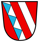
Blazon: Two silver diagonal bars in red, the front of which is covered with three blue tips.
The municipality has had the coat of arms since 1982.
Culture and sights
- Reuth Castle with the castle brewery
- Castle walls (Escheldorf) , abandoned castle in Escheldorf
- Catholic Church of St. Catherine
- Catholic church "Maria Hilf" in the Premenreuth district.
Economy and Infrastructure
traffic
- The Falkenberg junction of the A 93 Regensburg - Hof can be reached after about five kilometers from Reuth via the B 299 .
- Reuth has a train station on the Weiden – Oberkotzau railway line .
- From 1894 to 1958, Reuth was the starting point of a narrow-gauge industrial railway , the Reuth – Friedenfels railway , and from 1909 to 1997 a standard-gauge branch line to Erbendorf .
Established businesses
literature
- Peter Braun: The Lords of Sparneck - family tree, distribution, brief inventory. In: Archive volume for the history of Upper Franconia. Bayreuth 2002.
- Adalbert Busl : The removal of the Bohemian state emblems in 1801. In: Wir am Steinwald 11, 2003. P. 56–60.
- Harald Fähnrich: Pleasure garden and play garden of the Reuth rule. In: HEIMAT - Landkreis Tirschenreuth 12, 2000. "Zunftring, Graf und Judenstein", contributions to the history of our homeland between the Fichtelgebirge and the Bohemian Forest , pp. 50–62.
- Michael Schaudig: 250 years of Reuth Castle Brewery 1742–1992. Reuth 1992.
- Andreas Schwohnke: Between Wittelsbach and Habsburg: Reuth near Erbendorf, a Bohemian fiefdom in the Upper Palatinate. In: HEIMAT - Landkreis Tirschenreuth 19, 2007. "Burgstall, Schlacht und Howernessl", contributions to the history of our homeland between the Fichtel Mountains and the Bohemian Forest, pp. 136–159.
Web links
- Aerial photos of the place
- Entry on the coat of arms of Reuth near Erbendorf in the database of the House of Bavarian History
Individual evidence
- ↑ "Data 2" sheet, Statistical Report A1200C 202041 Population of the municipalities, districts and administrative districts 1st quarter 2020 (population based on the 2011 census) ( help ).
- ↑ http://www.bayerische-landesbibliothek-online.de/orte/ortssuche_action.html ? Anzeige=voll&modus=automat&tempus=+20111108/161732&attr=OBJ&val= 1096
- ↑ a b Reuth (b Erbendorf) at bahnrelektiven.net, accessed on July 7, 2016
- ^ Website of the Flossenbürg Concentration Camp Memorial Accessed July 6, 2016
- ↑ Wolfgang Benz , Barbara Distel (Ed.): Flossenbürg. The Flossenbürg concentration camp and its satellite camps . C. H. Beck, Munich 2007, ISBN 978-3-406-56229-7 , pp. 240 .
- ^ Wilhelm Volkert (ed.): Handbook of Bavarian offices, communities and courts 1799–1980 . CH Beck, Munich 1983, ISBN 3-406-09669-7 , p. 537 .


