
Leonberg (Upper Palatinate)
| coat of arms | Germany map | |
|---|---|---|

|
Coordinates: 49 ° 57 ' N , 12 ° 17' E |
|
| Basic data | ||
| State : | Bavaria | |
| Administrative region : | Upper Palatinate | |
| County : | Tirschenreuth | |
| Management Community : | Mitterteich | |
| Height : | 548 m above sea level NHN | |
| Area : | 51.33 km 2 | |
| Residents: | 1022 (Dec. 31, 2019) | |
| Population density : | 20 inhabitants per km 2 | |
| Postal code : | 95666 | |
| Area code : | 09633 | |
| License plate : | TIR, KEM | |
| Community key : | 09 3 77 137 | |
| Community structure: | 20 districts | |
| Association administration address: | Kirchplatz 12 95666 Mitterteich |
|
| Website : | ||
| Mayor : | Johann Burger | |
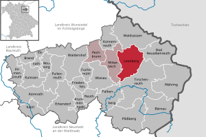
| Location of the community of Leonberg in the Tirschenreuth district | ||
  |
||

Leonberg is a municipality in the Upper Palatinate district of Tirschenreuth and has been a member of the Mitterteich administrative community since 1974 .
geography
The community is located between the towns of Mitterteich , Waldsassen and Tirschenreuth . From the village, which is situated on a slope, there is a broad view over the Wondrebsenke .

Community structure
Leonberg has 20 districts:
|
history
Leonberg in its current form was created on April 1st, 1971 through the voluntary amalgamation of the previously independent communities of Leonberg, Großensees and Pfaffenreuth. Leonberg and Großensees were traditionally characterized by agriculture, while the economic focus in Pfaffenreuth was the Bayerland mine . Pebbles were extracted there until the early 1970s .
Population development
Between 1988 and 2018, the population fell from 1,047 to 1,019 by 28 or 2.7%.
coat of arms
The municipality of Leonberg has had its own coat of arms since 1980.
Official, heraldic description of the coat of arms
"In silver a growing red dragon with a black hammer in its claws, covered with a lowered blue wavy bar."
Meaning of the coat of arms
The red dragon is the heraldic animal of the Waldsassen monastery . It indicates the relationship between the community and the monastery, which dates back to 1243. The hammer symbolizes mining, mainly operated in Pfaffenreuth, and the blue bar for the river Wondreb , which flows through the municipality.

Culture and sights
Buildings
The baroque parish church of St. Leonhard is worth seeing in the village , as is the All Saints Church in the parish of Wernersreuth .
Protected areas
The nature reserve Wondrebaue southeast of Leonberg. The iron hat natural monument is a reminder of the mining industry in Pfaffenreuth. It is near the disused colliery.
traffic
The community of Leonberg can be reached via the federal roads 15 and 299 , as well as the A 93 (Mitterteich-Nord and -Süd exits).
Individual evidence
- ↑ "Data 2" sheet, Statistical Report A1200C 202041 Population of the municipalities, districts and administrative districts 1st quarter 2020 (population based on the 2011 census) ( help ).
- ↑ http://www.bayerische-landesbibliothek-online.de/orte/ortssuche_action.html ? Anzeige=voll&modus=automat&tempus=+20111108/135444&attr=OBJ&val= 1088
- ^ Wilhelm Volkert (ed.): Handbook of Bavarian offices, communities and courts 1799–1980 . CH Beck, Munich 1983, ISBN 3-406-09669-7 , p. 580 .
Web links
- Entry on the coat of arms of Leonberg (Upper Palatinate) in the database of the House of Bavarian History

Bad Neualbenreuth | Bärnau | Fire | Ebnath | Erbendorf | Falkenberg | Friedenfels | Fuchsmühl | Immenreuth | Kastl | Kemnath | Konnersreuth | Krummennaab | Kulmain | Leonberg | Mähring | Mitterteich | Neusorg | Pechbrunn | Plößberg | Pullenreuth | Reuth near Erbendorf | Tirschenreuth | Waldershof | Waldsassen | Wiesau