
Wippra dam
| Wippra reservoir / Wippertalsperre (Wippra reservoir / Wipper reservoir ) |
|||||||||
|---|---|---|---|---|---|---|---|---|---|
 |
|||||||||
|
|||||||||
|
|||||||||
| Coordinates | 51 ° 34 '0 " N , 11 ° 12' 22" E | ||||||||
| Data on the structure | |||||||||
| Construction time: | 1951-1952 | ||||||||
| Height above valley floor: | 18 m / 17.9 m | ||||||||
| Height above foundation level : | 24.9 m | ||||||||
| Building volume: | 19,000 m³ | ||||||||
| Crown length: | 126 m | ||||||||
| Crown width: | 6 m | ||||||||
| Base width: | 18 m | ||||||||
| Power plant output: | 22 kW | ||||||||
| Data on the reservoir | |||||||||
| Altitude (at congestion destination ) | 292.6 m above sea level NN | ||||||||
| Water surface | 32 ha (0.32 km²) | ||||||||
| Reservoir length | 2.2 km | ||||||||
| Reservoir width | 190 m | ||||||||
| Storage space | 2 million m³ | ||||||||


The Wippra dam , also called Wippertalsperre and partly also called Vorsperre Wippra or Vorsperre Wipper , in the Harz is a dam , built from 1951 to 1952 and consisting of a dam , reservoir and hydroelectric power station , on the Wipper near Wippra in the Mansfeld-Südharz district in Saxony-Anhalt .
The operator is the Saxony-Anhalt dam company, which maintains a total of 31 dams. The dam is used to increase low water levels , flood protection , fishing , local recreation and electricity generation .
Geographical location
The Wippra dam is located in the Lower Harz immediately east of the Harz / Saxony-Anhalt nature reserve . Near Mansfeld , it extends around 5 km west-southwest of the Sangerhausen district of Wippra on the Saale - Wipper tributary .
Dam wall
The weight of the straight concrete gravity dam dams the luffers. It is about 126 m long, 18 m (according to other information 17.9 m) high and 6 m at its crown and around 18 m wide at the base. It is 24.9 m high above the foundation level. The joint was sealed with copper sheet. The wall is provided with a free crown overflow to relieve the flood
Reservoir
The reservoir is about 32 ha (0.32 km²) in size. It extends approximately in a west-east direction to around 2.2 km in length and is around 190 m wide in the middle. It has around 2 million m³ of storage space. Its water surface is 292.6 m above sea level. NN .
Hydroelectric power plant
With the hydropower plant integrated into the dam , electricity is generated from hydropower . The installed power is 22 kW . A 17 m long steel pipe DN 600 (circular profile), which is equipped with inspection slide gates (1.3 mx 1.1 m), a butterfly valve DN 600 (circular profile), a ring piston valve DN 600 (circular profile), a bypass pipe DN 300 serves as the bottom outlet (Circular profile) is equipped with 2 wedge gate valves and a Francis turbine for self-supply. The bottom discharge capacity reaches up to 3 m³ / s with full back-up.
history
For centuries, which was Mansfeld by the copper slate - mining and smelting the recovered from ore coined. In general, water and mining are opposed to each other, because water is the miner's "enemy". On the other hand, the water is needed to extract ores. That was the reason why dams (artificial waters) were created in many areas of the Harz Mountains , which still characterize the landscape today.
This is also the case with the Wippra dam, which was actually planned as a pre- dam . Its dam was built from February 1951 to November 1952 to secure the service water supply for the copper processing plants in Mansfeld and Hettstedt; the constant water supply of the VEB Mansfeld-Kombinat " Wilhelm Pieck " should be secured. The original plan was to build a (larger) main barrier , the barrier structure of which was to be erected between today's reservoir and Wippra near the western end of the village. But that never happened; The reasons for this are certainly the low water consumption for smelting. The function of the dam for flood protection is rather limited as a pre- dam .
Tourism and hiking
The Wippra dam is a popular destination and guided tours through the inside of the dam are offered. The dam is included as No. 219 in the system of stamping points of the Harz hiking pin; the stamp box ( ⊙ ) is located at the vantage point on about half of the circular hiking trail, on the right. An approximately 5.8 km long circular hiking trail leads around the reservoir, and since 2009 there has been the Harzer Naturistenstieg , the first official nude hiking trail in Germany, south to southwest of the reservoir .
gallery

Wippra dam

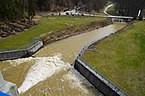
Wippra dam from below

Wippra dam from above
procedure

.jpg)

.jpg)
Individual evidence
- ↑ a b c d e f g Wippra dam ( Memento from February 12, 2013 in the web archive archive.today ), at the Saxony-Anhalt dam operation, from talsperren-lsa.de
- ↑ a b c d The Wippra dam , on harzlife.de
- ↑ a b c d e f Wippra dam (and other dams), in the southern area , on talsperren-lsa.de
- ↑ a b Saxony-Anhalt viewer of the State Office for Surveying and Geoinformation ( notes )
- ↑ a b c d Map services of the Federal Agency for Nature Conservation ( information )
- ↑ Guided tours: Wippra dam ( memento from February 12, 2013 in the web archive archive.today ), from talsperren-lsa.de
- ↑ Harz hiking pin: stamp 219 / Wippertalsperre , on harzer-wandernadel.de
- ↑ Nudist hiking trail in the Harz Mountains , on Kreiszeitung.de
See also
Web links
- Wippra dam (and other dams), in the southern dam area , on talsperren-lsa.de