Stará Voda u Mariánských Lázní
| Stará Voda | ||||
|---|---|---|---|---|
|
||||
| Basic data | ||||
| State : |
|
|||
| Region : | Karlovarský kraj | |||
| District : | Cheb | |||
| Area : | 5401.2526 ha | |||
| Geographic location : | 49 ° 59 ' N , 12 ° 37' E | |||
| Height: | 605 m nm | |||
| Residents : | 487 (Jan. 1, 2019) | |||
| Postal code : | 353 01 - 354 93 | |||
| License plate : | K (old CH) | |||
| structure | ||||
| Status: | local community | |||
| Districts: | 3 | |||
| administration | ||||
| Mayor : | Eva Procházková (Status: 2018) | |||
| Address: | Stará Voda 146 353 01 Mariánské Lázně 1 |
|||
| Municipality number: | 539112 | |||
| Website : | www.staravoda.cz | |||
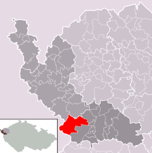
| Location of Stará Voda in the Cheb district | ||||

|
||||
Stará Voda (German Altwasser ) is a municipality in Karlovarský kraj in the Czech Republic . It is located on the edge of the Český les Nature Park two kilometers southwest of the town of Lázně Kynžvart and belongs to the Okres Cheb .
geography
Geographical location
The place is located at 605 m above sea level. M. in a moor area of the Tachau basin ( Tachovská brázda ) between the Upper Palatinate Forest and the Kaiserwald on the upper reaches of the Bahnitý potok ( Kothüllbach ).
Neighboring communities
Neighboring towns are Lázně Kynžvart in the east, Sekerské Chalupy and Jedlová in the south, Vysoká in the west and Horní Žandov and Dolní Žandov in the north. The Chebský vršek rises to the west ( Egerbühl , 680 m)
Community structure
The municipality Stará Voda consists of the districts Sekerské Chalupy ( Hack houses ) Stará Voda ( backwaters ) and Vysoká ( Maier Green ). Basic settlement units are Háj ( Grafengrün ), Jedlová ( Tannaweg ), Nové Mohelno ( Neumugl ), Sekerské Chalupy, Slatina ( Lohhäuser ), Stará Voda, U nádraží and Vysoká. The village of Pozorka ( Gibacht ) also belongs to Stará Voda .
history
The village of Altwasser was first mentioned in a document in 1380. In the Berní rula from 1654 33 farmers, 4 cottagers and 5 gardeners are named for the place. From the middle of the 19th century, Altwasser formed a municipality in the judicial district of Bad Königswart .
In 1868 the construction of the Kaiser-Franz-Josephs-Bahn from Vienna to Eger began . With the start of traffic in 1872, the Bad Königswart train station was inaugurated , which was built east of the village on the corridors of Altwasser. In 1880, 1135 people lived in Altwasser, in 1930 there were 1112.
After the Munich Agreement , the place was added to the German Empire and belonged to the Marienbad district until 1945 .
After the Germans were driven out, Stará Voda only had 368 inhabitants in 1950. Between 1956 and 1957 the historic plant of the Tannaweg lead smelter ( Tavírna olova ) in Jedlová was blown up in the course of the clearing of the border area.
The municipality is divided into the cadastral districts of Háj u Staré Vody, Jedlová u Staré Vody, Nové Mohelno, Slatina u Staré Vody, Stará Voda u Mariánských Lázní and Vysoká u Staré Vody. The area extends to the Bavarian border and includes a large forest area around the mountains Dyleň ( Tille Berg , 939 m), Čupřina ( Schopf Berg , 865 m) and Tišina ( the rest , 792 m), the source of the hammer stream , Muglbaches and Amsel stream is . This is where the desolation of the border settlements of Slatina and Nové Mohelno, demolished during the Cold War, lie.
Culture and sights
- St. Anna Chapel, a baroque building from 1712
- Niche chapel on the road to Cheb, is in a state of complete disrepair
- Mineral spring at the Amselbach near Jedlová ( Tannaweg )
Individual evidence
- ↑ http://www.uir.cz/obec/539112/Stara-Voda
- ↑ Český statistický úřad - The population of the Czech municipalities as of January 1, 2019 (PDF; 7.4 MiB)
- ↑ http://www.uir.cz/casti-obce-obec/539112/Obec-Stara-Voda
- ↑ http://www.uir.cz/zsj-obec/539112/Obec-Stara-Voda
- ↑ http://www.uir.cz/katastralni-uzemi-obec/539112/Obec-Stara-Voda

