Nový Kostel
| Nový Kostel | ||||
|---|---|---|---|---|
|
||||
| Basic data | ||||
| State : |
|
|||
| Region : | Karlovarský kraj | |||
| District : | Cheb | |||
| Area : | 4,371.0784 ha | |||
| Geographic location : | 50 ° 13 ' N , 12 ° 27' E | |||
| Height: | 486 m nm | |||
| Residents : | 490 (Jan. 1, 2019) | |||
| Postal code : | 351 36 | |||
| License plate : | K (old CH) | |||
| traffic | ||||
| Street: | Luby - Kynšperk nad Ohří | |||
| Railway connection: | Tršnice – Luby | |||
| Next international airport : | Karlovy Vary Airport | |||
| structure | ||||
| Status: | local community | |||
| Districts: | 8th | |||
| administration | ||||
| Mayor : | Oto Teuber (as of 2018) | |||
| Address: | Nový Kostel 27 351 34 Skalná |
|||
| Municipality number: | 554707 | |||
| Website : | www.novy-kostel.cz | |||
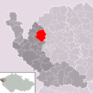
| Location of Nový Kostel in the Cheb district | ||||

|
||||
Nový Kostel (German Neukirchen ) is a municipality in the Czech Republic . It is located seven kilometers east of Plesná ( Fleißen ) and belongs to the Okres Cheb .
geography
Geographical location
Nový Kostel is located in the valley of the Lubinka brook in the south of the Elster Mountains . The Tršnice – Luby railway runs west of the village, and the Nový Kostel railway station is two kilometers west of the village in Spálená. The valley of Libocký potok (Leibitschbach), flooded with the Horka dam, runs to the east .
Community structure
The municipality of Nový Kostel consists of the districts Božetín ( Fassattengrün ), Čižebná ( Zweifelsreuth ), Horka ( Berg ), Hrzín ( Hörsin ), Kopanina ( Frauenreuth ), Mlýnek ( Mühlgrün ), Nový Kostel ( Neukirchen ) and Spálená ( Brenndorf ). Basic settlement units are Bor ( Haid ), Božetín, Čižebná, Horka, Hrzín, Kopanina, Lesná ( Wallhof ), Mlýnek, Nový Kostel, Smrčí ( Krondorf ), Spálená and Svažec ( Ehmet ). Nový Kostel also includes the settlements Nový Dvůr ( Dreigrün ) and Oldřišská ( Ullersgrün ).
The municipality is divided into the cadastral districts Bor u Kopaniny, Božetín, Čižebná, Horka u Milhostova, Hrzín u Nového Kostela, Kopanina, Lesná u Nového Kostela, Mlýnek, Nový Kostel, Smrčí u Nového Kostela and Svažec.
Neighboring communities
| Plesná (Fleißen) | Luby (Schönbach) | |
| Křižovatka (Klinghart) |

|
Krajková (Gossengrün) |
| Milhostov (mill meal) | Habartov (Habersbirk) |
Direct neighbors are Božetín (Fassattengrün) and Oldřišská (Ullersgrün) in the north, Bernov in the northeast, Čižebná in the east, Květná and Kopanina (Frauenreuth) in the southeast, Lesná and Hrzín (Hörsin) in the south and Spálená in the west.
geology
Nový Kostel is located in a center of seismological activity.
history
The area was probably settled in the 13th century by locators from the Waldsassen monastery . In 1348 the monastery sold the Schönbacher Ländchen to Rüdiger von Sparneck for financial reasons . Fassattengrün, Ullersgrün, Frauenreuth, Ehmet, Krondorf, Wallhof, Berg, Hörsin, Zweifelsreuth, Mühlgrün, Brenndorf, Dreigrün and Haid belonged to the Wallhof manor. Until 1838 the owners were the Vladiken Mulz von Walda, who also called themselves "Mulz von Waldau auf Wallhof und Neuhof" for three centuries . They were followed by von Hartenberg's .
Neukirchen itself only came into being after the Reformation in the 17th century. The Wallhof manor, to which this area belonged, was parish to Klinghart before 1444 and then to Frauenreuth. At that time the Klinghart manor was a Protestant area with Evangelical Lutheran belief.
Around 1611 there was a small chapel with a wooden cross in the forest between Wallhof and Neuhof (Brenndorf). The Lords of the Cross with the Red Star on Maria Kulm obtained the right to hold services for the few Catholics in the chapel. One of them, who was cared for in Maria Kulm ( Chlum Svaté Maří ) after an illness, made contact with the local Catholic priest Sebastian Christian. At his suggestion, a Catholic church is said to have been built on the place of the small chapel in 1613, where new settlers who were parish to Kulm settled. In 1657 the church was elevated to a parish church at the request of the landlords Mulz von Waldau . The settlement around the new church was named Neukirchberg and in 1771 had 30 houses; In 1785 there were 50 houses in the village of Neukirch .
In 1840 a long drought led to famine. Ten years later, the military who billeted in the village brought typhus with them. Neukirchen was a farming village whose residents earned extra income by weaving. Later it became a center for domestic violin making . The instruments were bought and exported by Factors in Schönbach .
After the abolition of patrimonial Neukirchen with Brenndorf, Dreigrün, Zweifelsreuth, Ehmet, Krondorf and Wallhof formed a community in the judicial district of Wildstein and in the district of Eger from 1850 . In 1894 a water pipe was built. The school, which had existed since 1657, became a parish school with four classes. In 1879 the place received a new school building. In 1900, the Tirschnitz – Wildstein – Schönbach local railway started operations and promoted the town's economic development. The Neukirchen-Brenndorf railway station was built in Brenndorf. In 1905 a textile school was built. The Czech name Nový Kostel has also been used since 1921. In 1930 there were 1226 predominantly German-speaking people living in the community. The village reached its greatest boom before the Second World War . After the Munich Agreement in 1938, Neukirchen was added to the German Reich and until 1945 belonged to the district of Eger . In 1939 Neukirchen had 1,137 inhabitants. After the end of the war, the community returned to Czechoslovakia and the Germans were expropriated in the course of the expulsion of the Germans from Czechoslovakia in the spring of 1946 and forced to leave the place. Most of the transports went to Bavaria and the Eastern Zone .
Culture and sights
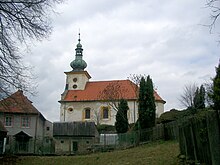
- Church of the Exaltation of the Holy Cross in Nový Kostel, built in 1613. The church was enlarged in 1776. In 1845 lightning struck the church tower, which burned out and melted the bells. In 1884 the clock tower was installed.
- Statues of Our Lady with Infant Jesus with the inscription HISW, S. anno 1716 next to the parish church.
- Statue of St. John of Nepomuk from 1731, in front of the parish church. On the base the inscription: DIVE JOANNES NEPOMUCENSUS TVERRE NOS HIC IN TERRIS ER UBIVIS.
- Church of St. George in Kopanina, a baroque building from the years 1768–1770.
- Manor house in Kopanina, built in the 17th century.
- Historical granary in Kopanina.
- Horka dam .
literature
- Lorenz Schreiner (Ed.): Eger home district. History of a German landscape in documentaries and memories. Amberg in der Oberpfalz 1981, pp. 404-406 Neukirchen (CSR and CSSR Novy Kozel) with a map from 1945, the names of the owners of the 106 houses and three photos of the place
- Lorenz Schreiner (ed.): Monuments in the Egerland. Documentation of a German cultural landscape between Bavaria and Bohemia. With the participation of the state archive in Cheb / Eger under J. Bohac and by V. Baumgarten, R. Fischer, H. Glassl, E. Hammer, E. John, J. Rak, M. Tietz-Strödel, Heribert Sturm and H. and W. White. Amberg in der Oberpfalz 2004, p. 700 Neukirchen / Novy Kostel with an inventory of the buildings and p. 701–703 photos of the sights
Web links
Individual evidence
- ↑ uir.cz
- ↑ Český statistický úřad - The population of the Czech municipalities as of January 1, 2019 (PDF; 7.4 MiB)
- ↑ uir.cz
- ↑ uir.cz
- ↑ uir.cz
- ↑ CSR Valdov, CSSR Lesna
- ^ Rudolf Johann von Meraviglia-Crivelli : Siebmacher's Wappenbuch. Volume IV, Section 9: The Bohemian Nobility. 1886; reprographic reprint: Siebmacher's large book of arms. Volume 30: The coats of arms of the Bohemian nobility. Bauer and Raspe, Neustadt an der Aisch 1979, ISBN 3-87947-030-8 , p. 18, plate 16, coat of arms: Through a curved, up to the top reaching silver tip, in which a natural falcon with a golden collar on a transverse arid Aste stands, split by blue and red, a silver lily in front and a golden lily in the back.
- ↑ see also: Hartenberg Castle Ruins


