
Hazlov
| Hazlov | |||||
|---|---|---|---|---|---|
|
|||||
| Basic data | |||||
| State : |
|
||||
| Region : | Karlovarský kraj | ||||
| District : | Cheb | ||||
| Area : | 2,788.3835 ha | ||||
| Geographic location : | 50 ° 10 ' N , 12 ° 17' E | ||||
| Height: | 550 m nm | ||||
| Residents : | 1,540 (Jan 1, 2019) | ||||
| Postal code : | 351 32 | ||||
| License plate : | K (old CH) | ||||
| structure | |||||
| Status: | local community | ||||
| Districts: | 6th | ||||
| administration | |||||
| Mayor : | Lenka Dvořáková (as of 2018) | ||||
| Address: | Hazlov 31 351 32 Hazlov |
||||
| Municipality number: | 554545 | ||||
| Website : | www.obechazlov.cz | ||||
| Location of Hazlov in the Cheb district | |||||

|
|||||


Hazlov ( German Haslau ) is a municipality in Karlovarský kraj in the Czech Republic .
geography
Geographical location
The place is located at 550 m nm on the road connecting Cheb ( Eger ) and Aš ( Asch ) at the foot of the Hradiště mountain . The location is in the valley of Slatinný potok ( Schladabach ) between the Fichtel and Elster mountains at the southern end of the Ascher Ländchen . The border crossing between Vojtanov and Schönberg am Kapellenberg leads to Germany three kilometers to the east, and the Upper Franconian town of Selb is ten kilometers to the north-west .
Community structure
The municipality of Hazlov consists of the districts Hazlov ( Haslau ), Výhledy ( Steingrün ), Polná ( Hirschfeld ), Skalka ( Rommersreuth ), Táborská ( Seichenreuth ) and Lipná ( Lindau ). Basic settlement units are Hazlov, Lipná, Otov ( Ottengrün ), Ovčárna (sheep farm), Podílná ( half-building ), Polná, Skalka, Táborská and Výhledy. The municipality is divided into the cadastral districts Hazlov, Lipná u Hazlova, Otov u Hazlova, Polná u Hazlova, Skalka u Hazlova, Táborská and Výhledy.
Neighboring places
| Aš (ash) | ||
| Same |
.svg)
|
Bad Brambach |
| Libá (Liebenstein) | Poustka (Oed) | Vojtanov (Voitersreuth) |
history
Haslau castle and fiefdom

The first documentary evidence of a manor house in Haslau, today preserved as Hazlov Castle ruins , dates back to 1224 as Friedrich von Haselah from the noble family of Haslauer von Haslau (Hozlauer von Hozlau) in favor of the Waldsassen Monastery in Nordgau on fief rights in Haselah, Grün and Rommersreuth (Skalka) waived. An associated village Hazlau was mentioned since the end of the 13th century. The following fiefs of the castle and the place Haselah, Hasela, Hasla and Haßla, 1875 Haslau were ministerials of the imperial castle of the Staufer in Eger . The Haslau fiefdom was not too profitable economically. In 1553 a brewery was built with the obligation to buy beer from the subjects of the manor .
Vassals of the castle and the estate Haslau by goods Haslau, Ministeriale out of the house of the Landgrave of Leuchtenberg , Niklas and Hans Jur (Guer) and Heinz von Landwüst to 1492, followed up in 1570 by Hans Malersik, Wilhelm Pergler and of Reitsenstein and 1575 to 1629 by the von Kotzau family . In 1635 the Colonel and Imperial Austrian War Commissioner Dietrich von Steinheim came into possession of Haslau Castle, the Haslau Lehngut and the neighboring Seeberg Castle and the Seeberg ( Ostroh ) estate . Subsequently, Colonel Karl von Schönaich bought Gut Haslau and Gut Seeberg for 6000 Rhenish guilders, had the cemetery church of Sankt Georg in Haslau built and Haslau Castle converted into a castle. From 1682 to 1795, the Knights of Mosern followed and donated the Geißberg and Ledergass chapel.
From 1795 to 1853 Castle and Gut Haslau had bourgeois owners in rapid succession due to the growing profitability due to the industrial development of Haslau. In 1853 Johann Wilhelm Edler von Helmfeld bought the Haslau estate and handed the property over to his son Friedrich Wilhelm von Helmfels, church patron of Haslau, from whom his son Wilhelm inherited it in 1919, who in 1945 shortly before the expropriation and expulsion of the family by the Beneš Decrees died and was buried in the Haslau cemetery crypt. His widow Maria and sons Friedrich and Georg were expropriated in 1945 during the expulsion of the Germans from Czechoslovakia and forced to leave the place. Haslau Castle became generally accessible as a property of Czechoslovakia , used as a quarry and began to deteriorate. The Hazlov castle ruins were renovated after 1990 and rebuilding is planned.
Hazlov market place
Haslau arose before the 12th century from three settlement cores, Haslau Castle, a fortified manor house, which was converted into a castle with a castle church after the Thirty Years War around 1660, a village with peasants in inheritance , which was built in the 12th century at the latest After the characteristic land division of the fields was settled from the Nordgau and the district of Ledergasse, a settlement of craftsmen with job and tool names in East Franconian dialect. This settlement center was located on an old road in the northern part of Hof (Saale) via Rehau and Aš to the imperial city of Eger and was surrounded by small hamlets whose place names were Ziegelhütte, Ecce Homo, Zankhaus, Hirschberg, Hammermühle, Birkicht (am Birke) with the Dreikreuzberg and Untere and Obere Mühle were handed down. There is evidence of a Roman Catholic church in Haslau since 1307.
In 1550, Haslau became Evangelical-Lutheran for three generations through the Augsburg Imperial and Religious Peace . For the first time in 1612, the personal names of the inherited, tax and compulsory residents and the number of men of military age in Haslau can be verified. In 1628, during the re-Catholicization in the Kingdom of Bohemia , Haslau became Roman Catholic again and from 1631 to 1634 members of the Franciscan order preached in the Haslau church. In 1631 and 1647 Haslau was sacked by Swedish Protestant troops, and the castle and church were devastated. Typhus broke out in the village . In a land register from 1634 it can be seen that the village of Haslau had three entire farms with around 16 large cattle and six half farms with small cattle and poultry. The water was supplied from the groundwater via pumps and wells.
Protestant church
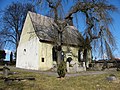
Cemetery chapel


In 1687 and 1688, with the planning of the Jesuit order in Eger, the church was rebuilt as a castle church, which was consecrated by the Regensburg bishop Albert Ernst von Wartenberg . Until the abolition of the order by Emperor Joseph II in 1773, the Jesuits were responsible for the church, the castle and the care of the faithful. Haslau's church registers have been preserved since 1649 with the records of the birth, marriage and death of the residents of Haslau. House numbering was introduced in 1780. The tolerance patent of 1780 made it possible for Evangelical Lutheran and other believers to reside in Haslau. In the Josefinisches Kataster | Josefinisches Kataster of the year 1789 Haslau had 110 houses. An evangelical parish had existed since 1907.
Goethe in Haslau
In August 1831, shortly before his death , Johann Wolfgang von Goethe wrote one last poetic greeting to Bohemia , the four-stanza poem Geognostischer Dank an Haslau, seine Täler und Felsen , which appeared in a private magazine. Every time Goethe traveled to the Bohemian baths on the old post road from Weimar via Hof - Rehau - Asch - Eger, he rested on a large quartz rock on the edge of the Heavenly Forest near Haslau to enjoy the view from there. One of the numerous Goethe stones still reminds of him.
Industrial development
In the first half of the 19th century, home weaving mills and handicraft businesses developed into profitable production facilities. The farming village of Haslau became an industrial and market place with extensive infrastructure. In 1848 the feudal period ended with the peasants' exemption from inheritance , the robot and tax obligation and the customary right of ius primae noctis for the landlord in Haslau as well. As a result of a subsequent reorganization of the administrative districts in the Austro-Hungarian monarchy , Haslau and the surrounding towns of Halbgebäu, Hirschfeld, Lindau, Frankenhaus, Ottengrün , Neuengrün (the later value green), Rommersreuth, Steingrün and Himmelreich became part of the judicial district of Asch and the district of Asch and enlarged it Ascher Ländchen .
Since 1865 Haslau had a train station on the railway line from Eger via Asch to Hof an der Saale and since 1886 the children of the village received schooling, which was expanded in 1922 by a community school. On June 13, 1889, a prolonged downpour with hailstorm flooded the houses in Haslau meters high. Voluntary donations alleviated the hardship. In 1894 a fire destroyed six farms and four houses and a volunteer fire brigade was established.
After 1918 in the time of Czechoslovakia , a post office supplied Haslau and the surrounding area with telegraphic messages and the place received a gendarmerie and customs authority. Jobs that became vacant in these state institutions were increasingly filled with non-resident Czechs. Due to inflation in 1923, the economic crisis of 1929 and 1930 and a sales crisis for textile products, the number of unemployed in Haslau soared and the dissatisfaction of the German residents grew. According to the Munich Agreement , Haslau belonged to the Reichsgau Sudetenland of the German Empire from 1938 to 1945 in the Asch district .
After the Second World War
At the end of the Second World War, Haslau was liberated on May 6, 1945 by US troops advancing into West Bohemia . In October 1945 their presence in Bohemia ended and Russian-Soviet troops reached the border with Bavaria . Haslau came back to Czechoslovakia . From July 1945, the German-speaking house and landowners of the place, which received the official place name Hazlov, were expropriated by Czech commandos and forced to leave the place. The previous livelihood by the industrial companies in Hazlov came to a standstill for the remaining and new settlers of the place after the expulsion of the Germans from Bohemia in the following years. Red light district shaped the appearance of the place. Since the border opening to the Czech Republic in 1990, Hazlov has been crossed by the busy road from Hof (Saale) to Cheb and the reconstruction of an economically secure infrastructure through cross-border projects is sought.
Development of the population
|
|
|
politics
coat of arms
The coat of arms of the municipality of Hazlov is identical to the coat of arms of the noble family Haslauer von Haslau , also Hozlauer von Hozlau, which was resident as an imperial knight in the Egerland , Ascher Ländchen , Hofer Land and later in South Bohemia until the 16th century Century has died out in the male line. They are of the same tribe as von Neuberg , von Schönberg am Kapellenberg and von Raitenbach . Their family coat of arms shows a point, divided into red and silver alternating with the other color. The coat of arms of Hazlov was extended by a red lion in the upper left field, as seen from the viewer, and reminds of the residency of this old family.
Culture and sights
Buildings

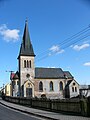
Castle ruins in the foreground

Protestant church


- Hazlov castle ruins
- Protestant church
- Exaltation of the Cross Church
Legends
On the Seeberger Weg in Haslau / Hazlov near the Geißberg chapel, a linden tree stood on a legendary cult site, probably from pre-Christian times, which was said to have healing powers for festering wounds until the 20th century. If a supplicant dabbed off the pus from the wound and pressed it into a pre-drilled hole in the trunk of the linden tree, the disease could be cured.
In connection with retribution and punishment, stone, massive crosses were erected as signs of atonement and repentance for the forgiveness of misdeeds and crimes. The "Hussar Cross" from the time of the Thirty Years' War was brought to the Rehau Museum by expellees .
literature
- Magdalena Šmrhová: Asch and its surroundings in old views . Hosivice 2011. ISBN 978-80-86914-34-3 . P. 262ff.
- Benno Tins: The idiosyncratic history of the Ascher Ländchen . Rehau 1977, text passages on Haslau / Hazlov.
- Willibald Roth: Haslau (dialect Hossla, CSR and CSSR Hazlov), local history in: Heimatkreis Eger - History of a German landscape in documentations and memories, published by the Egerer Landtag eV Heimatverband für Eger Stadt und Land, Amberg in der Oberpfalz, 1981, page 527 to 540 with an overview map of Haslau, Asch district in May 1945 on page 538; a directory of the house owners of Haslau pages 539 and 540 and a picture of the painting by Wenzel Holter from 1868 with the three districts of Haslau, the "village", the "mountain" with the castle and the "Ledergasse".
- Alois John : The Goethestein in Haslau. 1926
Web links
Individual evidence
- ↑ http://www.uir.cz/obec/554545/Hazlov
- ↑ Český statistický úřad - The population of the Czech municipalities as of January 1, 2019 (PDF; 7.4 MiB)
- ↑ http://www.uir.cz/casti-obce-obec/554545/Obec-Hazlov
- ↑ http://www.uir.cz/zsj-obec/554545/Obec-Hazlov
- ↑ http://www.uir.cz/katastralni-uzemi-obec/554545/Obec-Hazlov
- ↑ Ernst Schwarz : Language and Settlement in Northeast Bavaria. Erlanger contributions to linguistics and cultural studies 4, Nuremberg 1960.
- ^ Second volume of the book of eight 1391 to 1668; Urgichtenbuch from 1543 to 1579 under the place name Haßlaw in the state regional archive Cheb
- ↑ Johannes Baier: Goethe and the Egeran von Haslau (Hazlov; Czech Republic) - Z. geol. Wiss., 41/42, 115-122; Berlin, 2013/14.
- ↑ Johannes Urzidil : Goethe in Böhmen, pages 210 and 381, Berlin, Darmstadt, Vienna, 1962
- ↑ Historický lexikon obcí České republiky - 1869–2015. (PDF) Český statistický úřad, December 18, 2015, accessed on February 6, 2016 (Czech).