Luby
| Luby | ||||
|---|---|---|---|---|
|
||||
| Basic data | ||||
| State : |
|
|||
| Region : | Karlovarský kraj | |||
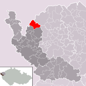
| District : | Cheb | |||
| Area : | 3069.3991 ha | |||
| Geographic location : | 50 ° 15 ' N , 12 ° 24' E | |||
| Height: | 518 m nm | |||
| Residents : | 2,146 (Jan 1, 2019) | |||
| Postal code : | 351 37 | |||
| License plate : | K (old CH) | |||
| traffic | ||||
| Railway connection: | Tršnice – Luby | |||
| structure | ||||
| Status: | city | |||
| Districts: | 4th | |||
| administration | ||||
| Mayor : | Ing.Anita Černíková (status: 2018) | |||
| Address: | Nám. 5.května 164 351 37 Luby |
|||
| Municipality number: | 554634 | |||
| Website : | www.mestoluby.cz | |||
| Location of Luby in the Cheb district | ||||

|
||||
Luby ( German Schönbach ) is a city in Okres Cheb in Karlovarský kraj in the Czech Republic .
geography

Geographical location
Luby is located in the Bohemian part of the Vogtland , on the border with Saxony . The road from Wernitzgrün to Luby has been open to motor vehicles again in the area of the state border since August 2008.
Community structure
The city of Luby consists of the districts Dolní Luby ( Unterschönbach ), Horní Luby ( Oberschönbach ), Luby ( Schönbach ) and Opatov ( Absroth ). Basic development units are Dolni Luby, Flusárna ( Flußhäuser ) Horni Luby, Luby, Luby II, Opatov, Výspa ( Dürr green ) and Zálubí ( Egetten ).
The municipality is divided into the cadastral municipalities of Dolní Luby, Horní Luby, Luby, Luby II, Opatov u Lubů and Výspa.
Neighboring places
| Markneukirchen , Bad Brambach | Kraslice (Graslitz) | |
| Plesná (Fleißen) |

|
Krajková (Gossengrün) |
| Nový Kostel (Neukirchen) |
history
In the Middle Ages, Schönbach was the center of the surrounding landscape, the Schönbacher Ländchen (see also Ascher Ländchen ). The Waldsassen monastery and the von Sparneck family with the burgrave of Eger Rüdiger von Sparneck were known as owners .
The mining of mercury ores , especially cinnabar , has been documented in Oberschönbach ( Horní Luby ) since the middle of the 13th century . Schönbach was raised to town on January 9, 1319 by King Ludwig IV , received a weekly market and was granted town charter based on the model of Eger . Under Abbot Franz Kübel , it was sold together with the surrounding Schönbacher Ländchen in 1348 by the Waldsassen Monastery to Burgrave Rüdiger von Sparneck.
Especially around the 16th century, the deposit was considered to be the most important in Central Europe. In 1536 over 200 miners worked in several pits, the annual production was 13.5 tons of cinnabar. Mining came to a complete standstill during the Thirty Years War . From the middle of the 19th century, the place belonged to the judicial district Wildstein and district Eger .
The city had been a center of violin making since the second half of the 17th century and was named "Austria's Cremona " in a publication in 1897 . In 1929, around 1,500 people were employed in instrument making.
After the First World War , the city was added to the newly created Czechoslovakia in 1919 . On December 1, 1930 the town of Schönbach had 4770 inhabitants, on May 17, 1939 there were 4,269 and on May 22, 1947 2176 inhabitants. Due to the Munich Agreement of 1938, the place was annexed to the German Reich and belonged to the district of Eger , administrative district of Eger , in the Reichsgau Sudetenland . When the "Führer and Reich Chancellor" Adolf Hitler returned from his journey through the annexed Sudetenland on October 3, 1938, he and his convoy used the closed Schönbach / Wernitzgrün border crossing .
After the Second World War , the predominantly German-Bohemian population was expelled . 1600 Schönbachers settled in Bubenreuth near Erlangen , which since then has been another center of violin making alongside Mittenwald in Upper Bavaria and Markneukirchen in the Vogtland Musikwinkel .
Since the end of communism there have been medium-sized instrument makers in Luby again. In June 2005 the violin making school was closed and moved to Cheb.
Population development
Until 1945 Schönbach was predominantly populated by German Bohemia , which were expelled.
| year | Residents | Remarks |
|---|---|---|
| 1847 | 960 | in 112 houses |
| 1869 | 2640 | |
| 1880 | 2967 | |
| 1890 | 3639 | |
| 1900 | 4180 | German residents |
| 1910 | 4890 | |
| 1921 | 4511 | including 4,421 Germans |
| 1930 | 4770 | |
| 1939 | 4268 |
| year | 1950 | 1961 1 | 1970 2 | 1980 2 | 1991 2 | 2001 2 | 2011 2 |
| Residents | 2244 | 2252 | 2551 | 2644 | 2509 | 2478 | 2197 |
sons and daughters of the town
- Ernst Volkmann (1902–1941), conscientious objector in World War II
- Anton Lutz (1908 – after 1945), Austro-German politician
- Willi Brandner (1909–1944), Sudeten German SS brigade leader and major general of the police, politician and police area leader
- Herta Huber (* 1926), German writer
- Walter Aue (* 1930), German writer
- Gerold Karl Hannabach (* 1928 in Schönbach, † 2015 in Bubenreuth), German guitar maker
literature
- Jiří Pátek (ed.): From the history of Egerland violin making , Odborná houslařská škola / Integrovaná střední škola - Houslařská škola, Cheb 2014, ISBN 978-80-260-7712-1 .
Web links
Individual evidence
- ↑ uir.cz
- ↑ Český statistický úřad - The population of the Czech municipalities as of January 1, 2019 (PDF; 7.4 MiB)
- ↑ uir.cz
- ↑ uir.cz
- ↑ uir.cz
- ^ Rudolf Langhammer : Waldsassen - monastery and town . Waldsassen 1936, p. 131.
- ↑ Johann Gottfried Sommer : The Kingdom of Bohemia . Volume 15: Elbogner Kreis , Prague 1847, p. 371, item 7.
- ^ Meyer's Large Conversational Lexicon . 6th edition, Volume 17, Leipzig and Vienna 1909, p. 947.
- ^ Sudetenland Genealogy Network
- ^ A b Michael Rademacher: German administrative history from the unification of the empire in 1871 to the reunification in 1990. City and district of Eger. (Online material for the dissertation, Osnabrück 2006).


